San Isidro elevation
San Isidro (Michoacán, Los Reyes), Mexico elevation is 2589 meters and San Isidro elevation in feet is 8494 ft above sea level [src 1]. San Isidro is a populated place (feature code) with elevation that is 1275 meters (4183 ft) bigger than average city elevation in Mexico.
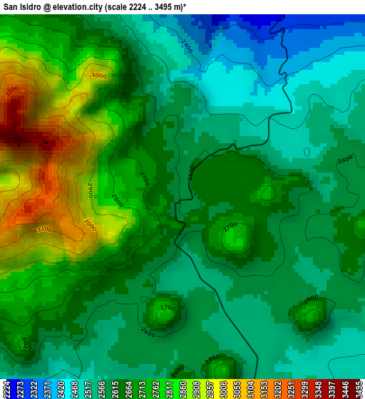
Below is the Elevation map of San Isidro, which displays elevation range with different colors. Scale of the first map is from 2224 to 3495 m (7297 to 11467 ft) with average elevation of 2661.7 meters (=8733 ft) [note 1]
These maps also provides idea of topography and contour of this city, they are displayed at different zoom levels. More info about maps, scale and edge coordinates you can find below images.
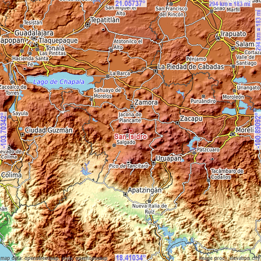
| \ | Map #1 | Topo.Map |
| Scale [m] | 2224..3495 m | × |
| Scale [ft] | 7297..11467 ft | × |
| Average | 2661.7 m = 8733 ft | × |
| Width | 9.2 km = 5.7 mi | 294.3 km = 182.9 mi |
| Height | 9.2 km = 5.7 mi | 294.3 km = 182.9 mi |
| ↑Max Latitude | 19.780698° | 21.05737° |
| Latitude at center | 19.73934° | 19.73934° |
| ↓Min Latitude | 19.697972° | 18.41034° |
| ← Min Longitude | -102.341115° | -103.70342° |
| Longitude center | -102.29717° | -102.29717° |
| →Max Longitude | -102.253225° | -100.89092° |
Nearby cities:
Cities around San Isidro sort by population:
• La Cantera elevation 2147 m
18.1 km,  319°
319°
• Charapán 2368 m
10.9 km,  154°
154°
• Ocumicho 2006 m
10.1 km,  51°
51°
• Pamatácuaro 2419 m
7.3 km,  223°
223°
• Cocucho 2426 m
12.3 km,  113°
113°
• Colonia las Malvinas (Colonia Antorcha) 1723 m
17.2 km,  25°
25°
• Atapán 1582 m
16.6 km,  233°
233°
• J. Jesús Díaz Tzirio 2257 m
10.9 km,  286°
286°
• Corupo 2291 m
15.9 km,  155°
155°
• Zicuicho 2294 m
9.3 km,  203°
203°
• San Benito 2594 m
4.4 km, 215°
• Tengüecho 2186 m
12 km,  336°
336°
Multilingual:
 En español:
San Isidro elevación 2589 m.
 En France:
San Isidro élévation 2589 m.
 Auf Deutsch:
San Isidro höhe über dem Meeresspiegel ist 2589 m.

Sources and notes:
- [note 1] Map square and city borders are not equal. Map elevation data is calculated only from area inside that square.
- [src 1] Elevation data from geonames database provided with same terms of usage.
- [src 2] The elevation map of San Isidro is generated using elevation data from NASA's 3 arcsec (90m) resolution SRTM data.
- [src 3] Base (background) map © OpenStreetMap contributors tiles are generated by Geofabrik and OpenTopoMap.
Copyright & License:
This San Isidro Elevation Map is licensed under CC BY-SA. You may reuse any part from this page, if you give a proper credit by linking to this URL:
 More info on terms of use page.