Atengo elevation
Atengo (Jalisco), Mexico elevation is 1410 meters and Atengo elevation in feet is 4626 ft above sea level [src 1]. Atengo is a seat of a second-order administrative division (feature code) with elevation that is 96 meters (315 ft) bigger than average city elevation in Mexico.
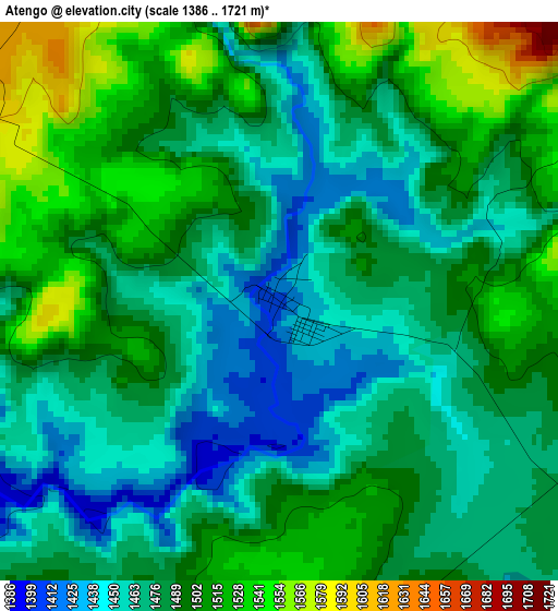
Below is the Elevation map of Atengo, which displays elevation range with different colors. Scale of the first map is from 1386 to 1721 m (4547 to 5646 ft) with average elevation of 1485.6 meters (=4874 ft) [note 1]
These maps also provides idea of topography and contour of this city, they are displayed at different zoom levels. More info about maps, scale and edge coordinates you can find below images.
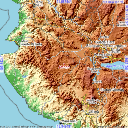
| \ | Map #1 | Topo.Map |
| Scale [m] | 1386..1721 m | × |
| Scale [ft] | 4547..5646 ft | × |
| Average | 1485.6 m = 4874 ft | × |
| Width | 9.17 km = 5.7 mi | 293.3 km = 182.2 mi |
| Height | 9.17 km = 5.7 mi | 293.3 km = 182.2 mi |
| ↑Max Latitude | 20.315337° | 21.58754° |
| Latitude at center | 20.27412° | 20.27412° |
| ↓Min Latitude | 20.232892° | 18.94949° |
| ← Min Longitude | -104.281095° | -105.6434° |
| Longitude center | -104.23715° | -104.23715° |
| →Max Longitude | -104.193205° | -102.8309° |
Nearby cities:
Cities around Atengo sort by population:
• El Salto elevation 1563 m
28.2 km,  283°
283°
• Tecolotlán 1207 m
21.4 km,  112°
112°
• Ayutla 1370 m
19.6 km,  214°
214°
• Tenamaxtlán 1476 m
9.9 km,  129°
129°
• Juchitlán 1250 m
25.5 km,  145°
145°
• Soyatlán del Oro 1599 m
5.5 km,  304°
304°
• Atenguillo 1321 m
31 km, 300°
• Mixtlán 1544 m
25.6 km,  315°
315°
• Tamazulita 1221 m
29 km, 105°
• Cuautla 1719 m
19.5 km,  245°
245°
• Ayotitlán 1273 m
31.2 km,  101°
101°
• San Clemente 1341 m
21.2 km,  184°
184°
Multilingual:
 En español:
Atengo elevación 1410 m.
 En France:
Atengo élévation 1410 m.


Sources and notes:
- [note 1] Map square and city borders are not equal. Map elevation data is calculated only from area inside that square.
- [src 1] Elevation data from geonames database provided with same terms of usage.
- [src 2] The elevation map of Atengo is generated using elevation data from NASA's 3 arcsec (90m) resolution SRTM data.
- [src 3] Base (background) map © OpenStreetMap contributors tiles are generated by Geofabrik and OpenTopoMap.
Copyright & License:
This Atengo Elevation Map is licensed under CC BY-SA. You may reuse any part from this page, if you give a proper credit by linking to this URL:
 More info on terms of use page.