El Salto elevation
El Salto (Jalisco, Atenguillo), Mexico elevation is 1563 meters and El Salto elevation in feet is 5128 ft above sea level [src 1]. El Salto is a populated place (feature code) with elevation that is 249 meters (817 ft) bigger than average city elevation in Mexico.
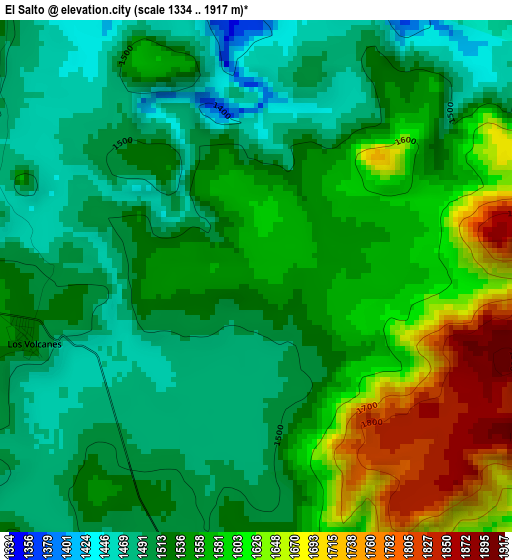
Below is the Elevation map of El Salto, which displays elevation range with different colors. Scale of the first map is from 1334 to 1917 m (4377 to 6289 ft) with average elevation of 1550.6 meters (=5087 ft) [note 1]
These maps also provides idea of topography and contour of this city, they are displayed at different zoom levels. More info about maps, scale and edge coordinates you can find below images.
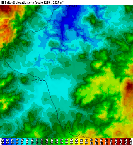
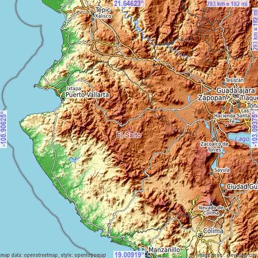
| \ | Map #1 | Map #2 | Topo.Map |
| Scale [m] | 1334..1917 m | 1298..2327 m | × |
| Scale [ft] | 4377..6289 ft | 4259..7635 ft | × |
| Average | 1550.6 m = 5087 ft | 1622.9 m = 5324 ft | × |
| Width | 9.16 km = 5.7 mi | 18.33 km = 11.4 mi | 293.2 km = 182.2 mi |
| Height | 9.16 km = 5.7 mi | 18.33 km = 11.4 mi | 293.2 km = 182.2 mi |
| ↑Max Latitude | 20.374531° | 20.415722° | 21.64623° |
| Latitude at center | 20.33333° | 20.33333° | 20.33333° |
| ↓Min Latitude | 20.292118° | 20.250894° | 19.00919° |
| ← Min Longitude | -104.543945° | -104.587891° | -105.90625° |
| Longitude center | -104.5° | -104.5° | -104.5° |
| →Max Longitude | -104.456055° | -104.412109° | -103.09375° |
Nearby cities:
Cities around El Salto sort by population:
• Unión de Tula elevation 1346 m
48.4 km,  149°
149°
• Talpa de Allende 1159 m
34 km,  278°
278°
• Mascota 1239 m
36.9 km,  305°
305°
• Ayutla 1370 m
28 km,  144°
144°
• Tenamaxtlán 1476 m
37.3 km,  110°
110°
• Soyatlán del Oro 1599 m
23.1 km,  98°
98°
• Guachinango 1496 m
29.8 km,  24°
24°
• Atengo 1410 m
28.2 km, 103°
• Atenguillo 1321 m
9.2 km,  3°
3°
• Mixtlán 1544 m
15.1 km,  39°
39°
• Cuautla 1719 m
17.6 km, 146°
• San Clemente 1341 m
37.9 km, 136°
Multilingual:
 En español:
El Salto elevación 1563 m.
 En France:
El Salto élévation 1563 m.
 Auf Deutsch:
El Salto höhe über dem Meeresspiegel ist 1563 m.

Sources and notes:
- [note 1] Map square and city borders are not equal. Map elevation data is calculated only from area inside that square.
- [src 1] Elevation data from geonames database provided with same terms of usage.
- [src 2] The elevation map of El Salto is generated using elevation data from NASA's 3 arcsec (90m) resolution SRTM data.
- [src 3] Base (background) map © OpenStreetMap contributors tiles are generated by Geofabrik and OpenTopoMap.
Copyright & License:
This El Salto Elevation Map is licensed under CC BY-SA. You may reuse any part from this page, if you give a proper credit by linking to this URL:
 More info on terms of use page.