Ayutla elevation
Ayutla (Jalisco), Mexico elevation is 1370 meters and Ayutla elevation in feet is 4495 ft above sea level [src 1]. Ayutla is a seat of a second-order administrative division (feature code) with elevation that is 56 meters (184 ft) bigger than average city elevation in Mexico.
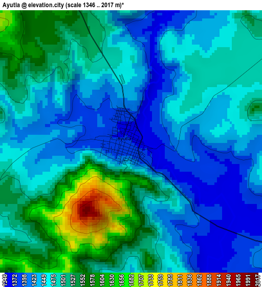
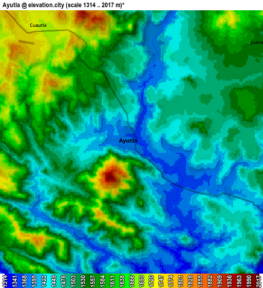
Below is the Elevation map of Ayutla, which displays elevation range with different colors. Scale of the first map is from 1346 to 2017 m (4416 to 6617 ft) with average elevation of 1480.7 meters (=4858 ft) [note 1]
These maps also provides idea of topography and contour of this city, they are displayed at different zoom levels. More info about maps, scale and edge coordinates you can find below images.
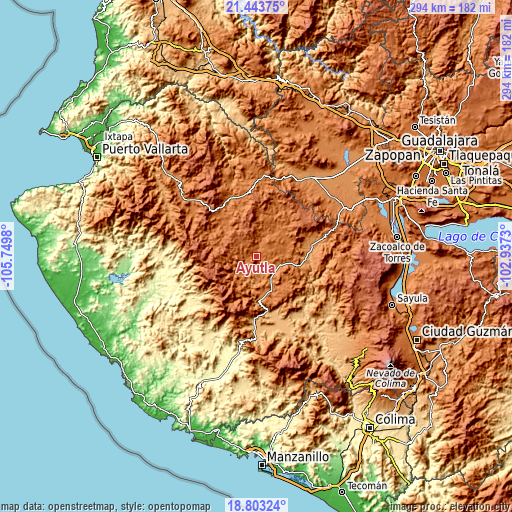
| \ | Map #1 | Map #2 | Topo.Map |
| Scale [m] | 1346..2017 m | 1314..2017 m | × |
| Scale [ft] | 4416..6617 ft | 4311..6617 ft | × |
| Average | 1480.7 m = 4858 ft | 1517.3 m = 4978 ft | × |
| Width | 9.18 km = 5.7 mi | 18.35 km = 11.4 mi | 293.6 km = 182.4 mi |
| Height | 9.18 km = 5.7 mi | 18.35 km = 11.4 mi | 293.6 km = 182.4 mi |
| ↑Max Latitude | 20.170326° | 20.21157° | 21.44375° |
| Latitude at center | 20.12907° | 20.12907° | 20.12907° |
| ↓Min Latitude | 20.087803° | 20.046526° | 18.80324° |
| ← Min Longitude | -104.387495° | -104.431441° | -105.7498° |
| Longitude center | -104.34355° | -104.34355° | -104.34355° |
| →Max Longitude | -104.299605° | -104.255659° | -102.9373° |
Nearby cities:
Cities around Ayutla sort by population:
• El Salto elevation 1563 m
28 km,  324°
324°
• Tecolotlán 1207 m
31.9 km,  75°
75°
• Unión de Tula 1346 m
20.7 km,  157°
157°
• La Tijera 1744 m
26.1 km,  193°
193°
• Tenamaxtlán 1476 m
21.1 km,  62°
62°
• Juchitlán 1250 m
26 km,  100°
100°
• Soyatlán del Oro 1599 m
20.3 km,  18°
18°
• Atengo 1410 m
19.6 km,  34°
34°
• Ejutla 1136 m
31.3 km,  142°
142°
• El Corcovado 902 m
32.1 km,  169°
169°
• Cuautla 1719 m
10.5 km, 320°
• San Clemente 1341 m
10.8 km,  117°
117°
Multilingual:
 En español:
Ayutla elevación 1370 m.
 En France:
Ayutla élévation 1370 m.


Sources and notes:
- [note 1] Map square and city borders are not equal. Map elevation data is calculated only from area inside that square.
- [src 1] Elevation data from geonames database provided with same terms of usage.
- [src 2] The elevation map of Ayutla is generated using elevation data from NASA's 3 arcsec (90m) resolution SRTM data.
- [src 3] Base (background) map © OpenStreetMap contributors tiles are generated by Geofabrik and OpenTopoMap.
Copyright & License:
This Ayutla Elevation Map is licensed under CC BY-SA. You may reuse any part from this page, if you give a proper credit by linking to this URL:
 More info on terms of use page.