La Tijera elevation
La Tijera (Jalisco, Autlán de Navarro), Mexico elevation is 1744 meters and La Tijera elevation in feet is 5722 ft above sea level [src 1]. La Tijera is a populated place (feature code) with elevation that is 430 meters (1411 ft) bigger than average city elevation in Mexico.
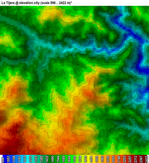
Below is the Elevation map of La Tijera, which displays elevation range with different colors. Scale of the first map is from 996 to 2422 m (3268 to 7946 ft) with average elevation of 1629.1 meters (=5345 ft) [note 1]
These maps also provides idea of topography and contour of this city, they are displayed at different zoom levels. More info about maps, scale and edge coordinates you can find below images.
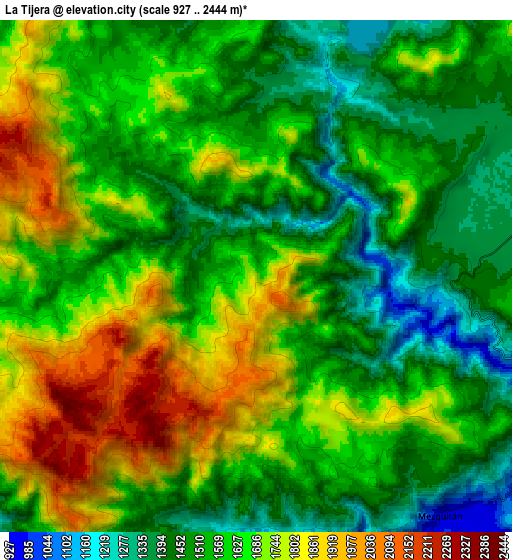
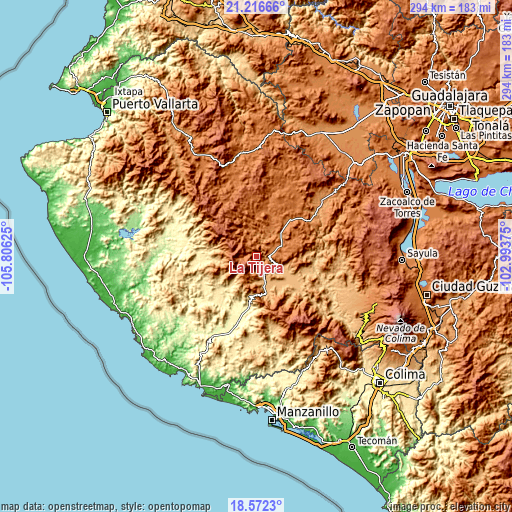
| \ | Map #1 | Map #2 | Topo.Map |
| Scale [m] | 996..2422 m | 927..2444 m | × |
| Scale [ft] | 3268..7946 ft | 3041..8018 ft | × |
| Average | 1629.1 m = 5345 ft | 1604.8 m = 5265 ft | × |
| Width | 9.19 km = 5.7 mi | 18.38 km = 11.4 mi | 294 km = 182.7 mi |
| Height | 9.19 km = 5.7 mi | 18.38 km = 11.4 mi | 294 km = 182.7 mi |
| ↑Max Latitude | 19.941316° | 19.982621° | 21.21666° |
| Latitude at center | 19.9° | 19.9° | 19.9° |
| ↓Min Latitude | 19.858673° | 19.817336° | 18.5723° |
| ← Min Longitude | -104.443945° | -104.487891° | -105.80625° |
| Longitude center | -104.4° | -104.4° | -104.4° |
| →Max Longitude | -104.356055° | -104.312109° | -102.99375° |
Nearby cities:
Cities around La Tijera sort by population:
• Autlán de Navarro elevation 915 m
15.1 km,  166°
166°
• El Grullo 878 m
21.7 km,  118°
118°
• Unión de Tula 1346 m
15.2 km,  65°
65°
• Ayutla 1370 m
26.1 km,  13°
13°
• Purificación 452 m
29.6 km,  226°
226°
• El Limón 880 m
26.8 km,  108°
108°
• El Chante 903 m
29.1 km,  134°
134°
• Ejutla 1136 m
24.9 km,  88°
88°
• El Mentidero 886 m
18.2 km,  142°
142°
• El Corcovado 902 m
13.4 km, 116°
• San Clemente 1341 m
25.7 km,  37°
37°
• La Ciénega 883 m
28.3 km,  104°
104°
Multilingual:
 En español:
La Tijera elevación 1744 m.
 En France:
La Tijera élévation 1744 m.
 Auf Deutsch:
La Tijera höhe über dem Meeresspiegel ist 1744 m.

Sources and notes:
- [note 1] Map square and city borders are not equal. Map elevation data is calculated only from area inside that square.
- [src 1] Elevation data from geonames database provided with same terms of usage.
- [src 2] The elevation map of La Tijera is generated using elevation data from NASA's 3 arcsec (90m) resolution SRTM data.
- [src 3] Base (background) map © OpenStreetMap contributors tiles are generated by Geofabrik and OpenTopoMap.
Copyright & License:
This La Tijera Elevation Map is licensed under CC BY-SA. You may reuse any part from this page, if you give a proper credit by linking to this URL:
 More info on terms of use page.