Autlán de Navarro elevation
Autlán de Navarro (Jalisco), Mexico elevation is 915 meters and Autlán de Navarro elevation in feet is 3002 ft above sea level [src 1]. Autlán de Navarro is a seat of a second-order administrative division (feature code) with elevation that is 399 meters (1309 ft) smaller than average city elevation in Mexico.
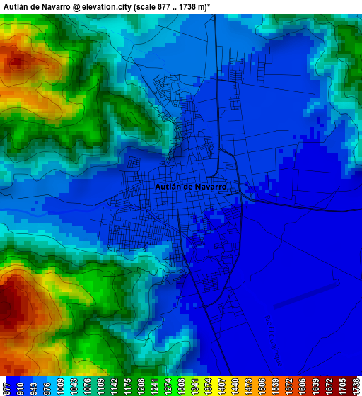
Below is the Elevation map of Autlán de Navarro, which displays elevation range with different colors. Scale of the first map is from 877 to 1738 m (2877 to 5702 ft) with average elevation of 1034.6 meters (=3394 ft) [note 1]
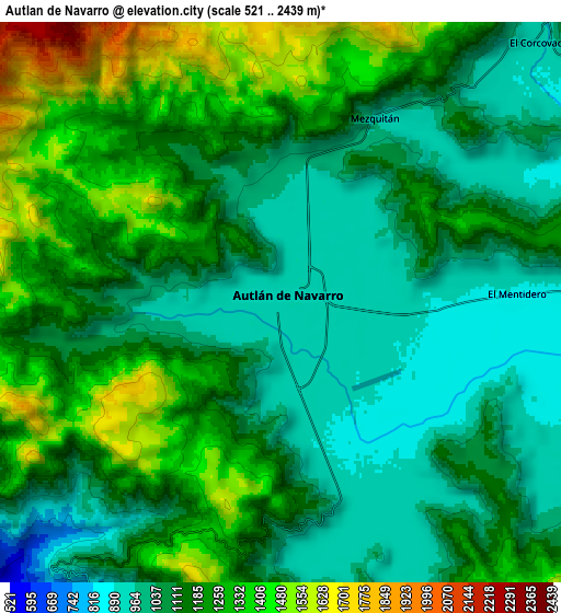
These maps also provides idea of topography and contour of this city, they are displayed at different zoom levels. More info about maps, scale and edge coordinates you can find below images.
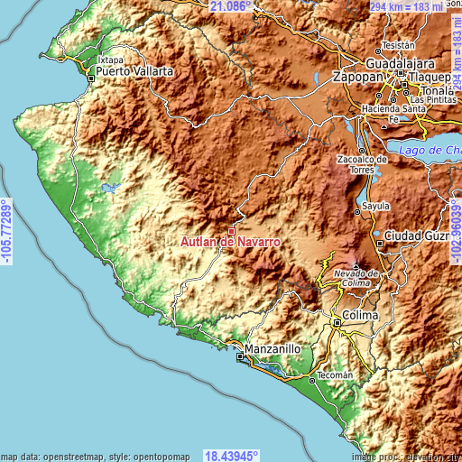
| \ | Map #1 | Map #2 | Topo.Map |
| Scale [m] | 877..1738 m | 521..2439 m | × |
| Scale [ft] | 2877..5702 ft | 1709..8002 ft | × |
| Average | 1034.6 m = 3394 ft | 1160.8 m = 3808 ft | × |
| Width | 9.2 km = 5.7 mi | 18.39 km = 11.4 mi | 294.3 km = 182.9 mi |
| Height | 9.2 km = 5.7 mi | 18.39 km = 11.4 mi | 294.3 km = 182.9 mi |
| ↑Max Latitude | 19.80957° | 19.85091° | 21.086° |
| Latitude at center | 19.76822° | 19.76822° | 19.76822° |
| ↓Min Latitude | 19.726859° | 19.685487° | 18.43945° |
| ← Min Longitude | -104.410585° | -104.454531° | -105.77289° |
| Longitude center | -104.36664° | -104.36664° | -104.36664° |
| →Max Longitude | -104.322695° | -104.278749° | -102.96039° |
Nearby cities:
Cities around Autlán de Navarro sort by population:
• El Grullo elevation 878 m
16.1 km,  74°
74°
• La Resolana 371 m
19.5 km,  201°
201°
• Unión de Tula 1346 m
23.3 km,  26°
26°
• La Tijera 1744 m
15.1 km,  346°
346°
• Purificación 452 m
25.6 km,  257°
257°
• Lo Arado 300 m
24 km,  227°
227°
• El Limón 880 m
22.9 km, 73°
• El Chante 903 m
18.3 km,  107°
107°
• Ejutla 1136 m
26.3 km,  54°
54°
• El Mentidero 886 m
7.7 km,  87°
87°
• El Corcovado 902 m
12 km,  44°
44°
• La Ciénega 883 m
25.1 km, 72°
Multilingual:
 En español:
Autlán de Navarro elevación 915 m.
 En France:
Autlán de Navarro élévation 915 m.
 Auf Deutsch:
Autlán de Navarro höhe über dem Meeresspiegel ist 915 m.

Sources and notes:
- [note 1] Map square and city borders are not equal. Map elevation data is calculated only from area inside that square.
- [src 1] Elevation data from geonames database provided with same terms of usage.
- [src 2] The elevation map of Autlán de Navarro is generated using elevation data from NASA's 3 arcsec (90m) resolution SRTM data.
- [src 3] Base (background) map © OpenStreetMap contributors tiles are generated by Geofabrik and OpenTopoMap.
Copyright & License:
This Autlán de Navarro Elevation Map is licensed under CC BY-SA. You may reuse any part from this page, if you give a proper credit by linking to this URL:
 More info on terms of use page.