Ayotitlán elevation
Ayotitlán (Jalisco, Tecolotlán), Mexico elevation is 1273 meters and Ayotitlán elevation in feet is 4177 ft above sea level [src 1]. Ayotitlán is a populated place (feature code) with elevation that is 41 meters (135 ft) smaller than average city elevation in Mexico.
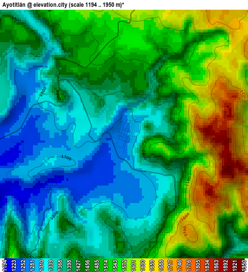
Below is the Elevation map of Ayotitlán, which displays elevation range with different colors. Scale of the first map is from 1194 to 1950 m (3917 to 6398 ft) with average elevation of 1451.5 meters (=4762 ft) [note 1]
These maps also provides idea of topography and contour of this city, they are displayed at different zoom levels. More info about maps, scale and edge coordinates you can find below images.
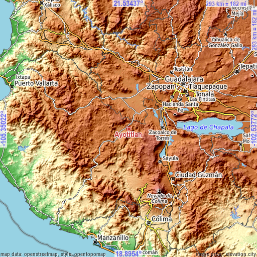
| \ | Map #1 | Topo.Map |
| Scale [m] | 1194..1950 m | × |
| Scale [ft] | 3917..6398 ft | × |
| Average | 1451.5 m = 4762 ft | × |
| Width | 9.17 km = 5.7 mi | 293.4 km = 182.3 mi |
| Height | 9.17 km = 5.7 mi | 293.4 km = 182.3 mi |
| ↑Max Latitude | 20.261711° | 21.53437° |
| Latitude at center | 20.22048° | 20.22048° |
| ↓Min Latitude | 20.179238° | 18.8954° |
| ← Min Longitude | -103.987915° | -105.35022° |
| Longitude center | -103.94397° | -103.94397° |
| →Max Longitude | -103.900025° | -102.53772° |
Nearby cities:
Cities around Ayotitlán sort by population:
• Cocula elevation 1349 m
20.5 km,  38°
38°
• Tecolotlán 1207 m
11 km,  259°
259°
• San Martín Hidalgo 1308 m
23.9 km,  3°
3°
• Atemajac de Brizuela 2354 m
24.6 km,  112°
112°
• Tenamaxtlán 1476 m
23 km,  269°
269°
• Chiquilistlán 1730 m
17.1 km,  149°
149°
• Chiquilistlán 1665 m
13.5 km,  99°
99°
• Juchitlán 1250 m
22 km,  227°
227°
• El Crucero de Santa María 1320 m
20 km,  25°
25°
• Estipa 1379 m
27.9 km,  55°
55°
• Santa Cruz de las Flores 1363 m
19.3 km,  358°
358°
• Tamazulita 1221 m
3.2 km,  236°
236°
Multilingual:
 En español:
Ayotitlán elevación 1273 m.
 En France:
Ayotitlán élévation 1273 m.
 Auf Deutsch:
Ayotitlán höhe über dem Meeresspiegel ist 1273 m.

Sources and notes:
- [note 1] Map square and city borders are not equal. Map elevation data is calculated only from area inside that square.
- [src 1] Elevation data from geonames database provided with same terms of usage.
- [src 2] The elevation map of Ayotitlán is generated using elevation data from NASA's 3 arcsec (90m) resolution SRTM data.
- [src 3] Base (background) map © OpenStreetMap contributors tiles are generated by Geofabrik and OpenTopoMap.
Copyright & License:
This Ayotitlán Elevation Map is licensed under CC BY-SA. You may reuse any part from this page, if you give a proper credit by linking to this URL:
 More info on terms of use page.