Chiquilistlán elevation
Chiquilistlán (Jalisco, Atemajac de Brizuela), Mexico elevation is 1665 meters and Chiquilistlán elevation in feet is 5463 ft above sea level [src 1]. Chiquilistlán is a populated place (feature code) with elevation that is 351 meters (1152 ft) bigger than average city elevation in Mexico.
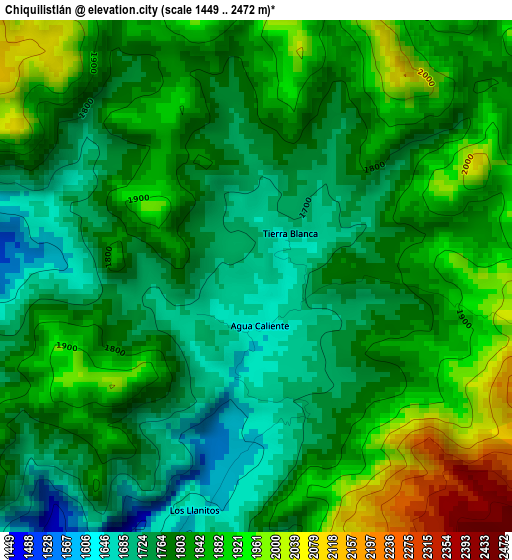
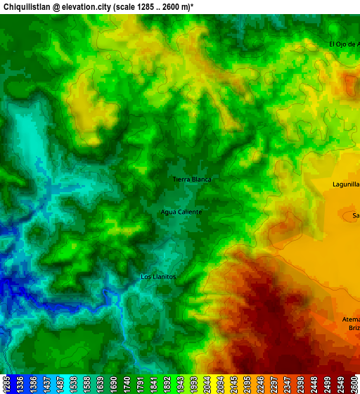
Below is the Elevation map of Chiquilistlán, which displays elevation range with different colors. Scale of the first map is from 1449 to 2472 m (4754 to 8110 ft) with average elevation of 1814.2 meters (=5952 ft) [note 1]
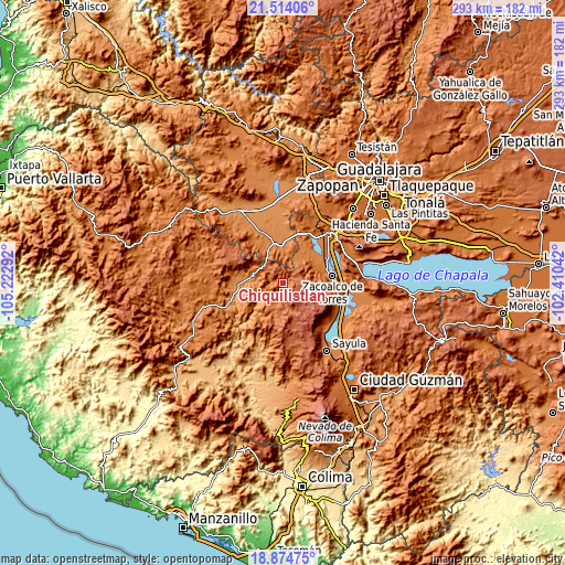
These maps also provides idea of topography and contour of this city, they are displayed at different zoom levels. More info about maps, scale and edge coordinates you can find below images.
| \ | Map #1 | Map #2 | Topo.Map |
| Scale [m] | 1449..2472 m | 1285..2600 m | × |
| Scale [ft] | 4754..8110 ft | 4216..8530 ft | × |
| Average | 1814.2 m = 5952 ft | 1888.9 m = 6197 ft | × |
| Width | 9.17 km = 5.7 mi | 18.34 km = 11.4 mi | 293.5 km = 182.4 mi |
| Height | 9.17 km = 5.7 mi | 18.34 km = 11.4 mi | 293.5 km = 182.4 mi |
| ↑Max Latitude | 20.241237° | 20.282463° | 21.51406° |
| Latitude at center | 20.2° | 20.2° | 20.2° |
| ↓Min Latitude | 20.158752° | 20.117493° | 18.87475° |
| ← Min Longitude | -103.860615° | -103.904561° | -105.22292° |
| Longitude center | -103.81667° | -103.81667° | -103.81667° |
| →Max Longitude | -103.772725° | -103.728779° | -102.41042° |
Nearby cities:
Cities around Chiquilistlán sort by population:
• Cocula elevation 1349 m
18.4 km,  358°
358°
• Tecolotlán 1207 m
24.1 km,  270°
270°
• Atemajac de Brizuela 2354 m
11.8 km,  126°
126°
• Chiquilistlán 1730 m
13.3 km,  200°
200°
• El Crucero de Santa María 1320 m
20.9 km,  347°
347°
• Juanacatlán 2518 m
23 km,  143°
143°
• Estipa 1379 m
20.5 km,  28°
28°
• Atotonilco el Bajo 1357 m
22.4 km,  41°
41°
• Juan Gil Preciado 1389 m
21.3 km, 25°
• Tamazulita 1221 m
15.9 km, 271°
• Ayotitlán 1273 m
13.5 km,  279°
279°
• Barranca de Otates (Barranca de Otatán) 1477 m
17.6 km,  64°
64°
Multilingual:
 En español:
Chiquilistlán elevación 1665 m.
 En France:
Chiquilistlán élévation 1665 m.
 Auf Deutsch:
Chiquilistlán höhe über dem Meeresspiegel ist 1665 m.

Sources and notes:
- [note 1] Map square and city borders are not equal. Map elevation data is calculated only from area inside that square.
- [src 1] Elevation data from geonames database provided with same terms of usage.
- [src 2] The elevation map of Chiquilistlán is generated using elevation data from NASA's 3 arcsec (90m) resolution SRTM data.
- [src 3] Base (background) map © OpenStreetMap contributors tiles are generated by Geofabrik and OpenTopoMap.
Copyright & License:
This Chiquilistlán Elevation Map is licensed under CC BY-SA. You may reuse any part from this page, if you give a proper credit by linking to this URL:
 More info on terms of use page.