Cocula elevation
Cocula (Jalisco), Mexico elevation is 1349 meters and Cocula elevation in feet is 4426 ft above sea level [src 1]. Cocula is a populated place (feature code) with elevation that is 35 meters (115 ft) bigger than average city elevation in Mexico.
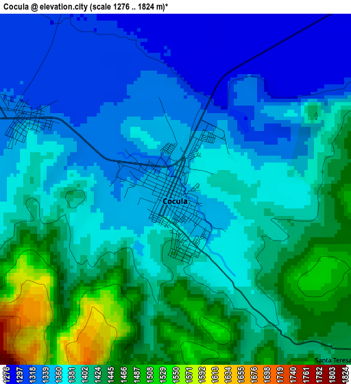
Below is the Elevation map of Cocula, which displays elevation range with different colors. Scale of the first map is from 1276 to 1824 m (4186 to 5984 ft) with average elevation of 1388.5 meters (=4555 ft) [note 1]
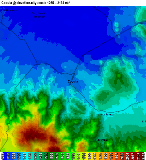
These maps also provides idea of topography and contour of this city, they are displayed at different zoom levels. More info about maps, scale and edge coordinates you can find below images.
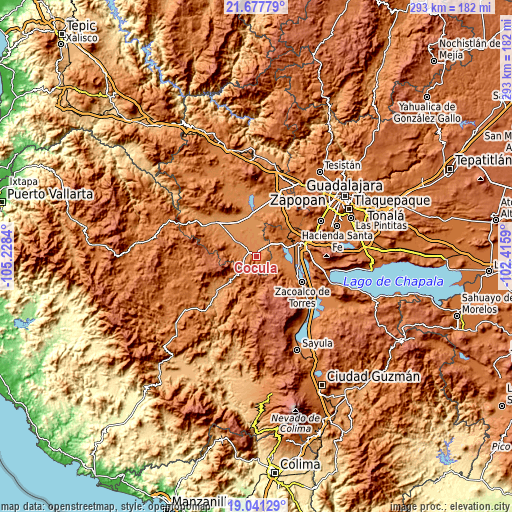
| \ | Map #1 | Map #2 | Topo.Map |
| Scale [m] | 1276..1824 m | 1265..2134 m | × |
| Scale [ft] | 4186..5984 ft | 4150..7001 ft | × |
| Average | 1388.5 m = 4555 ft | 1448 m = 4751 ft | × |
| Width | 9.16 km = 5.7 mi | 18.32 km = 11.4 mi | 293.2 km = 182.2 mi |
| Height | 9.16 km = 5.7 mi | 18.32 km = 11.4 mi | 293.2 km = 182.2 mi |
| ↑Max Latitude | 20.406363° | 20.447545° | 21.67779° |
| Latitude at center | 20.36517° | 20.36517° | 20.36517° |
| ↓Min Latitude | 20.323966° | 20.282751° | 19.04129° |
| ← Min Longitude | -103.866095° | -103.910041° | -105.2284° |
| Longitude center | -103.82215° | -103.82215° | -103.82215° |
| →Max Longitude | -103.778205° | -103.734259° | -102.4159° |
Nearby cities:
Cities around Cocula sort by population:
• San Martín Hidalgo elevation 1308 m
13.6 km,  305°
305°
• Villa Corona 1359 m
17.4 km,  71°
71°
• Chiquilistlán 1665 m
18.4 km,  178°
178°
• El Crucero de Santa María 1320 m
4.5 km,  296°
296°
• El Salitre 1262 m
16.6 km,  347°
347°
• Estipa 1379 m
10.3 km,  91°
91°
• Atotonilco el Bajo 1357 m
15.5 km,  95°
95°
• Juan Gil Preciado 1389 m
9.9 km, 85°
• Santa Cruz de las Flores 1363 m
13.6 km,  283°
283°
• Trapiche de Abra 1260 m
19.4 km,  0°
0°
• La Sauceda 1275 m
9.8 km,  9°
9°
• Barranca de Otates (Barranca de Otatán) 1477 m
19.6 km,  123°
123°
Multilingual:
 En español:
Cocula elevación 1349 m.
 En France:
Cocula élévation 1349 m.


Sources and notes:
- [note 1] Map square and city borders are not equal. Map elevation data is calculated only from area inside that square.
- [src 1] Elevation data from geonames database provided with same terms of usage.
- [src 2] The elevation map of Cocula is generated using elevation data from NASA's 3 arcsec (90m) resolution SRTM data.
- [src 3] Base (background) map © OpenStreetMap contributors tiles are generated by Geofabrik and OpenTopoMap.
Copyright & License:
This Cocula Elevation Map is licensed under CC BY-SA. You may reuse any part from this page, if you give a proper credit by linking to this URL:
 More info on terms of use page.