San Martín Hidalgo elevation
San Martín Hidalgo (Jalisco), Mexico elevation is 1308 meters and San Martín Hidalgo elevation in feet is 4291 ft above sea level [src 1]. San Martín Hidalgo is a populated place (feature code) with elevation that is 6 meters (20 ft) smaller than average city elevation in Mexico.
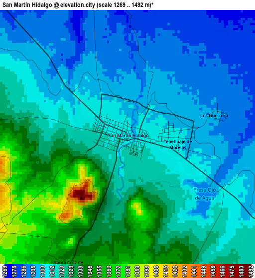
Below is the Elevation map of San Martín Hidalgo, which displays elevation range with different colors. Scale of the first map is from 1269 to 1492 m (4163 to 4895 ft) with average elevation of 1317.3 meters (=4322 ft) [note 1]
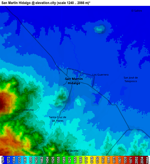
These maps also provides idea of topography and contour of this city, they are displayed at different zoom levels. More info about maps, scale and edge coordinates you can find below images.
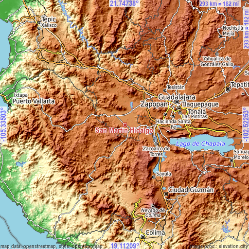
| \ | Map #1 | Map #2 | Topo.Map |
| Scale [m] | 1269..1492 m | 1240..2066 m | × |
| Scale [ft] | 4163..4895 ft | 4068..6778 ft | × |
| Average | 1317.3 m = 4322 ft | 1355.2 m = 4446 ft | × |
| Width | 9.16 km = 5.7 mi | 18.32 km = 11.4 mi | 293 km = 182.1 mi |
| Height | 9.16 km = 5.7 mi | 18.31 km = 11.4 mi | 293 km = 182.1 mi |
| ↑Max Latitude | 20.476554° | 20.517717° | 21.74738° |
| Latitude at center | 20.43538° | 20.43538° | 20.43538° |
| ↓Min Latitude | 20.394195° | 20.352999° | 19.11209° |
| ← Min Longitude | -103.972725° | -104.016671° | -105.33503° |
| Longitude center | -103.92878° | -103.92878° | -103.92878° |
| →Max Longitude | -103.884835° | -103.840889° | -102.52253° |
Nearby cities:
Cities around San Martín Hidalgo sort by population:
• Ameca elevation 1234 m
17.3 km,  315°
315°
• Cocula 1349 m
13.6 km,  125°
125°
• El Crucero de Santa María 1320 m
9.1 km, 129°
• El Salitre 1262 m
11.2 km,  41°
41°
• El Cabezón 1270 m
7.1 km,  340°
340°
• Buenavista 1250 m
16.8 km,  28°
28°
• La Vega 1263 m
18 km,  24°
24°
• Santa Cruz de las Flores 1363 m
5 km,  204°
204°
• Trapiche de Abra 1260 m
16.2 km, 44°
• La Sauceda 1275 m
12.8 km,  81°
81°
• Punta de la Vega 1275 m
17.6 km,  10°
10°
• Los Pocitos 1247 m
11.4 km,  355°
355°
Multilingual:
 En español:
San Martín Hidalgo elevación 1308 m.
 En France:
San Martín Hidalgo élévation 1308 m.
 Auf Deutsch:
San Martín Hidalgo höhe über dem Meeresspiegel ist 1308 m.
 На русском:
San Martín Hidalgo высота над уровнем моря 1308 м
Sources and notes:
- [note 1] Map square and city borders are not equal. Map elevation data is calculated only from area inside that square.
- [src 1] Elevation data from geonames database provided with same terms of usage.
- [src 2] The elevation map of San Martín Hidalgo is generated using elevation data from NASA's 3 arcsec (90m) resolution SRTM data.
- [src 3] Base (background) map © OpenStreetMap contributors tiles are generated by Geofabrik and OpenTopoMap.
Copyright & License:
This San Martín Hidalgo Elevation Map is licensed under CC BY-SA. You may reuse any part from this page, if you give a proper credit by linking to this URL:
 More info on terms of use page.