Carichí elevation
Carichí (Chihuahua), Mexico elevation is 2075 meters and Carichí elevation in feet is 6808 ft above sea level [src 1]. Carichí is a seat of a second-order administrative division (feature code) with elevation that is 761 meters (2497 ft) bigger than average city elevation in Mexico.
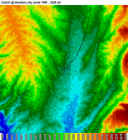
Below is the Elevation map of Carichí, which displays elevation range with different colors. Scale of the first map is from 1999 to 2228 m (6558 to 7310 ft) with average elevation of 2096 meters (=6877 ft) [note 1]
These maps also provides idea of topography and contour of this city, they are displayed at different zoom levels. More info about maps, scale and edge coordinates you can find below images.
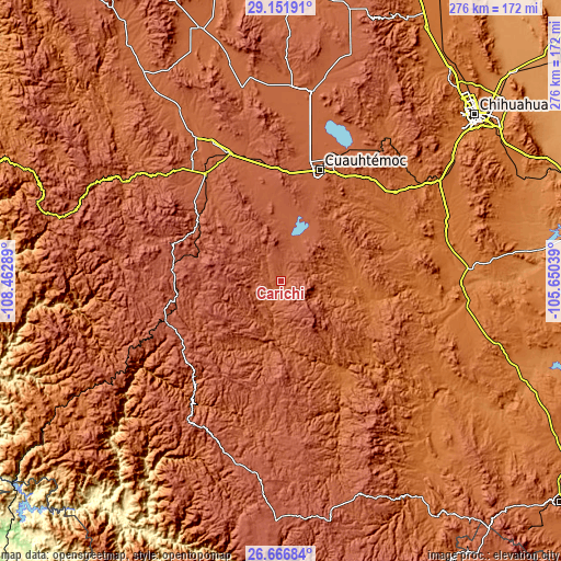
| \ | Map #1 | Topo.Map |
| Scale [m] | 1999..2228 m | × |
| Scale [ft] | 6558..7310 ft | × |
| Average | 2096 m = 6877 ft | × |
| Width | 8.64 km = 5.4 mi | 276.3 km = 171.7 mi |
| Height | 8.64 km = 5.4 mi | 276.3 km = 171.7 mi |
| ↑Max Latitude | 27.955334° | 29.15191° |
| Latitude at center | 27.91651° | 27.91651° |
| ↓Min Latitude | 27.877672° | 26.66684° |
| ← Min Longitude | -107.100585° | -108.46289° |
| Longitude center | -107.05664° | -107.05664° |
| →Max Longitude | -107.012695° | -105.65039° |
Nearby cities:
Cities around Carichí sort by population:
• Cuauhtémoc elevation 2051 m
57.9 km,  19°
19°
• San Juanito 2405 m
53.9 km,  276°
276°
• Adolfo López Mateos 2097 m
65.7 km,  338°
338°
• Valentín Gómez Farías 1739 m
57.2 km,  54°
54°
• Creel 2346 m
59.8 km,  252°
252°
• Nonoava 1643 m
58.6 km,  147°
147°
• San Francisco de Borja 1646 m
36.5 km,  92°
92°
• Sisoguichi 2212 m
45.6 km, 251°
• Bocoyna 2231 m
53 km,  260°
260°
• Carretas 1676 m
65.1 km,  55°
55°
• San Lorenzo 1602 m
62.7 km,  65°
65°
• Cusihuiriachi 2000 m
42 km,  31°
31°
Multilingual:
 En español:
Carichí elevación 2075 m.
 En France:
Carichí élévation 2075 m.
 Auf Deutsch:
Carichí höhe über dem Meeresspiegel ist 2075 m.

Sources and notes:
- [note 1] Map square and city borders are not equal. Map elevation data is calculated only from area inside that square.
- [src 1] Elevation data from geonames database provided with same terms of usage.
- [src 2] The elevation map of Carichí is generated using elevation data from NASA's 3 arcsec (90m) resolution SRTM data.
- [src 3] Base (background) map © OpenStreetMap contributors tiles are generated by Geofabrik and OpenTopoMap.
Copyright & License:
This Carichí Elevation Map is licensed under CC BY-SA. You may reuse any part from this page, if you give a proper credit by linking to this URL:
 More info on terms of use page.