Creel elevation
Creel (Chihuahua, Bocoyna), Mexico elevation is 2346 meters and Creel elevation in feet is 7697 ft above sea level [src 1]. Creel is a populated place (feature code) with elevation that is 1032 meters (3386 ft) bigger than average city elevation in Mexico.
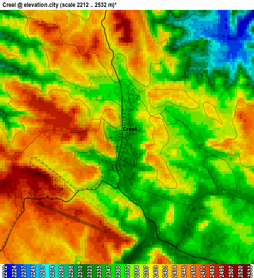
Below is the Elevation map of Creel, which displays elevation range with different colors. Scale of the first map is from 2212 to 2532 m (7257 to 8307 ft) with average elevation of 2391.2 meters (=7845 ft) [note 1]
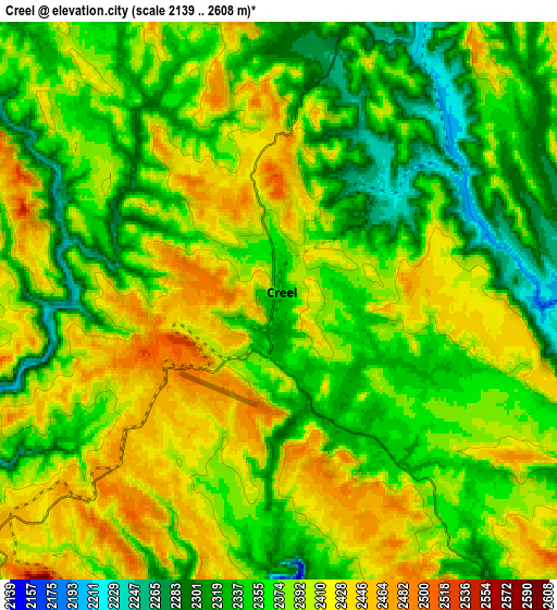
These maps also provides idea of topography and contour of this city, they are displayed at different zoom levels. More info about maps, scale and edge coordinates you can find below images.
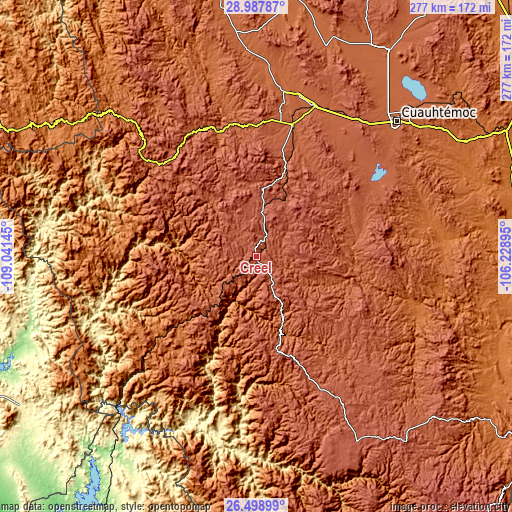
| \ | Map #1 | Map #2 | Topo.Map |
| Scale [m] | 2212..2532 m | 2139..2608 m | × |
| Scale [ft] | 7257..8307 ft | 7018..8556 ft | × |
| Average | 2391.2 m = 7845 ft | 2376.7 m = 7798 ft | × |
| Width | 8.65 km = 5.4 mi | 17.3 km = 10.7 mi | 276.7 km = 171.9 mi |
| Height | 8.65 km = 5.4 mi | 17.3 km = 10.7 mi | 276.7 km = 171.9 mi |
| ↑Max Latitude | 27.789424° | 27.828294° | 28.98787° |
| Latitude at center | 27.75054° | 27.75054° | 27.75054° |
| ↓Min Latitude | 27.711642° | 27.672731° | 26.49899° |
| ← Min Longitude | -107.679145° | -107.723091° | -109.04145° |
| Longitude center | -107.6352° | -107.6352° | -107.6352° |
| →Max Longitude | -107.591255° | -107.547309° | -106.22895° |
Nearby cities:
Cities around Creel sort by population:
• San Juanito elevation 2405 m
24.9 km,  7°
7°
• Tomochic 1933 m
70.1 km,  342°
342°
• San Rafael 2174 m
37.8 km,  221°
221°
• Carichí 2075 m
59.8 km,  72°
72°
• Cerocahui 1627 m
65.1 km, 219°
• Bahuichivo 1639 m
57 km,  228°
228°
• Samachique 2143 m
50.8 km,  169°
169°
• Uruachi 1356 m
58.5 km,  282°
282°
• Urique 551 m
66 km,  204°
204°
• Sisoguichi 2212 m
14.2 km,  75°
75°
• Maguarichi 1676 m
37.3 km,  288°
288°
• Bocoyna 2231 m
11.1 km,  24°
24°
Multilingual:
 En español:
Creel elevación 2346 m.
 En France:
Creel élévation 2346 m.


Sources and notes:
- [note 1] Map square and city borders are not equal. Map elevation data is calculated only from area inside that square.
- [src 1] Elevation data from geonames database provided with same terms of usage.
- [src 2] The elevation map of Creel is generated using elevation data from NASA's 3 arcsec (90m) resolution SRTM data.
- [src 3] Base (background) map © OpenStreetMap contributors tiles are generated by Geofabrik and OpenTopoMap.
Copyright & License:
This Creel Elevation Map is licensed under CC BY-SA. You may reuse any part from this page, if you give a proper credit by linking to this URL:
 More info on terms of use page.