Bocoyna elevation
Bocoyna (Chihuahua), Mexico elevation is 2231 meters and Bocoyna elevation in feet is 7320 ft above sea level [src 1]. Bocoyna is a seat of a second-order administrative division (feature code) with elevation that is 917 meters (3009 ft) bigger than average city elevation in Mexico.
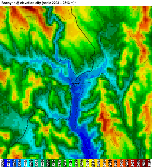
Below is the Elevation map of Bocoyna, which displays elevation range with different colors. Scale of the first map is from 2203 to 2513 m (7228 to 8245 ft) with average elevation of 2328.7 meters (=7640 ft) [note 1]
These maps also provides idea of topography and contour of this city, they are displayed at different zoom levels. More info about maps, scale and edge coordinates you can find below images.
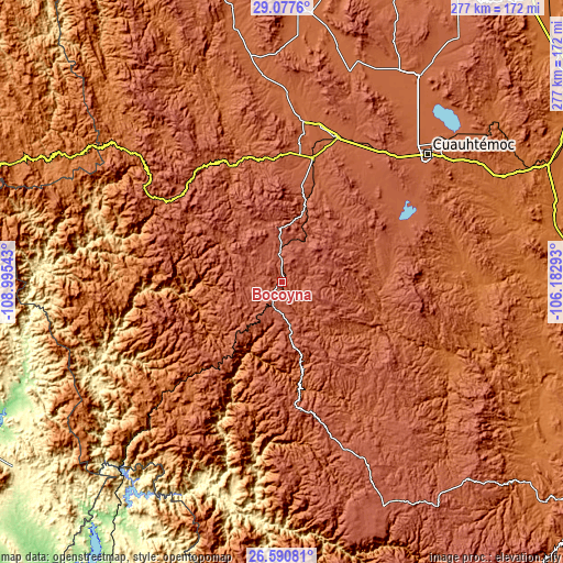
| \ | Map #1 | Topo.Map |
| Scale [m] | 2203..2513 m | × |
| Scale [ft] | 7228..8245 ft | × |
| Average | 2328.7 m = 7640 ft | × |
| Width | 8.64 km = 5.4 mi | 276.5 km = 171.8 mi |
| Height | 8.64 km = 5.4 mi | 276.5 km = 171.8 mi |
| ↑Max Latitude | 27.880181° | 29.0776° |
| Latitude at center | 27.84133° | 27.84133° |
| ↓Min Latitude | 27.802465° | 26.59081° |
| ← Min Longitude | -107.633125° | -108.99543° |
| Longitude center | -107.58918° | -107.58918° |
| →Max Longitude | -107.545235° | -106.18293° |
Nearby cities:
Cities around Bocoyna sort by population:
• San Juanito elevation 2405 m
14.7 km,  355°
355°
• Adolfo López Mateos 2097 m
75.1 km,  22°
22°
• Creel 2346 m
11.1 km,  204°
204°
• Tomochic 1933 m
62.2 km,  336°
336°
• San Rafael 2174 m
48.4 km,  217°
217°
• Carichí 2075 m
53 km,  80°
80°
• Bahuichivo 1639 m
67.3 km, 224°
• Basaseachic 2000 m
73.4 km,  303°
303°
• Samachique 2143 m
60.2 km,  175°
175°
• Uruachi 1356 m
61.6 km,  272°
272°
• Sisoguichi 2212 m
11.3 km,  125°
125°
• Maguarichi 1676 m
39.8 km, 272°
Multilingual:
 En español:
Bocoyna elevación 2231 m.
 En France:
Bocoyna élévation 2231 m.
 Auf Deutsch:
Bocoyna höhe über dem Meeresspiegel ist 2231 m.

Sources and notes:
- [note 1] Map square and city borders are not equal. Map elevation data is calculated only from area inside that square.
- [src 1] Elevation data from geonames database provided with same terms of usage.
- [src 2] The elevation map of Bocoyna is generated using elevation data from NASA's 3 arcsec (90m) resolution SRTM data.
- [src 3] Base (background) map © OpenStreetMap contributors tiles are generated by Geofabrik and OpenTopoMap.
Copyright & License:
This Bocoyna Elevation Map is licensed under CC BY-SA. You may reuse any part from this page, if you give a proper credit by linking to this URL:
 More info on terms of use page.