San Juanito elevation
San Juanito (Chihuahua, Bocoyna), Mexico elevation is 2405 meters and San Juanito elevation in feet is 7890 ft above sea level [src 1]. San Juanito is a populated place (feature code) with elevation that is 1091 meters (3579 ft) bigger than average city elevation in Mexico.
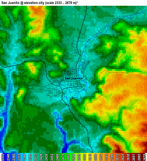
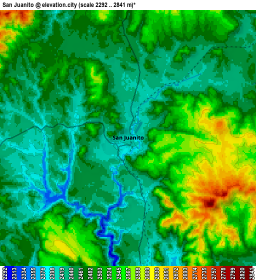
Below is the Elevation map of San Juanito, which displays elevation range with different colors. Scale of the first map is from 2333 to 2678 m (7654 to 8786 ft) with average elevation of 2460.9 meters (=8074 ft) [note 1]
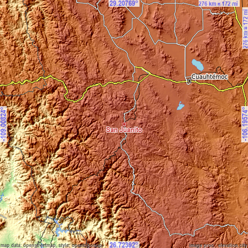
These maps also provides idea of topography and contour of this city, they are displayed at different zoom levels. More info about maps, scale and edge coordinates you can find below images.
| \ | Map #1 | Map #2 | Topo.Map |
| Scale [m] | 2333..2678 m | 2292..2841 m | × |
| Scale [ft] | 7654..8786 ft | 7520..9321 ft | × |
| Average | 2460.9 m = 8074 ft | 2485.2 m = 8154 ft | × |
| Width | 8.63 km = 5.4 mi | 17.26 km = 10.7 mi | 276.2 km = 171.6 mi |
| Height | 8.63 km = 5.4 mi | 17.26 km = 10.7 mi | 276.2 km = 171.6 mi |
| ↑Max Latitude | 28.011754° | 28.050544° | 29.20769° |
| Latitude at center | 27.97295° | 27.97295° | 27.97295° |
| ↓Min Latitude | 27.934132° | 27.8953° | 26.72392° |
| ← Min Longitude | -107.645935° | -107.689881° | -109.00824° |
| Longitude center | -107.60199° | -107.60199° | -107.60199° |
| →Max Longitude | -107.558045° | -107.514099° | -106.19574° |
Nearby cities:
Cities around San Juanito sort by population:
• La Junta elevation 2078 m
62.4 km,  25°
25°
• Adolfo López Mateos 2097 m
62.4 km, 28°
• Guerrero 2004 m
65.1 km,  10°
10°
• Creel 2346 m
24.9 km,  187°
187°
• Tomochic 1933 m
48.5 km,  330°
330°
• San Rafael 2174 m
60 km,  208°
208°
• Carichí 2075 m
53.9 km,  96°
96°
• Basúchil 2036 m
64.4 km,  17°
17°
• Uruachi 1356 m
61.4 km,  258°
258°
• Sisoguichi 2212 m
23.6 km,  153°
153°
• Maguarichi 1676 m
40.5 km,  251°
251°
• Bocoyna 2231 m
14.7 km,  175°
175°
Multilingual:
 En español:
San Juanito elevación 2405 m.
 En France:
San Juanito élévation 2405 m.
 Auf Deutsch:
San Juanito höhe über dem Meeresspiegel ist 2405 m.

Sources and notes:
- [note 1] Map square and city borders are not equal. Map elevation data is calculated only from area inside that square.
- [src 1] Elevation data from geonames database provided with same terms of usage.
- [src 2] The elevation map of San Juanito is generated using elevation data from NASA's 3 arcsec (90m) resolution SRTM data.
- [src 3] Base (background) map © OpenStreetMap contributors tiles are generated by Geofabrik and OpenTopoMap.
Copyright & License:
This San Juanito Elevation Map is licensed under CC BY-SA. You may reuse any part from this page, if you give a proper credit by linking to this URL:
 More info on terms of use page.