Guerrero elevation
Guerrero (Chihuahua), Mexico elevation is 2004 meters and Guerrero elevation in feet is 6575 ft above sea level [src 1]. Guerrero is a seat of a second-order administrative division (feature code) with elevation that is 690 meters (2264 ft) bigger than average city elevation in Mexico.
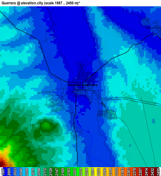
Below is the Elevation map of Guerrero, which displays elevation range with different colors. Scale of the first map is from 1987 to 2450 m (6519 to 8038 ft) with average elevation of 2050.4 meters (=6727 ft) [note 1]
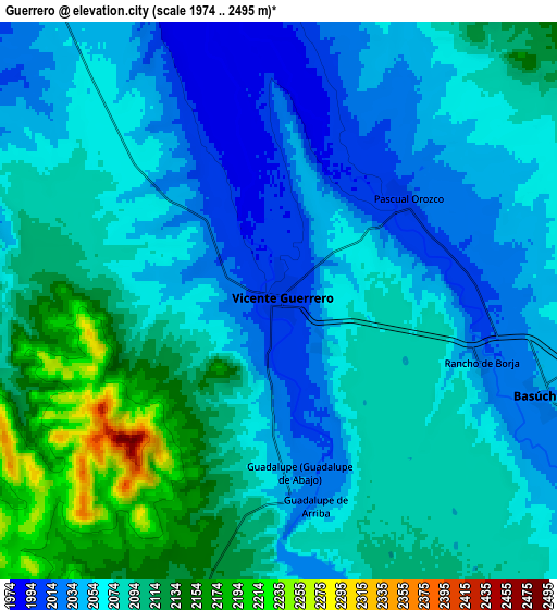
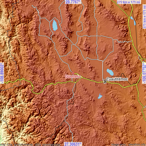
These maps also provides idea of topography and contour of this city, they are displayed at different zoom levels. More info about maps, scale and edge coordinates you can find below images.
| \ | Map #1 | Map #2 | Topo.Map |
| Scale [m] | 1987..2450 m | 1974..2495 m | × |
| Scale [ft] | 6519..8038 ft | 6476..8186 ft | × |
| Average | 2050.4 m = 6727 ft | 2076.8 m = 6814 ft | × |
| Width | 8.58 km = 5.3 mi | 17.17 km = 10.7 mi | 274.7 km = 170.7 mi |
| Height | 8.58 km = 5.3 mi | 17.17 km = 10.7 mi | 274.7 km = 170.7 mi |
| ↑Max Latitude | 28.587345° | 28.625926° | 29.7767° |
| Latitude at center | 28.54875° | 28.54875° | 28.54875° |
| ↓Min Latitude | 28.510141° | 28.471518° | 27.30631° |
| ← Min Longitude | -107.527715° | -107.571661° | -108.89002° |
| Longitude center | -107.48377° | -107.48377° | -107.48377° |
| →Max Longitude | -107.439825° | -107.395879° | -106.07752° |
Nearby cities:
Cities around Guerrero sort by population:
• Cuauhtémoc elevation 2051 m
62.6 km,  104°
104°
• San Juanito 2405 m
65.1 km,  190°
190°
• La Junta 2078 m
16.9 km,  116°
116°
• Adolfo López Mateos 2097 m
20.1 km, 116°
• Oscar Soto Maynez 1880 m
53.5 km,  1°
1°
• Tomochic 1933 m
41.6 km,  238°
238°
• Bachíniva 2021 m
33 km,  42°
42°
• Temósachic 1869 m
56.3 km,  323°
323°
• Matachí 1899 m
42.1 km, 321°
• Basúchil 2036 m
8.4 km,  108°
108°
• Ejido La Quemada 2038 m
56 km,  53°
53°
• Independencia 1951 m
60.7 km,  354°
354°
Multilingual:
 En español:
Vicente Guerrero elevación 2004 m.
 En France:
Guerrero élévation 2004 m.
 Auf Deutsch:
Guerrero höhe über dem Meeresspiegel ist 2004 m.

Sources and notes:
- [note 1] Map square and city borders are not equal. Map elevation data is calculated only from area inside that square.
- [src 1] Elevation data from geonames database provided with same terms of usage.
- [src 2] The elevation map of Guerrero is generated using elevation data from NASA's 3 arcsec (90m) resolution SRTM data.
- [src 3] Base (background) map © OpenStreetMap contributors tiles are generated by Geofabrik and OpenTopoMap.
Copyright & License:
This Guerrero Elevation Map is licensed under CC BY-SA. You may reuse any part from this page, if you give a proper credit by linking to this URL:
 More info on terms of use page.