San Francisco de Borja elevation
San Francisco de Borja (Chihuahua), Mexico elevation is 1646 meters and San Francisco de Borja elevation in feet is 5400 ft above sea level [src 1]. San Francisco de Borja is a seat of a second-order administrative division (feature code) with elevation that is 332 meters (1089 ft) bigger than average city elevation in Mexico.
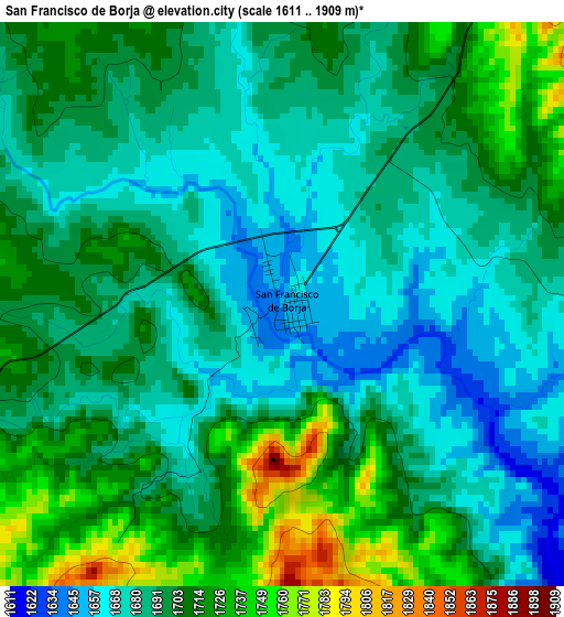
Below is the Elevation map of San Francisco de Borja, which displays elevation range with different colors. Scale of the first map is from 1611 to 1909 m (5285 to 6263 ft) with average elevation of 1695.6 meters (=5563 ft) [note 1]
These maps also provides idea of topography and contour of this city, they are displayed at different zoom levels. More info about maps, scale and edge coordinates you can find below images.
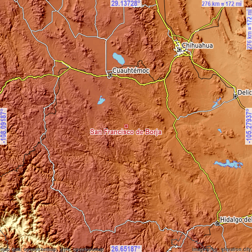
| \ | Map #1 | Topo.Map |
| Scale [m] | 1611..1909 m | × |
| Scale [ft] | 5285..6263 ft | × |
| Average | 1695.6 m = 5563 ft | × |
| Width | 8.64 km = 5.4 mi | 276.4 km = 171.7 mi |
| Height | 8.64 km = 5.4 mi | 276.4 km = 171.7 mi |
| ↑Max Latitude | 27.94054° | 29.13728° |
| Latitude at center | 27.90171° | 27.90171° |
| ↓Min Latitude | 27.862866° | 26.65187° |
| ← Min Longitude | -106.729565° | -108.09187° |
| Longitude center | -106.68562° | -106.68562° |
| →Max Longitude | -106.641675° | -105.27937° |
Nearby cities:
Cities around San Francisco de Borja sort by population:
• Cuauhtémoc elevation 2051 m
59 km,  342°
342°
• Anáhuac 1981 m
65 km,  354°
354°
• Valentín Gómez Farías 1739 m
36.4 km,  15°
15°
• Carichí 2075 m
36.5 km,  272°
272°
• Santa Isabel 1623 m
57.8 km,  32°
32°
• Nonoava 1643 m
47.9 km,  185°
185°
• Sisoguichi 2212 m
80.7 km,  260°
260°
• Carretas 1676 m
42.3 km, 23°
• San Andrés 1764 m
74 km,  13°
13°
• San Lorenzo 1602 m
34.7 km,  36°
36°
• Valle del Rosario 1477 m
75.4 km,  149°
149°
• Cusihuiriachi 2000 m
40.3 km, 338°
Multilingual:
 En español:
San Francisco de Borja elevación 1646 m.
 En France:
San Francisco de Borja élévation 1646 m.
 Auf Deutsch:
San Francisco de Borja höhe über dem Meeresspiegel ist 1646 m.
 На русском:
San Francisco de Borja высота над уровнем моря 1646 м
Sources and notes:
- [note 1] Map square and city borders are not equal. Map elevation data is calculated only from area inside that square.
- [src 1] Elevation data from geonames database provided with same terms of usage.
- [src 2] The elevation map of San Francisco de Borja is generated using elevation data from NASA's 3 arcsec (90m) resolution SRTM data.
- [src 3] Base (background) map © OpenStreetMap contributors tiles are generated by Geofabrik and OpenTopoMap.
Copyright & License:
This San Francisco de Borja Elevation Map is licensed under CC BY-SA. You may reuse any part from this page, if you give a proper credit by linking to this URL:
 More info on terms of use page.