Potrerillos elevation
Potrerillos (Jalisco, Jocotepec), Mexico elevation is 1844 meters and Potrerillos elevation in feet is 6050 ft above sea level [src 1]. Potrerillos is a populated place (feature code) with elevation that is 530 meters (1739 ft) bigger than average city elevation in Mexico.
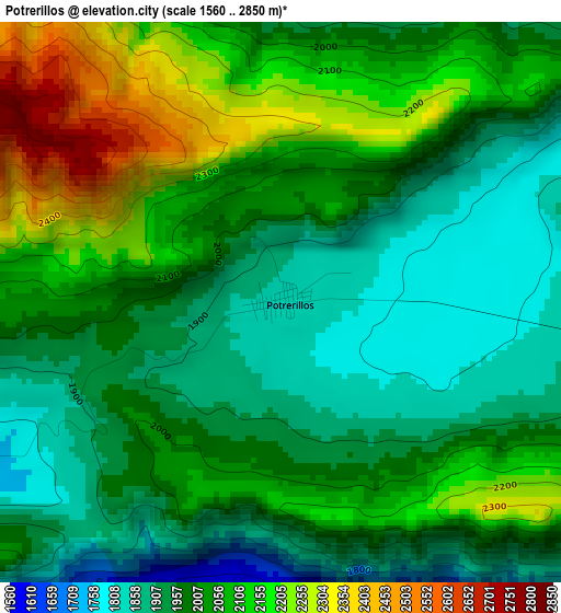
Below is the Elevation map of Potrerillos, which displays elevation range with different colors. Scale of the first map is from 1560 to 2850 m (5118 to 9350 ft) with average elevation of 2017.9 meters (=6620 ft) [note 1]
These maps also provides idea of topography and contour of this city, they are displayed at different zoom levels. More info about maps, scale and edge coordinates you can find below images.
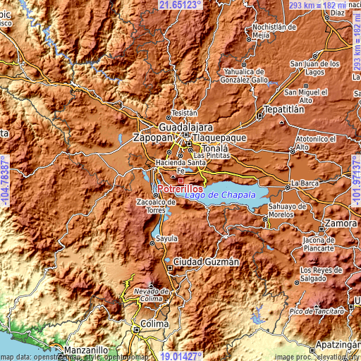
| \ | Map #1 | Topo.Map |
| Scale [m] | 1560..2850 m | × |
| Scale [ft] | 5118..9350 ft | × |
| Average | 2017.9 m = 6620 ft | × |
| Width | 9.16 km = 5.7 mi | 293.2 km = 182.2 mi |
| Height | 9.16 km = 5.7 mi | 293.2 km = 182.2 mi |
| ↑Max Latitude | 20.37957° | 21.65123° |
| Latitude at center | 20.33837° | 20.33837° |
| ↓Min Latitude | 20.297159° | 19.01427° |
| ← Min Longitude | -103.421565° | -104.78387° |
| Longitude center | -103.37762° | -103.37762° |
| →Max Longitude | -103.333675° | -101.97137° |
Nearby cities:
Cities around Potrerillos sort by population:
• Jocotepec elevation 1544 m
8 km,  222°
222°
• Ajijic 1577 m
13.4 km,  106°
106°
• San Miguel Cuyutlán 1585 m
8.8 km,  351°
351°
• San Juan Cosalá 1536 m
6.8 km,  146°
146°
• Galaxia la Noria 1565 m
13.9 km,  341°
341°
• Cajititlán 1569 m
12.6 km,  34°
34°
• Zapotitán de Hidalgo 1599 m
10.6 km,  262°
262°
• San Lucas Evangelista 1579 m
8 km,  12°
12°
• San Cristóbal Zapotitlán 1538 m
12.7 km,  176°
176°
• Cuexcomatitlán 1560 m
10.1 km, 9°
• San Pedro Tesistán 1555 m
13 km,  197°
197°
• Huejotitán 1594 m
11.6 km,  279°
279°
Multilingual:
 En español:
Potrerillos elevación 1844 m.
 En France:
Potrerillos élévation 1844 m.
 Auf Deutsch:
Potrerillos höhe über dem Meeresspiegel ist 1844 m.

Sources and notes:
- [note 1] Map square and city borders are not equal. Map elevation data is calculated only from area inside that square.
- [src 1] Elevation data from geonames database provided with same terms of usage.
- [src 2] The elevation map of Potrerillos is generated using elevation data from NASA's 3 arcsec (90m) resolution SRTM data.
- [src 3] Base (background) map © OpenStreetMap contributors tiles are generated by Geofabrik and OpenTopoMap.
Copyright & License:
This Potrerillos Elevation Map is licensed under CC BY-SA. You may reuse any part from this page, if you give a proper credit by linking to this URL:
 More info on terms of use page.