Cajititlán elevation
Cajititlán (Jalisco, Tlajomulco de Zúñiga), Mexico elevation is 1569 meters and Cajititlán elevation in feet is 5148 ft above sea level [src 1]. Cajititlán is a populated place (feature code) with elevation that is 255 meters (837 ft) bigger than average city elevation in Mexico.
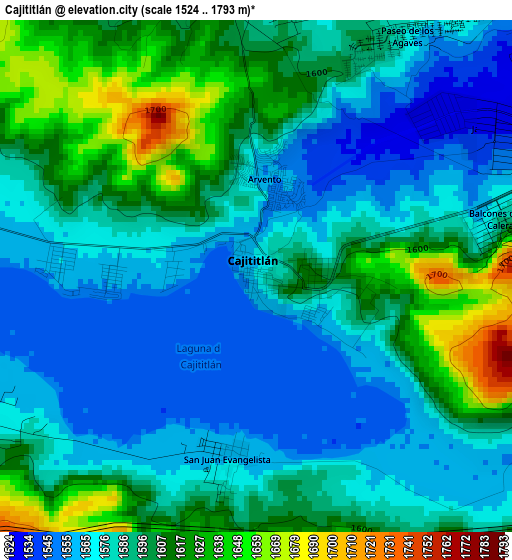
Below is the Elevation map of Cajititlán, which displays elevation range with different colors. Scale of the first map is from 1524 to 1793 m (5000 to 5883 ft) with average elevation of 1589.7 meters (=5216 ft) [note 1]
These maps also provides idea of topography and contour of this city, they are displayed at different zoom levels. More info about maps, scale and edge coordinates you can find below images.
| \ | Map #1 | Map #2 | Topo.Map |
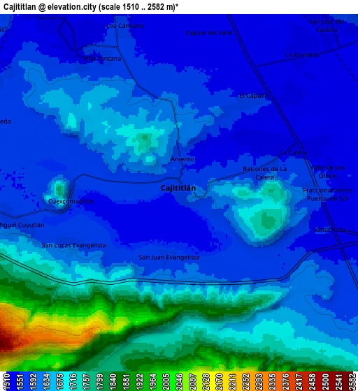
| Scale [m] | 1524..1793 m | 1510..2582 m | × |
| Scale [ft] | 5000..5883 ft | 4954..8471 ft | × |
| Average | 1589.7 m = 5216 ft | 1642.1 m = 5387 ft | × |
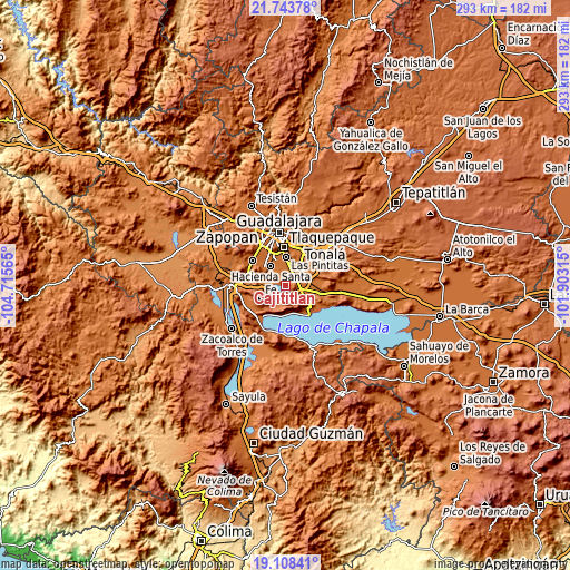
| Width | 9.16 km = 5.7 mi | 18.32 km = 11.4 mi | 293 km = 182.1 mi |
| Height | 9.16 km = 5.7 mi | 18.32 km = 11.4 mi | 293 km = 182.1 mi |
| ↑Max Latitude | 20.472915° | 20.514079° | 21.74378° |
| Latitude at center | 20.43174° | 20.43174° | 20.43174° |
| ↓Min Latitude | 20.390554° | 20.349357° | 19.10841° |
| ← Min Longitude | -103.353345° | -103.397291° | -104.71565° |
| Longitude center | -103.3094° | -103.3094° | -103.3094° |
| →Max Longitude | -103.265455° | -103.221509° | -101.90315° |
Nearby cities:
Cities around Cajititlán sort by population:
• La Alameda elevation 1522 m
9.5 km,  42°
42°
• Capulín 1543 m
6.6 km, 38°
• Rancho Alegre [Fraccionamiento] 1537 m
7.1 km,  49°
49°
• Los Olivos 1549 m
7.5 km,  83°
83°
• San Miguel Cuyutlán 1585 m
8.6 km,  258°
258°
• Lomas de Tejeda 1573 m
10.4 km,  291°
291°
• San Lucas Evangelista 1579 m
6 km,  243°
243°
• Rinconada la Loma [Fraccionamiento] 1531 m
9.7 km, 75°
• Los Cedros 1575 m
9.3 km,  120°
120°
• La Calera 1529 m
6.3 km,  69°
69°
• Cuexcomatitlán 1560 m
5.5 km,  265°
265°
• Santa Rosa 1550 m
8 km,  104°
104°
Multilingual:
 En español:
Cajititlán elevación 1569 m.
 En France:
Cajititlán élévation 1569 m.
 Auf Deutsch:
Cajititlán höhe über dem Meeresspiegel ist 1569 m.

Sources and notes:
- [note 1] Map square and city borders are not equal. Map elevation data is calculated only from area inside that square.
- [src 1] Elevation data from geonames database provided with same terms of usage.
- [src 2] The elevation map of Cajititlán is generated using elevation data from NASA's 3 arcsec (90m) resolution SRTM data.
- [src 3] Base (background) map © OpenStreetMap contributors tiles are generated by Geofabrik and OpenTopoMap.
Copyright & License:
This Cajititlán Elevation Map is licensed under CC BY-SA. You may reuse any part from this page, if you give a proper credit by linking to this URL:
 More info on terms of use page.