Huejotitán elevation
Huejotitán (Jalisco, Jocotepec), Mexico elevation is 1594 meters and Huejotitán elevation in feet is 5230 ft above sea level [src 1]. Huejotitán is a populated place (feature code) with elevation that is 280 meters (919 ft) bigger than average city elevation in Mexico.
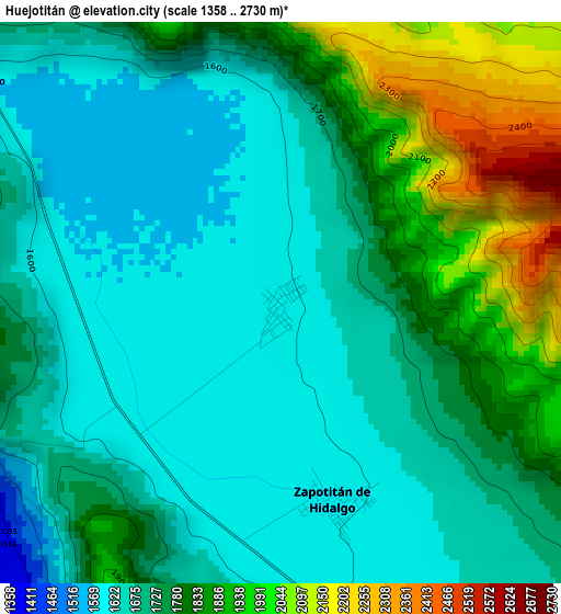
Below is the Elevation map of Huejotitán, which displays elevation range with different colors. Scale of the first map is from 1358 to 2730 m (4455 to 8957 ft) with average elevation of 1743.8 meters (=5721 ft) [note 1]
These maps also provides idea of topography and contour of this city, they are displayed at different zoom levels. More info about maps, scale and edge coordinates you can find below images.
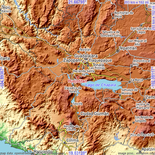
| \ | Map #1 | Topo.Map |
| Scale [m] | 1358..2730 m | × |
| Scale [ft] | 4455..8957 ft | × |
| Average | 1743.8 m = 5721 ft | × |
| Width | 9.16 km = 5.7 mi | 293.2 km = 182.2 mi |
| Height | 9.16 km = 5.7 mi | 293.2 km = 182.2 mi |
| ↑Max Latitude | 20.396436° | 21.66795° |
| Latitude at center | 20.35524° | 20.35524° |
| ↓Min Latitude | 20.314033° | 19.03128° |
| ← Min Longitude | -103.531365° | -104.89367° |
| Longitude center | -103.48742° | -103.48742° |
| →Max Longitude | -103.443475° | -102.08117° |
Nearby cities:
Cities around Huejotitán sort by population:
• Tlajomulco de Zúñiga elevation 1586 m
13.9 km,  17°
17°
• Jocotepec 1544 m
9.9 km,  141°
141°
• Acatlán de Juárez 1371 m
13.1 km,  304°
304°
• San Miguel Cuyutlán 1585 m
12.2 km,  56°
56°
• Galaxia la Noria 1565 m
13.4 km,  32°
32°
• Zapotitán de Hidalgo 1599 m
3.3 km,  163°
163°
• Buenavista 1511 m
11.6 km,  342°
342°
• General Andrés Figueroa 1358 m
13.9 km,  245°
245°
• El Molino 1577 m
6.2 km,  306°
306°
• Potrerillos 1844 m
11.6 km,  99°
99°
• Villa de los Niños 1639 m
8 km,  315°
315°
• San Marcos 1358 m
6.3 km,  230°
230°
Multilingual:
 En español:
Huejotitán elevación 1594 m.
 En France:
Huejotitán élévation 1594 m.
 Auf Deutsch:
Huejotitán höhe über dem Meeresspiegel ist 1594 m.

Sources and notes:
- [note 1] Map square and city borders are not equal. Map elevation data is calculated only from area inside that square.
- [src 1] Elevation data from geonames database provided with same terms of usage.
- [src 2] The elevation map of Huejotitán is generated using elevation data from NASA's 3 arcsec (90m) resolution SRTM data.
- [src 3] Base (background) map © OpenStreetMap contributors tiles are generated by Geofabrik and OpenTopoMap.
Copyright & License:
This Huejotitán Elevation Map is licensed under CC BY-SA. You may reuse any part from this page, if you give a proper credit by linking to this URL:
 More info on terms of use page.