Acatlán de Juárez elevation
Acatlán de Juárez (Jalisco), Mexico elevation is 1371 meters and Acatlán de Juárez elevation in feet is 4498 ft above sea level [src 1]. Acatlán de Juárez is a seat of a second-order administrative division (feature code) with elevation that is 57 meters (187 ft) bigger than average city elevation in Mexico.
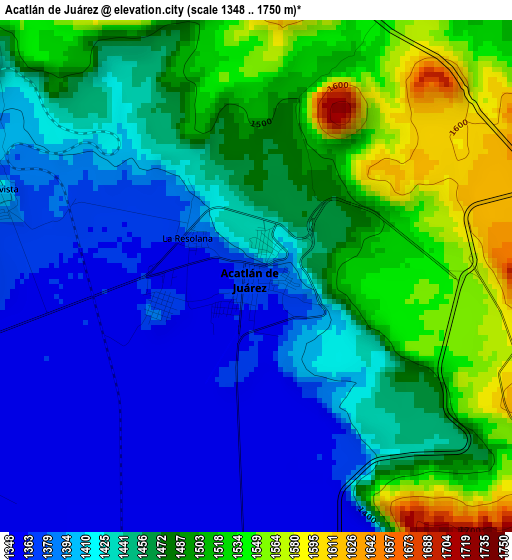
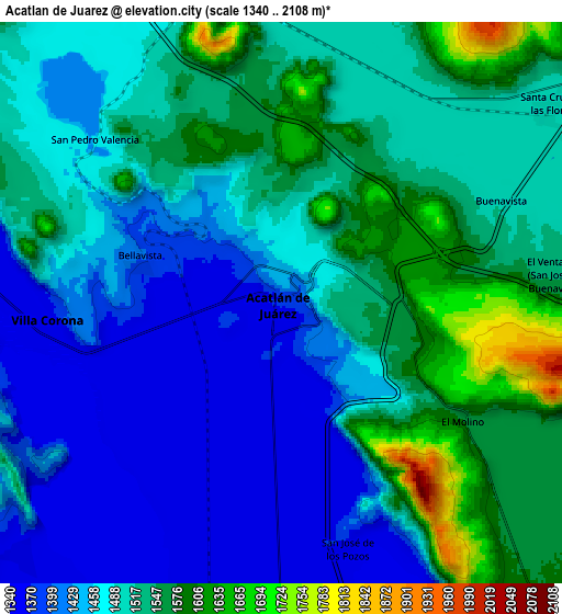
Below is the Elevation map of Acatlán de Juárez, which displays elevation range with different colors. Scale of the first map is from 1348 to 1750 m (4423 to 5741 ft) with average elevation of 1452.8 meters (=4766 ft) [note 1]
These maps also provides idea of topography and contour of this city, they are displayed at different zoom levels. More info about maps, scale and edge coordinates you can find below images.
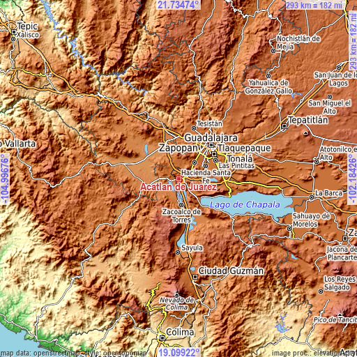
| \ | Map #1 | Map #2 | Topo.Map |
| Scale [m] | 1348..1750 m | 1340..2108 m | × |
| Scale [ft] | 4423..5741 ft | 4396..6916 ft | × |
| Average | 1452.8 m = 4766 ft | 1492.5 m = 4897 ft | × |
| Width | 9.16 km = 5.7 mi | 18.32 km = 11.4 mi | 293 km = 182.1 mi |
| Height | 9.16 km = 5.7 mi | 18.32 km = 11.4 mi | 293.1 km = 182.1 mi |
| ↑Max Latitude | 20.463798° | 20.504964° | 21.73474° |
| Latitude at center | 20.42262° | 20.42262° | 20.42262° |
| ↓Min Latitude | 20.381431° | 20.340232° | 19.09922° |
| ← Min Longitude | -103.634455° | -103.678401° | -104.99676° |
| Longitude center | -103.59051° | -103.59051° | -103.59051° |
| →Max Longitude | -103.546565° | -103.502619° | -102.18426° |
Nearby cities:
Cities around Acatlán de Juárez sort by population:
• Santa Cruz de las Flores elevation 1513 m
11.2 km,  54°
54°
• Villa Corona 1359 m
7.7 km,  264°
264°
• Bellavista 1404 m
5.1 km,  284°
284°
• San Isidro Mazatepec 1486 m
11.4 km,  348°
348°
• Buenavista 1511 m
8.1 km,  63°
63°
• El Plan 1372 m
1.7 km,  254°
254°
• Atotonilco el Bajo 1357 m
11.8 km,  227°
227°
• El Molino 1577 m
6.9 km,  123°
123°
• Cofradia 1523 m
6.6 km,  30°
30°
• Villa de los Niños 1639 m
5.4 km,  109°
109°
• Santa Cruz de la Loma (Tepetates) 1510 m
8.4 km, 30°
• San Marcos 1358 m
12.9 km,  152°
152°
Multilingual:
 En español:
Acatlán de Juárez, Acatlán elevación 1371 m.
 En France:
Acatlán de Juárez élévation 1371 m.
 Auf Deutsch:
Acatlán de Juárez höhe über dem Meeresspiegel ist 1371 m.
 На русском:
Acatlán de Juárez высота над уровнем моря 1371 м
Sources and notes:
- [note 1] Map square and city borders are not equal. Map elevation data is calculated only from area inside that square.
- [src 1] Elevation data from geonames database provided with same terms of usage.
- [src 2] The elevation map of Acatlán de Juárez is generated using elevation data from NASA's 3 arcsec (90m) resolution SRTM data.
- [src 3] Base (background) map © OpenStreetMap contributors tiles are generated by Geofabrik and OpenTopoMap.
Copyright & License:
This Acatlán de Juárez Elevation Map is licensed under CC BY-SA. You may reuse any part from this page, if you give a proper credit by linking to this URL:
 More info on terms of use page.