Bellavista elevation
Bellavista (Jalisco, Acatlán de Juárez), Mexico elevation is 1404 meters and Bellavista elevation in feet is 4606 ft above sea level [src 1]. Bellavista is a populated place (feature code) with elevation that is 90 meters (295 ft) bigger than average city elevation in Mexico.
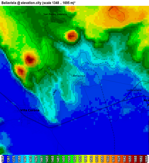
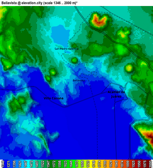
Below is the Elevation map of Bellavista, which displays elevation range with different colors. Scale of the first map is from 1348 to 1695 m (4423 to 5561 ft) with average elevation of 1425.1 meters (=4676 ft) [note 1]
These maps also provides idea of topography and contour of this city, they are displayed at different zoom levels. More info about maps, scale and edge coordinates you can find below images.
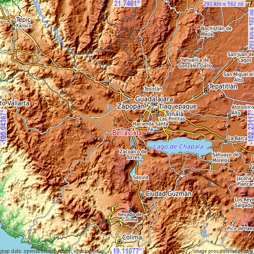
| \ | Map #1 | Map #2 | Topo.Map |
| Scale [m] | 1348..1695 m | 1346..2000 m | × |
| Scale [ft] | 4423..5561 ft | 4416..6562 ft | × |
| Average | 1425.1 m = 4676 ft | 1460.5 m = 4792 ft | × |
| Width | 9.16 km = 5.7 mi | 18.32 km = 11.4 mi | 293 km = 182.1 mi |
| Height | 9.16 km = 5.7 mi | 18.32 km = 11.4 mi | 293 km = 182.1 mi |
| ↑Max Latitude | 20.475255° | 20.516418° | 21.7461° |
| Latitude at center | 20.43408° | 20.43408° | 20.43408° |
| ↓Min Latitude | 20.392894° | 20.351698° | 19.11077° |
| ← Min Longitude | -103.681365° | -103.725311° | -105.04367° |
| Longitude center | -103.63742° | -103.63742° | -103.63742° |
| →Max Longitude | -103.593475° | -103.549529° | -102.23117° |
Nearby cities:
Cities around Bellavista sort by population:
• Acatlán de Juárez elevation 1371 m
5.1 km,  104°
104°
• Villa Corona 1359 m
3.5 km,  233°
233°
• San Isidro Mazatepec 1486 m
10.2 km,  14°
14°
• El Plan 1372 m
3.6 km,  118°
118°
• Estipa 1379 m
12 km, 228°
• Atotonilco el Bajo 1357 m
10 km,  202°
202°
• Juan Gil Preciado 1389 m
11.6 km, 233°
• Navajas 1482 m
11.9 km,  338°
338°
• El Molino 1577 m
11.8 km, 115°
• Cofradia 1523 m
9.3 km,  62°
62°
• Villa de los Niños 1639 m
10.4 km,  106°
106°
• Santa Cruz de la Loma (Tepetates) 1510 m
10.9 km, 56°
Multilingual:
 En español:
Bellavista elevación 1404 m.
 En France:
Bellavista élévation 1404 m.
 Auf Deutsch:
Bellavista höhe über dem Meeresspiegel ist 1404 m.

Sources and notes:
- [note 1] Map square and city borders are not equal. Map elevation data is calculated only from area inside that square.
- [src 1] Elevation data from geonames database provided with same terms of usage.
- [src 2] The elevation map of Bellavista is generated using elevation data from NASA's 3 arcsec (90m) resolution SRTM data.
- [src 3] Base (background) map © OpenStreetMap contributors tiles are generated by Geofabrik and OpenTopoMap.
Copyright & License:
This Bellavista Elevation Map is licensed under CC BY-SA. You may reuse any part from this page, if you give a proper credit by linking to this URL:
 More info on terms of use page.