Navajas elevation
Navajas (Jalisco, Tala), Mexico elevation is 1482 meters and Navajas elevation in feet is 4862 ft above sea level [src 1]. Navajas is a populated place (feature code) with elevation that is 168 meters (551 ft) bigger than average city elevation in Mexico.
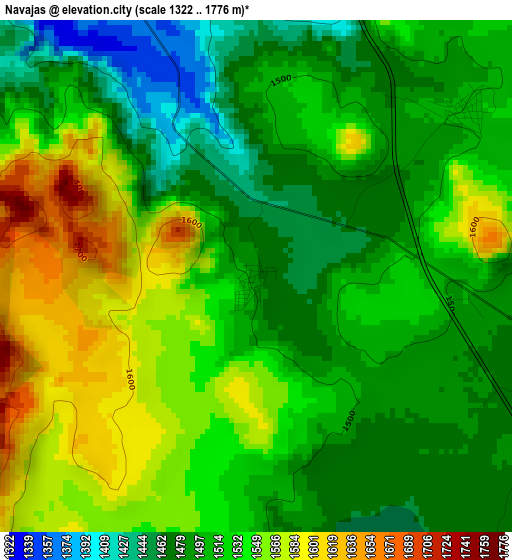
Below is the Elevation map of Navajas, which displays elevation range with different colors. Scale of the first map is from 1322 to 1776 m (4337 to 5827 ft) with average elevation of 1519.4 meters (=4985 ft) [note 1]
These maps also provides idea of topography and contour of this city, they are displayed at different zoom levels. More info about maps, scale and edge coordinates you can find below images.
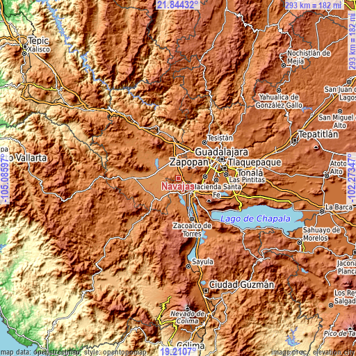
| \ | Map #1 | Topo.Map |
| Scale [m] | 1322..1776 m | × |
| Scale [ft] | 4337..5827 ft | × |
| Average | 1519.4 m = 4985 ft | × |
| Width | 9.15 km = 5.7 mi | 292.8 km = 181.9 mi |
| Height | 9.15 km = 5.7 mi | 292.8 km = 181.9 mi |
| ↑Max Latitude | 20.574328° | 21.84432° |
| Latitude at center | 20.53318° | 20.53318° |
| ↓Min Latitude | 20.492021° | 19.2107° |
| ← Min Longitude | -103.723665° | -105.08597° |
| Longitude center | -103.67972° | -103.67972° |
| →Max Longitude | -103.635775° | -102.27347° |
Nearby cities:
Cities around Navajas sort by population:
• Tala elevation 1338 m
13.6 km,  350°
350°
• Villa Corona 1359 m
13.2 km,  172°
172°
• Bellavista 1404 m
11.9 km,  158°
158°
• Cuisillos 1275 m
13 km,  310°
310°
• San Isidro Mazatepec 1486 m
7 km,  99°
99°
• El Plan 1372 m
14.9 km,  149°
149°
• Ahuisculco 1337 m
4.6 km,  328°
328°
• Cofradia 1523 m
14.3 km,  117°
117°
• San Juan de los Arcos 1308 m
9 km, 332°
• Cuxpala 1508 m
4.6 km,  51°
51°
• Santa Cruz de la Loma (Tepetates) 1510 m
14.4 km,  110°
110°
• Trapiche de Abra 1260 m
14.6 km,  272°
272°
Multilingual:
 En español:
Navajas elevación 1482 m.
 En France:
Navajas élévation 1482 m.
 Auf Deutsch:
Navajas höhe über dem Meeresspiegel ist 1482 m.

Sources and notes:
- [note 1] Map square and city borders are not equal. Map elevation data is calculated only from area inside that square.
- [src 1] Elevation data from geonames database provided with same terms of usage.
- [src 2] The elevation map of Navajas is generated using elevation data from NASA's 3 arcsec (90m) resolution SRTM data.
- [src 3] Base (background) map © OpenStreetMap contributors tiles are generated by Geofabrik and OpenTopoMap.
Copyright & License:
This Navajas Elevation Map is licensed under CC BY-SA. You may reuse any part from this page, if you give a proper credit by linking to this URL:
 More info on terms of use page.