Tala elevation
Tala (Jalisco), Mexico elevation is 1338 meters and Tala elevation in feet is 4390 ft above sea level [src 1]. Tala is a seat of a second-order administrative division (feature code) with elevation that is 24 meters (79 ft) bigger than average city elevation in Mexico.
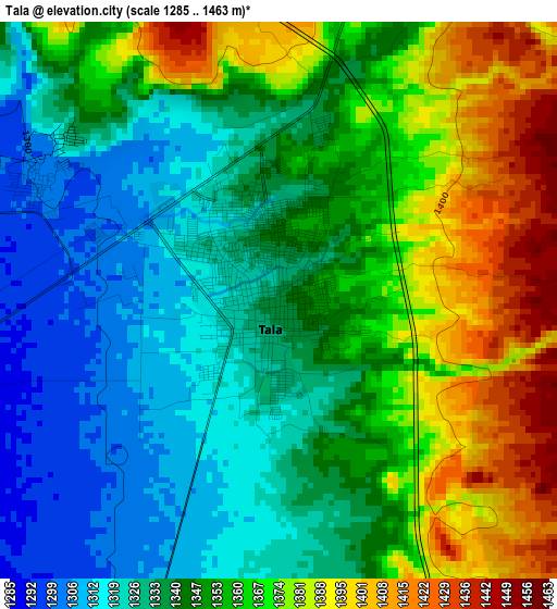
Below is the Elevation map of Tala, which displays elevation range with different colors. Scale of the first map is from 1285 to 1463 m (4216 to 4800 ft) with average elevation of 1350.9 meters (=4432 ft) [note 1]
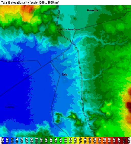
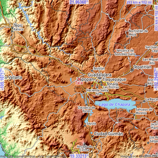
These maps also provides idea of topography and contour of this city, they are displayed at different zoom levels. More info about maps, scale and edge coordinates you can find below images.
| \ | Map #1 | Map #2 | Topo.Map |
| Scale [m] | 1285..1463 m | 1266..1835 m | × |
| Scale [ft] | 4216..4800 ft | 4154..6020 ft | × |
| Average | 1350.9 m = 4432 ft | 1401.7 m = 4599 ft | × |
| Width | 9.14 km = 5.7 mi | 18.29 km = 11.4 mi | 292.6 km = 181.8 mi |
| Height | 9.14 km = 5.7 mi | 18.29 km = 11.4 mi | 292.6 km = 181.8 mi |
| ↑Max Latitude | 20.694715° | 20.73582° | 21.96368° |
| Latitude at center | 20.6536° | 20.6536° | 20.6536° |
| ↓Min Latitude | 20.612473° | 20.571336° | 19.33213° |
| ← Min Longitude | -103.744865° | -103.788811° | -105.10717° |
| Longitude center | -103.70092° | -103.70092° | -103.70092° |
| →Max Longitude | -103.656975° | -103.613029° | -102.29467° |
Nearby cities:
Cities around Tala sort by population:
• El Arenal elevation 1389 m
13.6 km,  3°
3°
• Los Ruiseñores 1396 m
6.4 km,  8°
8°
• El Refugio 1302 m
4.5 km,  296°
296°
• Cuisillos 1275 m
9.1 km,  237°
237°
• Santa Cruz del Astillero 1437 m
12 km,  30°
30°
• Ahuisculco 1337 m
9.4 km,  181°
181°
• La Estanzuela 1264 m
13.1 km,  277°
277°
• Castro Urdiales 1275 m
13.9 km, 243°
• Huaxtla 1420 m
9.6 km,  24°
24°
• Navajas 1482 m
13.6 km,  170°
170°
• San Juan de los Arcos 1308 m
5.7 km,  199°
199°
• Cuxpala 1508 m
12 km,  150°
150°
Multilingual:
 En español:
Tala elevación 1338 m.
 En France:
Tala élévation 1338 m.


Sources and notes:
- [note 1] Map square and city borders are not equal. Map elevation data is calculated only from area inside that square.
- [src 1] Elevation data from geonames database provided with same terms of usage.
- [src 2] The elevation map of Tala is generated using elevation data from NASA's 3 arcsec (90m) resolution SRTM data.
- [src 3] Base (background) map © OpenStreetMap contributors tiles are generated by Geofabrik and OpenTopoMap.
Copyright & License:
This Tala Elevation Map is licensed under CC BY-SA. You may reuse any part from this page, if you give a proper credit by linking to this URL:
 More info on terms of use page.