Puruándiro elevation
Puruándiro (Michoacán), Mexico elevation is 1891 meters and Puruándiro elevation in feet is 6204 ft above sea level [src 1]. Puruándiro is a seat of a second-order administrative division (feature code) with elevation that is 577 meters (1893 ft) bigger than average city elevation in Mexico.
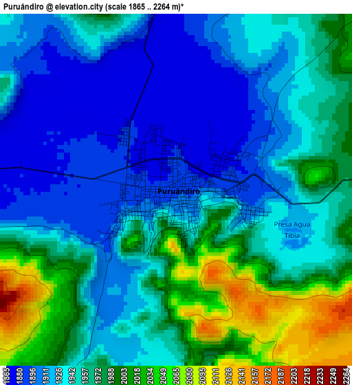
Below is the Elevation map of Puruándiro, which displays elevation range with different colors. Scale of the first map is from 1865 to 2264 m (6119 to 7428 ft) with average elevation of 1951.3 meters (=6402 ft) [note 1]
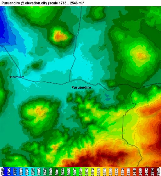
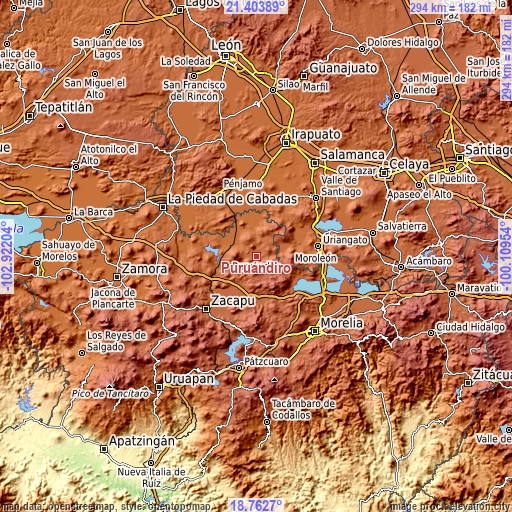
These maps also provides idea of topography and contour of this city, they are displayed at different zoom levels. More info about maps, scale and edge coordinates you can find below images.
| \ | Map #1 | Map #2 | Topo.Map |
| Scale [m] | 1865..2264 m | 1713..2546 m | × |
| Scale [ft] | 6119..7428 ft | 5620..8353 ft | × |
| Average | 1951.3 m = 6402 ft | 2026.6 m = 6649 ft | × |
| Width | 9.18 km = 5.7 mi | 18.36 km = 11.4 mi | 293.7 km = 182.5 mi |
| Height | 9.18 km = 5.7 mi | 18.36 km = 11.4 mi | 293.7 km = 182.5 mi |
| ↑Max Latitude | 20.130126° | 20.171382° | 21.40389° |
| Latitude at center | 20.08886° | 20.08886° | 20.08886° |
| ↓Min Latitude | 20.047583° | 20.006295° | 18.7627° |
| ← Min Longitude | -101.559735° | -101.603681° | -102.92204° |
| Longitude center | -101.51579° | -101.51579° | -101.51579° |
| →Max Longitude | -101.471845° | -101.427899° | -100.10954° |
Nearby cities:
Cities around Puruándiro sort by population:
• Cerano elevation 1882 m
13.6 km,  80°
80°
• Villachuato 1695 m
14.1 km,  298°
298°
• Galeana 1939 m
8.3 km,  224°
224°
• Santa Clara 1998 m
13.2 km,  40°
40°
• Villa Morelos 2290 m
14.3 km,  131°
131°
• San Martín 1690 m
17.3 km,  324°
324°
• Janamuato 1874 m
7.4 km,  279°
279°
• Manuel Villalongín 1716 m
16.6 km,  356°
356°
• San Lorenzo 1991 m
17.5 km,  230°
230°
• Tejocote de Calera 1985 m
15.9 km,  50°
50°
• Janambo 1823 m
13.1 km, 355°
• Las Ranas 2088 m
13.9 km,  16°
16°
Multilingual:
 En español:
Puruándiro elevación 1891 m.
 En France:
Puruándiro élévation 1891 m.
 Auf Deutsch:
Puruándiro höhe über dem Meeresspiegel ist 1891 m.

Sources and notes:
- [note 1] Map square and city borders are not equal. Map elevation data is calculated only from area inside that square.
- [src 1] Elevation data from geonames database provided with same terms of usage.
- [src 2] The elevation map of Puruándiro is generated using elevation data from NASA's 3 arcsec (90m) resolution SRTM data.
- [src 3] Base (background) map © OpenStreetMap contributors tiles are generated by Geofabrik and OpenTopoMap.
Copyright & License:
This Puruándiro Elevation Map is licensed under CC BY-SA. You may reuse any part from this page, if you give a proper credit by linking to this URL:
 More info on terms of use page.