Janambo elevation
Janambo (State of Mexico), Mexico elevation is 1823 meters and Janambo elevation in feet is 5981 ft above sea level [src 1]. Janambo is a populated place (feature code) with elevation that is 509 meters (1670 ft) bigger than average city elevation in Mexico.
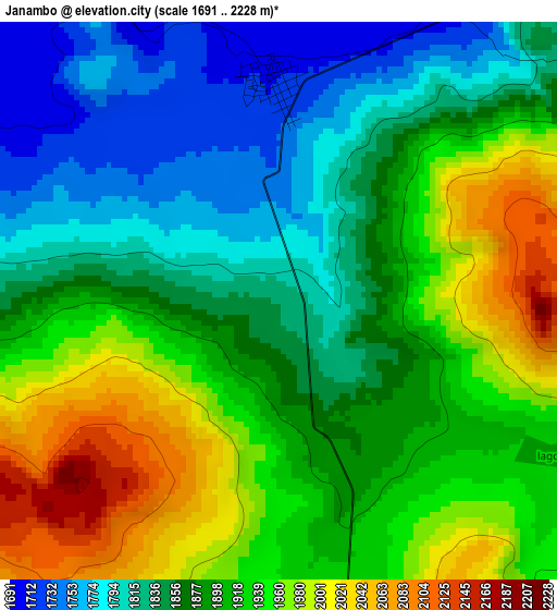
Below is the Elevation map of Janambo, which displays elevation range with different colors. Scale of the first map is from 1691 to 2228 m (5548 to 7310 ft) with average elevation of 1893 meters (=6211 ft) [note 1]
These maps also provides idea of topography and contour of this city, they are displayed at different zoom levels. More info about maps, scale and edge coordinates you can find below images.
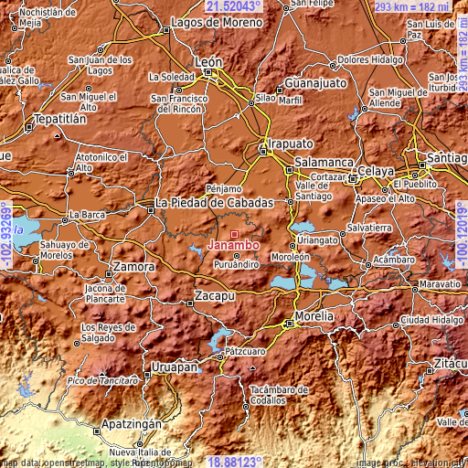
| \ | Map #1 | Topo.Map |
| Scale [m] | 1691..2228 m | × |
| Scale [ft] | 5548..7310 ft | × |
| Average | 1893 m = 6211 ft | × |
| Width | 9.17 km = 5.7 mi | 293.5 km = 182.4 mi |
| Height | 9.17 km = 5.7 mi | 293.5 km = 182.4 mi |
| ↑Max Latitude | 20.247655° | 21.52043° |
| Latitude at center | 20.20642° | 20.20642° |
| ↓Min Latitude | 20.165174° | 18.88123° |
| ← Min Longitude | -101.570385° | -102.93269° |
| Longitude center | -101.52644° | -101.52644° |
| →Max Longitude | -101.482495° | -100.12019° |
Nearby cities:
Cities around Janambo sort by population:
• Puruándiro elevation 1891 m
13.1 km,  175°
175°
• Villachuato 1695 m
13 km,  240°
240°
• San José Huipana 1718 m
9.9 km,  36°
36°
• Santa Clara 1998 m
10.2 km,  107°
107°
• San Martín 1690 m
8.9 km,  276°
276°
• Isaac Arriaga (Santa Ana Mancera) 1731 m
5.6 km, 38°
• Tres Mezquites 1690 m
12.2 km,  300°
300°
• Manuel Villalongín 1716 m
3.5 km,  359°
359°
• Héroes de Chapultepec (Rodeo de San Antonio) 1694 m
11.9 km,  12°
12°
• La Calera (Nacimientos) 1706 m
9.2 km,  326°
326°
• Las Letras 2132 m
10.1 km,  74°
74°
• Las Ranas 2088 m
5 km,  87°
87°
Multilingual:
 En español:
Janambo elevación 1823 m.
 En France:
Janambo élévation 1823 m.
 Auf Deutsch:
Janambo höhe über dem Meeresspiegel ist 1823 m.

Sources and notes:
- [note 1] Map square and city borders are not equal. Map elevation data is calculated only from area inside that square.
- [src 1] Elevation data from geonames database provided with same terms of usage.
- [src 2] The elevation map of Janambo is generated using elevation data from NASA's 3 arcsec (90m) resolution SRTM data.
- [src 3] Base (background) map © OpenStreetMap contributors tiles are generated by Geofabrik and OpenTopoMap.
Copyright & License:
This Janambo Elevation Map is licensed under CC BY-SA. You may reuse any part from this page, if you give a proper credit by linking to this URL:
 More info on terms of use page.