Rayones elevation
Rayones (Nuevo León), Mexico elevation is 853 meters and Rayones elevation in feet is 2799 ft above sea level [src 1]. Rayones is a seat of a second-order administrative division (feature code) with elevation that is 461 meters (1512 ft) smaller than average city elevation in Mexico.
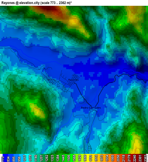
Below is the Elevation map of Rayones, which displays elevation range with different colors. Scale of the first map is from 773 to 2362 m (2536 to 7749 ft) with average elevation of 1124.7 meters (=3690 ft) [note 1]
These maps also provides idea of topography and contour of this city, they are displayed at different zoom levels. More info about maps, scale and edge coordinates you can find below images.
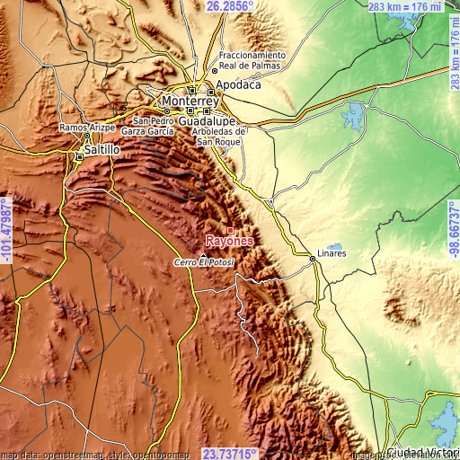
| \ | Map #1 | Topo.Map |
| Scale [m] | 773..2362 m | × |
| Scale [ft] | 2536..7749 ft | × |
| Average | 1124.7 m = 3690 ft | × |
| Width | 8.86 km = 5.5 mi | 283.4 km = 176.1 mi |
| Height | 8.86 km = 5.5 mi | 283.4 km = 176.1 mi |
| ↑Max Latitude | 25.057806° | 26.2856° |
| Latitude at center | 25.01799° | 25.01799° |
| ↓Min Latitude | 24.978161° | 23.73715° |
| ← Min Longitude | -100.117565° | -101.47987° |
| Longitude center | -100.07362° | -100.07362° |
| →Max Longitude | -100.029675° | -98.66737° |
Nearby cities:
Cities around Rayones sort by population:
• Linares elevation 357 m
54 km,  109°
109°
• Mazatlan 422 m
31.1 km,  52°
52°
• Santiago 490 m
46 km,  350°
350°
• Ciudad de Allende 447 m
29.4 km,  11°
11°
• Galeana 1631 m
21.5 km,  180°
180°
• Ciudad General Terán 316 m
47.5 km,  55°
55°
• Hualahuises 407 m
42.9 km, 110°
• San Rafael 1886 m
48.2 km,  271°
271°
• San José de Raíces 1872 m
52.4 km,  198°
198°
• Catarino Rodríguez 1891 m
31.4 km,  232°
232°
• Iturbide 1457 m
36.7 km,  152°
152°
• Congregación Calles 453 m
27 km,  31°
31°
Multilingual:
 En español:
Rayones elevación 853 m.
 En France:
Rayones élévation 853 m.


Sources and notes:
- [note 1] Map square and city borders are not equal. Map elevation data is calculated only from area inside that square.
- [src 1] Elevation data from geonames database provided with same terms of usage.
- [src 2] The elevation map of Rayones is generated using elevation data from NASA's 3 arcsec (90m) resolution SRTM data.
- [src 3] Base (background) map © OpenStreetMap contributors tiles are generated by Geofabrik and OpenTopoMap.
Copyright & License:
This Rayones Elevation Map is licensed under CC BY-SA. You may reuse any part from this page, if you give a proper credit by linking to this URL:
 More info on terms of use page.