Hualahuises elevation
Hualahuises (Nuevo León), Mexico elevation is 407 meters and Hualahuises elevation in feet is 1335 ft above sea level [src 1]. Hualahuises is a seat of a second-order administrative division (feature code) with elevation that is 907 meters (2976 ft) smaller than average city elevation in Mexico.
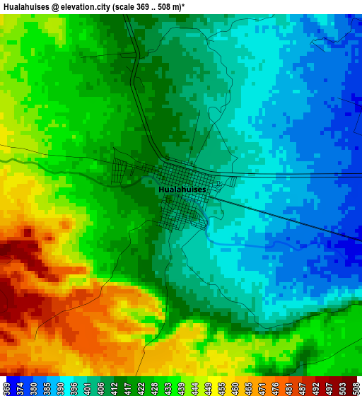
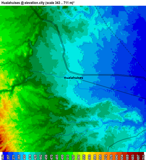
Below is the Elevation map of Hualahuises, which displays elevation range with different colors. Scale of the first map is from 369 to 508 m (1211 to 1667 ft) with average elevation of 419.8 meters (=1377 ft) [note 1]
These maps also provides idea of topography and contour of this city, they are displayed at different zoom levels. More info about maps, scale and edge coordinates you can find below images.
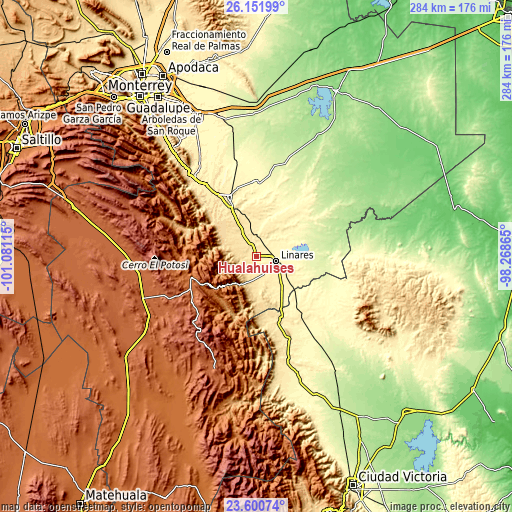
| \ | Map #1 | Map #2 | Topo.Map |
| Scale [m] | 369..508 m | 343..711 m | × |
| Scale [ft] | 1211..1667 ft | 1125..2333 ft | × |
| Average | 419.8 m = 1377 ft | 435.6 m = 1429 ft | × |
| Width | 8.87 km = 5.5 mi | 17.73 km = 11 mi | 283.7 km = 176.3 mi |
| Height | 8.87 km = 5.5 mi | 17.73 km = 11 mi | 283.7 km = 176.3 mi |
| ↑Max Latitude | 24.922809° | 24.962656° | 26.15199° |
| Latitude at center | 24.88295° | 24.88295° | 24.88295° |
| ↓Min Latitude | 24.843078° | 24.803193° | 23.60074° |
| ← Min Longitude | -99.718845° | -99.762791° | -101.08115° |
| Longitude center | -99.6749° | -99.6749° | -99.6749° |
| →Max Longitude | -99.630955° | -99.587009° | -98.26865° |
Nearby cities:
Cities around Hualahuises sort by population:
• Linares elevation 357 m
11.2 km,  104°
104°
• Mazatlan 422 m
37.4 km,  335°
335°
• Ciudad de Allende 447 m
55.6 km,  322°
322°
• Galeana 1631 m
41 km,  260°
260°
• Ciudad General Terán 316 m
41.8 km,  358°
358°
• Iturbide 1457 m
29 km,  232°
232°
• Guadalupe 300 m
20.6 km,  86°
86°
• Villagrán 385 m
49.3 km,  157°
157°
• Congregación Calles 453 m
46.2 km,  325°
325°
• Río Verde 330 m
13.4 km,  81°
81°
• Villa Mainero 482 m
36.4 km,  170°
170°
• Rayones 853 m
42.9 km,  290°
290°
Multilingual:
 En español:
Hualahuises elevación 407 m.
 En France:
Hualahuises élévation 407 m.
 Auf Deutsch:
Hualahuises höhe über dem Meeresspiegel ist 407 m.

Sources and notes:
- [note 1] Map square and city borders are not equal. Map elevation data is calculated only from area inside that square.
- [src 1] Elevation data from geonames database provided with same terms of usage.
- [src 2] The elevation map of Hualahuises is generated using elevation data from NASA's 3 arcsec (90m) resolution SRTM data.
- [src 3] Base (background) map © OpenStreetMap contributors tiles are generated by Geofabrik and OpenTopoMap.
Copyright & License:
This Hualahuises Elevation Map is licensed under CC BY-SA. You may reuse any part from this page, if you give a proper credit by linking to this URL:
 More info on terms of use page.