Ciudad General Terán elevation
Ciudad General Terán (Nuevo León, General Terán), Mexico elevation is 316 meters and Ciudad General Terán elevation in feet is 1037 ft above sea level [src 1]. Ciudad General Terán is a seat of a second-order administrative division (feature code) with elevation that is 998 meters (3274 ft) smaller than average city elevation in Mexico.
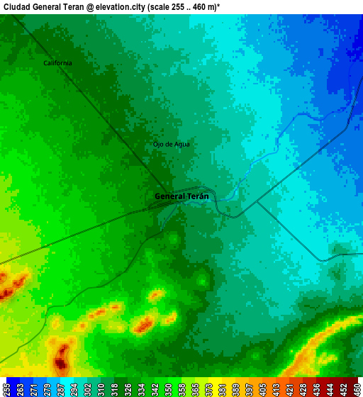
Below is the Elevation map of Ciudad General Terán, which displays elevation range with different colors. Scale of the first map is from 285 to 352 m (935 to 1155 ft) with average elevation of 316.4 meters (=1038 ft) [note 1]
These maps also provides idea of topography and contour of this city, they are displayed at different zoom levels. More info about maps, scale and edge coordinates you can find below images.

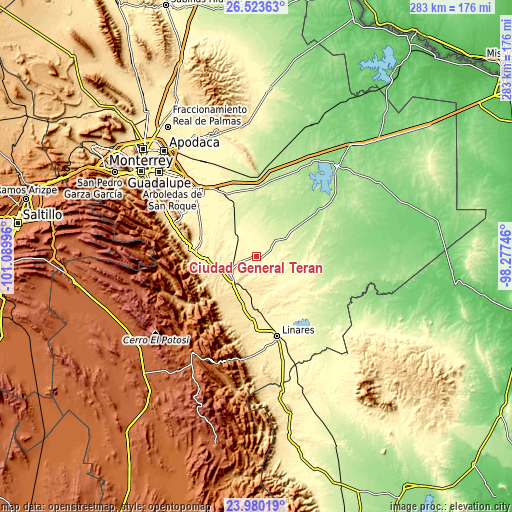
| \ | Map #1 | Map #2 | Topo.Map |
| Scale [m] | 285..352 m | 255..460 m | × |
| Scale [ft] | 935..1155 ft | 837..1509 ft | × |
| Average | 316.4 m = 1038 ft | 319.2 m = 1047 ft | × |
| Width | 8.84 km = 5.5 mi | 17.68 km = 11 mi | 282.8 km = 175.7 mi |
| Height | 8.84 km = 5.5 mi | 17.68 km = 11 mi | 282.8 km = 175.7 mi |
| ↑Max Latitude | 25.298307° | 25.338031° | 26.52363° |
| Latitude at center | 25.25857° | 25.25857° | 25.25857° |
| ↓Min Latitude | 25.21882° | 25.179056° | 23.98019° |
| ← Min Longitude | -99.727655° | -99.771601° | -101.08996° |
| Longitude center | -99.68371° | -99.68371° | -99.68371° |
| →Max Longitude | -99.639765° | -99.595819° | -98.27746° |
Nearby cities:
Cities around Ciudad General Terán sort by population:
• Cadereyta Jiménez elevation 330 m
48.7 km,  319°
319°
• Cadereyta 321 m
47 km, 320°
• Linares 357 m
46 km,  165°
165°
• Mazatlan 422 m
16.5 km,  242°
242°
• Ciudad de Allende 447 m
33.3 km,  273°
273°
• Hualahuises 407 m
41.8 km,  178°
178°
• San Juan 273 m
35.3 km,  333°
333°
• Guadalupe 300 m
45.8 km,  152°
152°
• Pueblo Nuevo 250 m
26.2 km,  343°
343°
• Congregación Calles 453 m
25.5 km,  261°
261°
• Río Verde 330 m
42.2 km,  160°
160°
• Rayones 853 m
47.5 km, 235°
Multilingual:
 En español:
General Teran, Ciudad General Terán elevación 316 m.
 En France:
Ciudad General Terán élévation 316 m.
 Auf Deutsch:
Ciudad General Terán höhe über dem Meeresspiegel ist 316 m.
 На русском:
Ciudad General Terán высота над уровнем моря 316 м
Sources and notes:
- [note 1] Map square and city borders are not equal. Map elevation data is calculated only from area inside that square.
- [src 1] Elevation data from geonames database provided with same terms of usage.
- [src 2] The elevation map of Ciudad General Terán is generated using elevation data from NASA's 3 arcsec (90m) resolution SRTM data.
- [src 3] Base (background) map © OpenStreetMap contributors tiles are generated by Geofabrik and OpenTopoMap.
Copyright & License:
This Ciudad General Terán Elevation Map is licensed under CC BY-SA. You may reuse any part from this page, if you give a proper credit by linking to this URL:
 More info on terms of use page.