San José de Raíces elevation
San José de Raíces (Nuevo León, Galeana), Mexico elevation is 1872 meters and San José de Raíces elevation in feet is 6142 ft above sea level [src 1]. San José de Raíces is a populated place (feature code) with elevation that is 558 meters (1831 ft) bigger than average city elevation in Mexico.
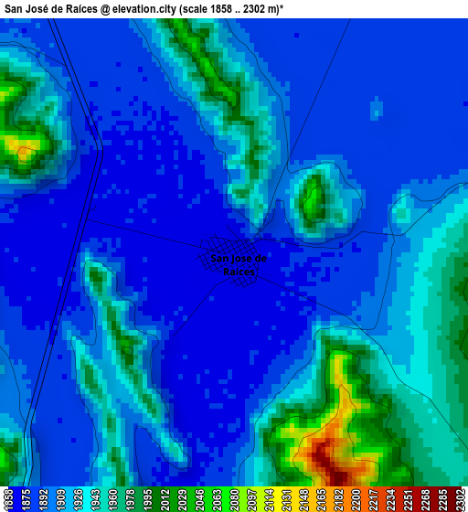
Below is the Elevation map of San José de Raíces, which displays elevation range with different colors. Scale of the first map is from 1858 to 2302 m (6096 to 7552 ft) with average elevation of 1915.2 meters (=6283 ft) [note 1]
These maps also provides idea of topography and contour of this city, they are displayed at different zoom levels. More info about maps, scale and edge coordinates you can find below images.
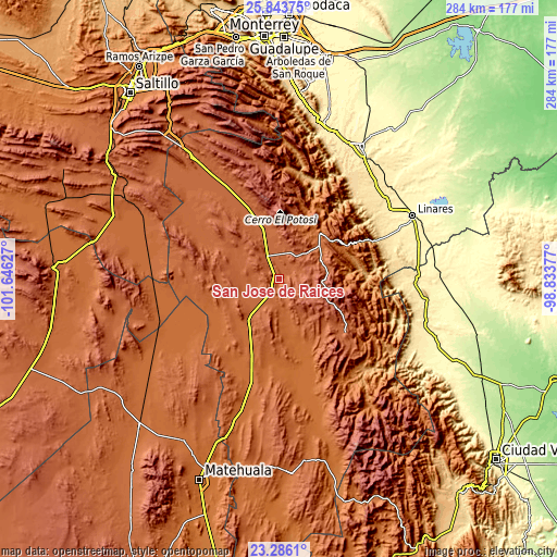
| \ | Map #1 | Topo.Map |
| Scale [m] | 1858..2302 m | × |
| Scale [ft] | 6096..7552 ft | × |
| Average | 1915.2 m = 6283 ft | × |
| Width | 8.89 km = 5.5 mi | 284.4 km = 176.7 mi |
| Height | 8.89 km = 5.5 mi | 284.4 km = 176.7 mi |
| ↑Max Latitude | 24.611409° | 25.84375° |
| Latitude at center | 24.57145° | 24.57145° |
| ↓Min Latitude | 24.531478° | 23.2861° |
| ← Min Longitude | -100.283965° | -101.64627° |
| Longitude center | -100.24002° | -100.24002° |
| →Max Longitude | -100.196075° | -98.83377° |
Nearby cities:
Cities around San José de Raíces sort by population:
• Linares elevation 357 m
75 km,  64°
64°
• Galeana 1631 m
32.7 km,  30°
30°
• Hualahuises 407 m
66.8 km, 58°
• La Ascensión 1961 m
43 km,  129°
129°
• Aramberri 1086 m
67.7 km,  140°
140°
• San Rafael 1886 m
60 km,  328°
328°
• Catarino Rodríguez 1891 m
31.5 km,  345°
345°
• Iturbide 1457 m
38.1 km, 63°
• Villagrán 385 m
76.6 km,  98°
98°
• El Salvador 1718 m
63.6 km,  264°
264°
• Villa Mainero 482 m
63.2 km,  91°
91°
• Rayones 853 m
52.4 km,  18°
18°
Multilingual:
 En español:
San José de Raíces elevación 1872 m.
 En France:
San José de Raíces élévation 1872 m.
 Auf Deutsch:
San José de Raíces höhe über dem Meeresspiegel ist 1872 m.
 На русском:
San José de Raíces высота над уровнем моря 1872 м
Sources and notes:
- [note 1] Map square and city borders are not equal. Map elevation data is calculated only from area inside that square.
- [src 1] Elevation data from geonames database provided with same terms of usage.
- [src 2] The elevation map of San José de Raíces is generated using elevation data from NASA's 3 arcsec (90m) resolution SRTM data.
- [src 3] Base (background) map © OpenStreetMap contributors tiles are generated by Geofabrik and OpenTopoMap.
Copyright & License:
This San José de Raíces Elevation Map is licensed under CC BY-SA. You may reuse any part from this page, if you give a proper credit by linking to this URL:
 More info on terms of use page.