Santiago elevation
Santiago (Nuevo León), Mexico elevation is 490 meters and Santiago elevation in feet is 1608 ft above sea level [src 1]. Santiago is a seat of a second-order administrative division (feature code) with elevation that is 824 meters (2703 ft) smaller than average city elevation in Mexico.
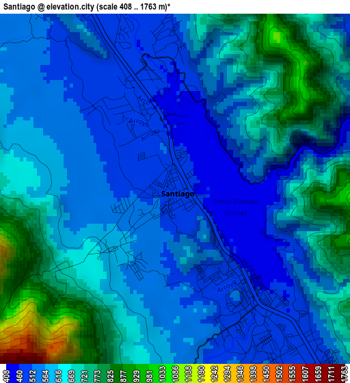
Below is the Elevation map of Santiago, which displays elevation range with different colors. Scale of the first map is from 408 to 1763 m (1339 to 5784 ft) with average elevation of 609.9 meters (=2001 ft) [note 1]
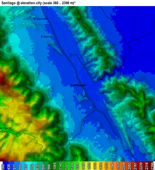
These maps also provides idea of topography and contour of this city, they are displayed at different zoom levels. More info about maps, scale and edge coordinates you can find below images.
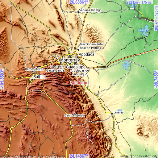
| \ | Map #1 | Map #2 | Topo.Map |
| Scale [m] | 408..1763 m | 360..2396 m | × |
| Scale [ft] | 1339..5784 ft | 1181..7861 ft | × |
| Average | 609.9 m = 2001 ft | 779.7 m = 2558 ft | × |
| Width | 8.83 km = 5.5 mi | 17.65 km = 11 mi | 282.4 km = 175.5 mi |
| Height | 8.83 km = 5.5 mi | 17.65 km = 11 mi | 282.4 km = 175.5 mi |
| ↑Max Latitude | 25.465012° | 25.504682° | 26.68861° |
| Latitude at center | 25.42533° | 25.42533° | 25.42533° |
| ↓Min Latitude | 25.385634° | 25.345926° | 24.14867° |
| ← Min Longitude | -100.195995° | -100.239941° | -101.5583° |
| Longitude center | -100.15205° | -100.15205° | -100.15205° |
| →Max Longitude | -100.108105° | -100.064159° | -98.7458° |
Nearby cities:
Cities around Santiago sort by population:
• Guadalupe elevation 497 m
29.9 km,  339°
339°
• Ciudad Benito Juárez 388 m
25.3 km,  12°
12°
• Cadereyta Jiménez 330 m
23.6 km,  39°
39°
• Cadereyta 321 m
24.4 km, 43°
• Jardines de la Silla (Jardines) 512 m
23 km,  351°
351°
• Ciudad de Allende 447 m
21.5 km,  140°
140°
• Héctor Caballero 429 m
23.5 km, 6°
• Monte Kristal 457 m
22.3 km,  358°
358°
• Valle de Vaquerías 444 m
23 km,  1°
1°
• San Antonio 374 m
25.5 km,  21°
21°
• Bosques de San Pedro 525 m
19.8 km, 351°
• Valle de Juárez 455 m
23.6 km, 358°
Multilingual:
 En español:
Santiago, Villa de Santiago elevación 490 m.
 En France:
Santiago élévation 490 m.
 Auf Deutsch:
Santiago höhe über dem Meeresspiegel ist 490 m.

Sources and notes:
- [note 1] Map square and city borders are not equal. Map elevation data is calculated only from area inside that square.
- [src 1] Elevation data from geonames database provided with same terms of usage.
- [src 2] The elevation map of Santiago is generated using elevation data from NASA's 3 arcsec (90m) resolution SRTM data.
- [src 3] Base (background) map © OpenStreetMap contributors tiles are generated by Geofabrik and OpenTopoMap.
Copyright & License:
This Santiago Elevation Map is licensed under CC BY-SA. You may reuse any part from this page, if you give a proper credit by linking to this URL:
 More info on terms of use page.