San Miguel Tlacotepec elevation
San Miguel Tlacotepec (Oaxaca), Mexico elevation is 1734 meters and San Miguel Tlacotepec elevation in feet is 5689 ft above sea level [src 1]. San Miguel Tlacotepec is a populated place (feature code) with elevation that is 420 meters (1378 ft) bigger than average city elevation in Mexico.
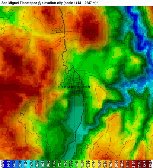
Below is the Elevation map of San Miguel Tlacotepec, which displays elevation range with different colors. Scale of the first map is from 1414 to 2247 m (4639 to 7372 ft) with average elevation of 1883.2 meters (=6178 ft) [note 1]
These maps also provides idea of topography and contour of this city, they are displayed at different zoom levels. More info about maps, scale and edge coordinates you can find below images.
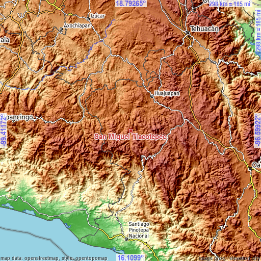
| \ | Map #1 | Topo.Map |
| Scale [m] | 1414..2247 m | × |
| Scale [ft] | 4639..7372 ft | × |
| Average | 1883.2 m = 6178 ft | × |
| Width | 9.32 km = 5.8 mi | 298.3 km = 185.4 mi |
| Height | 9.32 km = 5.8 mi | 298.3 km = 185.4 mi |
| ↑Max Latitude | 17.498127° | 18.79265° |
| Latitude at center | 17.45621° | 17.45621° |
| ↓Min Latitude | 17.414284° | 16.1099° |
| ← Min Longitude | -98.049415° | -99.41172° |
| Longitude center | -98.00547° | -98.00547° |
| →Max Longitude | -97.961525° | -96.59922° |
Nearby cities:
Cities around San Miguel Tlacotepec sort by population:
• Santiago Juxtlahuaca elevation 1693 m
13.5 km,  182°
182°
• Santo Domingo Tonalá 1375 m
24.5 km,  9°
9°
• San Sebastián Tecomaxtlahuaca 1706 m
12.4 km,  192°
192°
• Silacayoápam 1644 m
15.2 km,  290°
290°
• San Miguel Monteverde 2176 m
24.1 km,  69°
69°
• San Jorge Nuchita 1196 m
24.6 km,  334°
334°
• San Agustín Atenango 1298 m
17.3 km,  358°
358°
• Yetla de Juárez 1314 m
23.3 km,  3°
3°
• Santos Reyes Tepejillo 1952 m
7.4 km,  106°
106°
• Santa Rosa Caxtlahuaca 1729 m
17.1 km, 184°
• Peña Colorada 2369 m
22.5 km,  83°
83°
• Ixpantepec Nieves 2060 m
6.9 km, 325°
Multilingual:
 En español:
San Miguel Tlacotepec elevación 1734 m.
 En France:
San Miguel Tlacotepec élévation 1734 m.
 Auf Deutsch:
San Miguel Tlacotepec höhe über dem Meeresspiegel ist 1734 m.
 На русском:
San Miguel Tlacotepec высота над уровнем моря 1734 м
Sources and notes:
- [note 1] Map square and city borders are not equal. Map elevation data is calculated only from area inside that square.
- [src 1] Elevation data from geonames database provided with same terms of usage.
- [src 2] The elevation map of San Miguel Tlacotepec is generated using elevation data from NASA's 3 arcsec (90m) resolution SRTM data.
- [src 3] Base (background) map © OpenStreetMap contributors tiles are generated by Geofabrik and OpenTopoMap.
Copyright & License:
This San Miguel Tlacotepec Elevation Map is licensed under CC BY-SA. You may reuse any part from this page, if you give a proper credit by linking to this URL:
 More info on terms of use page.