Santo Domingo Tonalá elevation
Santo Domingo Tonalá (Oaxaca), Mexico elevation is 1375 meters and Santo Domingo Tonalá elevation in feet is 4511 ft above sea level [src 1]. Santo Domingo Tonalá is a seat of a second-order administrative division (feature code) with elevation that is 61 meters (200 ft) bigger than average city elevation in Mexico.
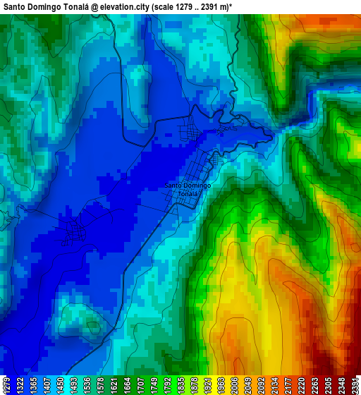
Below is the Elevation map of Santo Domingo Tonalá, which displays elevation range with different colors. Scale of the first map is from 1279 to 2391 m (4196 to 7844 ft) with average elevation of 1578.8 meters (=5180 ft) [note 1]
These maps also provides idea of topography and contour of this city, they are displayed at different zoom levels. More info about maps, scale and edge coordinates you can find below images.
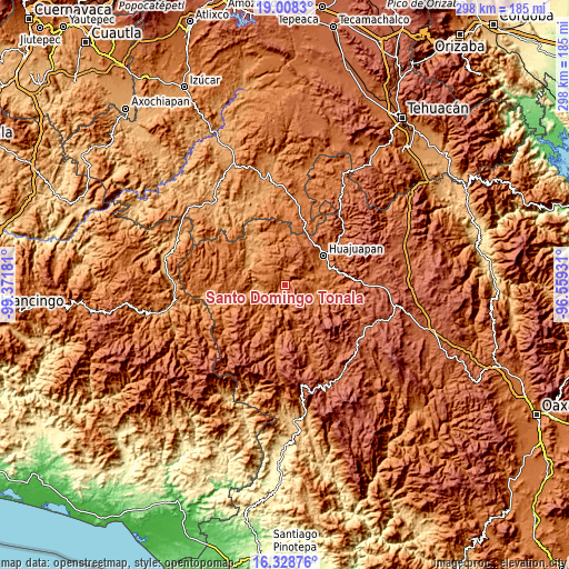
| \ | Map #1 | Topo.Map |
| Scale [m] | 1279..2391 m | × |
| Scale [ft] | 4196..7844 ft | × |
| Average | 1578.8 m = 5180 ft | × |
| Width | 9.31 km = 5.8 mi | 297.9 km = 185.1 mi |
| Height | 9.31 km = 5.8 mi | 298 km = 185.2 mi |
| ↑Max Latitude | 17.715386° | 19.0083° |
| Latitude at center | 17.67352° | 17.67352° |
| ↓Min Latitude | 17.631644° | 16.32876° |
| ← Min Longitude | -98.009505° | -99.37181° |
| Longitude center | -97.96556° | -97.96556° |
| →Max Longitude | -97.921615° | -96.55931° |
Nearby cities:
Cities around Santo Domingo Tonalá sort by population:
• San Miguel Monteverde elevation 2176 m
24.2 km,  130°
130°
• San Jorge Nuchita 1196 m
14.8 km,  262°
262°
• San Miguel Tlacotepec 1734 m
24.5 km,  189°
189°
• San Sebastián del Monte 1655 m
6 km,  274°
274°
• San Agustín Atenango 1298 m
8.4 km,  214°
214°
• Yetla de Juárez 1314 m
2.9 km,  252°
252°
• San Marcos Arteaga 1482 m
12.4 km,  64°
64°
• Santiago Cacaloxtepec 1715 m
24.4 km,  77°
77°
• San Jerónimo Silacayoapilla 1706 m
19.9 km,  40°
40°
• Ixpantepec Nieves 2060 m
20.2 km,  203°
203°
• San Lorenzo 1188 m
16.4 km, 268°
• Tezoatlán de Segura y Luna 1522 m
16.6 km,  97°
97°
Multilingual:
 En español:
Santo Domingo Tonalá elevación 1375 m.
 En France:
Santo Domingo Tonalá élévation 1375 m.
 Auf Deutsch:
Santo Domingo Tonalá höhe über dem Meeresspiegel ist 1375 m.
 На русском:
Santo Domingo Tonalá высота над уровнем моря 1375 м
Sources and notes:
- [note 1] Map square and city borders are not equal. Map elevation data is calculated only from area inside that square.
- [src 1] Elevation data from geonames database provided with same terms of usage.
- [src 2] The elevation map of Santo Domingo Tonalá is generated using elevation data from NASA's 3 arcsec (90m) resolution SRTM data.
- [src 3] Base (background) map © OpenStreetMap contributors tiles are generated by Geofabrik and OpenTopoMap.
Copyright & License:
This Santo Domingo Tonalá Elevation Map is licensed under CC BY-SA. You may reuse any part from this page, if you give a proper credit by linking to this URL:
 More info on terms of use page.