San Miguel Monteverde elevation
San Miguel Monteverde (Oaxaca, San Antonino Monte Verde), Mexico elevation is 2176 meters and San Miguel Monteverde elevation in feet is 7139 ft above sea level [src 1]. San Miguel Monteverde is a populated place (feature code) with elevation that is 862 meters (2828 ft) bigger than average city elevation in Mexico.
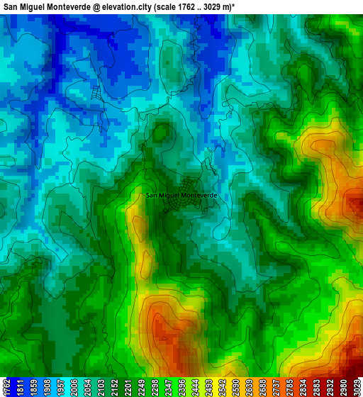
Below is the Elevation map of San Miguel Monteverde, which displays elevation range with different colors. Scale of the first map is from 1762 to 3029 m (5781 to 9938 ft) with average elevation of 2167.2 meters (=7110 ft) [note 1]
These maps also provides idea of topography and contour of this city, they are displayed at different zoom levels. More info about maps, scale and edge coordinates you can find below images.
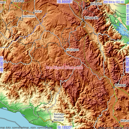
| \ | Map #1 | Topo.Map |
| Scale [m] | 1762..3029 m | × |
| Scale [ft] | 5781..9938 ft | × |
| Average | 2167.2 m = 7110 ft | × |
| Width | 9.32 km = 5.8 mi | 298.2 km = 185.3 mi |
| Height | 9.32 km = 5.8 mi | 298.2 km = 185.3 mi |
| ↑Max Latitude | 17.573009° | 18.86698° |
| Latitude at center | 17.53111° | 17.53111° |
| ↓Min Latitude | 17.489201° | 16.18533° |
| ← Min Longitude | -97.836445° | -99.19875° |
| Longitude center | -97.7925° | -97.7925° |
| →Max Longitude | -97.748555° | -96.38625° |
Nearby cities:
Cities around San Miguel Monteverde sort by population:
• Santa María Chilapa de Díaz elevation 2416 m
11.7 km,  97°
97°
• San Miguel Tlacotepec 1734 m
24.1 km,  249°
249°
• San Sebastián Nicananduta 2401 m
11.6 km, 97°
• Santos Reyes Tepejillo 1952 m
18.6 km,  236°
236°
• San Marcos Arteaga 1482 m
22.4 km,  341°
341°
• San Andrés Dinicuiti 1686 m
18.8 km,  21°
21°
• Peña Colorada 2369 m
5.9 km,  181°
181°
• Santiago Cacaloxtepec 1715 m
21.9 km,  14°
14°
• Santo Domingo Yodohino 1654 m
15 km,  50°
50°
• San Pedro Mártir Yucuxaco 2249 m
22.2 km,  119°
119°
• San Juan Ñumí 2209 m
17.5 km,  148°
148°
• Tezoatlán de Segura y Luna 1522 m
13.8 km,  351°
351°
Multilingual:
 En español:
San Miguel Monteverde elevación 2176 m.
 En France:
San Miguel Monteverde élévation 2176 m.
 Auf Deutsch:
San Miguel Monteverde höhe über dem Meeresspiegel ist 2176 m.
 На русском:
San Miguel Monteverde высота над уровнем моря 2176 м
Sources and notes:
- [note 1] Map square and city borders are not equal. Map elevation data is calculated only from area inside that square.
- [src 1] Elevation data from geonames database provided with same terms of usage.
- [src 2] The elevation map of San Miguel Monteverde is generated using elevation data from NASA's 3 arcsec (90m) resolution SRTM data.
- [src 3] Base (background) map © OpenStreetMap contributors tiles are generated by Geofabrik and OpenTopoMap.
Copyright & License:
This San Miguel Monteverde Elevation Map is licensed under CC BY-SA. You may reuse any part from this page, if you give a proper credit by linking to this URL:
 More info on terms of use page.