Silacayoápam elevation
Silacayoápam (Oaxaca), Mexico elevation is 1644 meters and Silacayoápam elevation in feet is 5394 ft above sea level [src 1]. Silacayoápam is a seat of a second-order administrative division (feature code) with elevation that is 330 meters (1083 ft) bigger than average city elevation in Mexico.
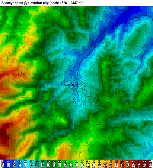
Below is the Elevation map of Silacayoápam, which displays elevation range with different colors. Scale of the first map is from 1526 to 2447 m (5007 to 8028 ft) with average elevation of 1850.2 meters (=6070 ft) [note 1]
These maps also provides idea of topography and contour of this city, they are displayed at different zoom levels. More info about maps, scale and edge coordinates you can find below images.
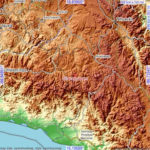
| \ | Map #1 | Topo.Map |
| Scale [m] | 1526..2447 m | × |
| Scale [ft] | 5007..8028 ft | × |
| Average | 1850.2 m = 6070 ft | × |
| Width | 9.32 km = 5.8 mi | 298.2 km = 185.3 mi |
| Height | 9.32 km = 5.8 mi | 298.2 km = 185.3 mi |
| ↑Max Latitude | 17.544876° | 18.83905° |
| Latitude at center | 17.50297° | 17.50297° |
| ↓Min Latitude | 17.461054° | 16.15699° |
| ← Min Longitude | -98.183605° | -99.54591° |
| Longitude center | -98.13966° | -98.13966° |
| →Max Longitude | -98.095715° | -96.73341° |
Nearby cities:
Cities around Silacayoápam sort by population:
• San Martín Peras elevation 2230 m
19 km,  212°
212°
• San Sebastián Tecomaxtlahuaca 1706 m
20.8 km,  146°
146°
• Tamazola 1784 m
20.5 km,  335°
335°
• San Jorge Nuchita 1196 m
17.5 km,  12°
12°
• San Miguel Tlacotepec 1734 m
15.2 km,  110°
110°
• San Agustín Atenango 1298 m
18.2 km,  48°
48°
• Ahuajutla 1677 m
17.9 km,  243°
243°
• Ixpantepec Nieves 2060 m
10.3 km,  87°
87°
• Calihualá 1327 m
15 km,  282°
282°
• San Lorenzo 1188 m
18.5 km, 6°
• Santa Cruz de Bravo 1644 m
12.4 km,  314°
314°
• Yucuyachi 1449 m
13.2 km,  332°
332°
Multilingual:
 En español:
Silacayoapan, Villa Silacayoapan, Silacayoápam elevación 1644 m.
 En France:
Silacayoápam élévation 1644 m.
 Auf Deutsch:
Silacayoápam höhe über dem Meeresspiegel ist 1644 m.

Sources and notes:
- [note 1] Map square and city borders are not equal. Map elevation data is calculated only from area inside that square.
- [src 1] Elevation data from geonames database provided with same terms of usage.
- [src 2] The elevation map of Silacayoápam is generated using elevation data from NASA's 3 arcsec (90m) resolution SRTM data.
- [src 3] Base (background) map © OpenStreetMap contributors tiles are generated by Geofabrik and OpenTopoMap.
Copyright & License:
This Silacayoápam Elevation Map is licensed under CC BY-SA. You may reuse any part from this page, if you give a proper credit by linking to this URL:
 More info on terms of use page.