Ahuajutla elevation
Ahuajutla (Guerrero), Mexico elevation is 1677 meters and Ahuajutla elevation in feet is 5502 ft above sea level [src 1]. Ahuajutla is a populated place (feature code) with elevation that is 363 meters (1191 ft) bigger than average city elevation in Mexico.
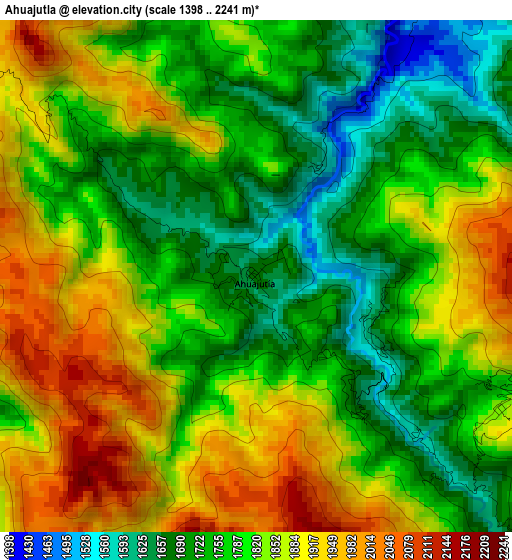
Below is the Elevation map of Ahuajutla, which displays elevation range with different colors. Scale of the first map is from 1398 to 2241 m (4587 to 7352 ft) with average elevation of 1808.4 meters (=5933 ft) [note 1]
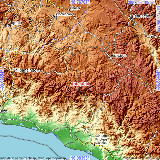
These maps also provides idea of topography and contour of this city, they are displayed at different zoom levels. More info about maps, scale and edge coordinates you can find below images.
| \ | Map #1 | Topo.Map |
| Scale [m] | 1398..2241 m | × |
| Scale [ft] | 4587..7352 ft | × |
| Average | 1808.4 m = 5933 ft | × |
| Width | 9.32 km = 5.8 mi | 298.3 km = 185.4 mi |
| Height | 9.32 km = 5.8 mi | 298.4 km = 185.4 mi |
| ↑Max Latitude | 17.472353° | 18.76707° |
| Latitude at center | 17.43043° | 17.43043° |
| ↓Min Latitude | 17.388498° | 16.08393° |
| ← Min Longitude | -98.334235° | -99.69654° |
| Longitude center | -98.29029° | -98.29029° |
| →Max Longitude | -98.246345° | -96.88404° |
Nearby cities:
Cities around Ahuajutla sort by population:
• San Martín Peras elevation 2230 m
9.7 km,  144°
144°
• Alcozauca de Guerrero 1333 m
10.7 km,  290°
290°
• Tlalixtaquilla 1150 m
18.2 km,  333°
333°
• Silacayoápam 1644 m
17.9 km,  63°
63°
• San Vicente Zoyatlán 2059 m
14.3 km,  213°
213°
• Xochapa 1440 m
17.8 km,  253°
253°
• Cuyuxtlahuaca 1694 m
8.1 km,  314°
314°
• Santa Cruz 1660 m
16.5 km, 313°
• Tlahuapa 1614 m
7.9 km,  219°
219°
• La Luz de Juárez 1400 m
13.2 km, 332°
• Calihualá 1327 m
11.3 km,  6°
6°
• Santa Cruz de Bravo 1644 m
18.2 km,  22°
22°
Multilingual:
 En español:
Ahuajutla elevación 1677 m.
 En France:
Ahuajutla élévation 1677 m.
 Auf Deutsch:
Ahuajutla höhe über dem Meeresspiegel ist 1677 m.

Sources and notes:
- [note 1] Map square and city borders are not equal. Map elevation data is calculated only from area inside that square.
- [src 1] Elevation data from geonames database provided with same terms of usage.
- [src 2] The elevation map of Ahuajutla is generated using elevation data from NASA's 3 arcsec (90m) resolution SRTM data.
- [src 3] Base (background) map © OpenStreetMap contributors tiles are generated by Geofabrik and OpenTopoMap.
Copyright & License:
This Ahuajutla Elevation Map is licensed under CC BY-SA. You may reuse any part from this page, if you give a proper credit by linking to this URL:
 More info on terms of use page.