Xochapa elevation
Xochapa (Guerrero, Alcozauca de Guerrero), Mexico elevation is 1440 meters and Xochapa elevation in feet is 4724 ft above sea level [src 1]. Xochapa is a populated place (feature code) with elevation that is 126 meters (413 ft) bigger than average city elevation in Mexico.
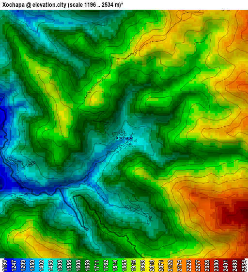
Below is the Elevation map of Xochapa, which displays elevation range with different colors. Scale of the first map is from 1196 to 2534 m (3924 to 8314 ft) with average elevation of 1749.1 meters (=5739 ft) [note 1]
These maps also provides idea of topography and contour of this city, they are displayed at different zoom levels. More info about maps, scale and edge coordinates you can find below images.
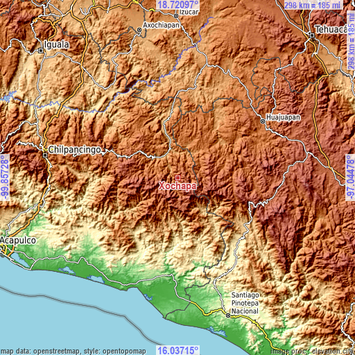
| \ | Map #1 | Topo.Map |
| Scale [m] | 1196..2534 m | × |
| Scale [ft] | 3924..8314 ft | × |
| Average | 1749.1 m = 5739 ft | × |
| Width | 9.33 km = 5.8 mi | 298.4 km = 185.4 mi |
| Height | 9.33 km = 5.8 mi | 298.4 km = 185.4 mi |
| ↑Max Latitude | 17.425913° | 18.72097° |
| Latitude at center | 17.38398° | 17.38398° |
| ↓Min Latitude | 17.342037° | 16.03715° |
| ← Min Longitude | -98.494975° | -99.85728° |
| Longitude center | -98.45103° | -98.45103° |
| →Max Longitude | -98.407085° | -97.04478° |
Nearby cities:
Cities around Xochapa sort by population:
• Tototepec elevation 1677 m
15.4 km,  290°
290°
• Alcozauca de Guerrero 1333 m
11.4 km,  38°
38°
• Xalatzala 1703 m
16.4 km,  307°
307°
• San Vicente Zoyatlán 2059 m
11.5 km,  126°
126°
• Cuyuxtlahuaca 1694 m
15.7 km,  45°
45°
• Cahuatache 1556 m
9.3 km, 292°
• Santa Cruz 1660 m
17.4 km,  17°
17°
• Tlahuapa 1614 m
12.1 km,  94°
94°
• San Rafael 2182 m
17.7 km,  170°
170°
• San Pablo Atzompa 2181 m
17.5 km,  150°
150°
• Zilacayotitlán 2255 m
14.4 km,  226°
226°
• Melchor Ocampo 1535 m
2.8 km, 172°
Multilingual:
 En español:
Xochapa elevación 1440 m.
 En France:
Xochapa élévation 1440 m.
 Auf Deutsch:
Xochapa höhe über dem Meeresspiegel ist 1440 m.

Sources and notes:
- [note 1] Map square and city borders are not equal. Map elevation data is calculated only from area inside that square.
- [src 1] Elevation data from geonames database provided with same terms of usage.
- [src 2] The elevation map of Xochapa is generated using elevation data from NASA's 3 arcsec (90m) resolution SRTM data.
- [src 3] Base (background) map © OpenStreetMap contributors tiles are generated by Geofabrik and OpenTopoMap.
Copyright & License:
This Xochapa Elevation Map is licensed under CC BY-SA. You may reuse any part from this page, if you give a proper credit by linking to this URL:
 More info on terms of use page.