San Sebastián Tecomaxtlahuaca elevation
San Sebastián Tecomaxtlahuaca (Oaxaca), Mexico elevation is 1706 meters and San Sebastián Tecomaxtlahuaca elevation in feet is 5597 ft above sea level [src 1]. San Sebastián Tecomaxtlahuaca is a populated place (feature code) with elevation that is 392 meters (1286 ft) bigger than average city elevation in Mexico.
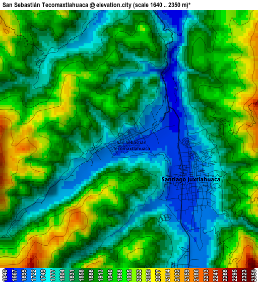
Below is the Elevation map of San Sebastián Tecomaxtlahuaca, which displays elevation range with different colors. Scale of the first map is from 1640 to 2350 m (5381 to 7710 ft) with average elevation of 1879.2 meters (=6165 ft) [note 1]
These maps also provides idea of topography and contour of this city, they are displayed at different zoom levels. More info about maps, scale and edge coordinates you can find below images.
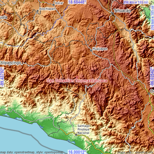
| \ | Map #1 | Topo.Map |
| Scale [m] | 1640..2350 m | × |
| Scale [ft] | 5381..7710 ft | × |
| Average | 1879.2 m = 6165 ft | × |
| Width | 9.33 km = 5.8 mi | 298.5 km = 185.5 mi |
| Height | 9.33 km = 5.8 mi | 298.5 km = 185.5 mi |
| ↑Max Latitude | 17.389152° | 18.68448° |
| Latitude at center | 17.34721° | 17.34721° |
| ↓Min Latitude | 17.305259° | 16.00012° |
| ← Min Longitude | -98.075615° | -99.43792° |
| Longitude center | -98.03167° | -98.03167° |
| →Max Longitude | -97.987725° | -96.62542° |
Nearby cities:
Cities around San Sebastián Tecomaxtlahuaca sort by population:
• Santiago Juxtlahuaca elevation 1693 m
2.6 km,  123°
123°
• San Martín Peras 2230 m
21.9 km,  273°
273°
• Silacayoápam 1644 m
20.8 km,  326°
326°
• San Miguel Tlacotepec 1734 m
12.4 km,  12°
12°
• Santa María Yucunicoco 2454 m
17.2 km,  135°
135°
• San Martín Itunyoso 2612 m
20.8 km,  129°
129°
• San Miguel el Grande 1737 m
24.4 km,  242°
242°
• Santos Reyes Tepejillo 1952 m
14.1 km,  44°
44°
• Santiago Tilapa 1918 m
26.3 km,  248°
248°
• Santa Rosa Caxtlahuaca 1729 m
5.2 km,  162°
162°
• Ixpantepec Nieves 2060 m
17.8 km,  356°
356°
• San Juan Mixtepec 1739 m
21.7 km,  102°
102°
Multilingual:
 En español:
San Sebastián Tecomaxtlahuaca elevación 1706 m.
 En France:
San Sebastián Tecomaxtlahuaca élévation 1706 m.
 Auf Deutsch:
San Sebastián Tecomaxtlahuaca höhe über dem Meeresspiegel ist 1706 m.
 На русском:
San Sebastián Tecomaxtlahuaca высота над уровнем моря 1706 м
Sources and notes:
- [note 1] Map square and city borders are not equal. Map elevation data is calculated only from area inside that square.
- [src 1] Elevation data from geonames database provided with same terms of usage.
- [src 2] The elevation map of San Sebastián Tecomaxtlahuaca is generated using elevation data from NASA's 3 arcsec (90m) resolution SRTM data.
- [src 3] Base (background) map © OpenStreetMap contributors tiles are generated by Geofabrik and OpenTopoMap.
Copyright & License:
This San Sebastián Tecomaxtlahuaca Elevation Map is licensed under CC BY-SA. You may reuse any part from this page, if you give a proper credit by linking to this URL:
 More info on terms of use page.