Soyaló elevation
Soyaló (Chiapas), Mexico elevation is 1172 meters and Soyaló elevation in feet is 3845 ft above sea level [src 1]. Soyaló is a seat of a second-order administrative division (feature code) with elevation that is 142 meters (466 ft) smaller than average city elevation in Mexico.
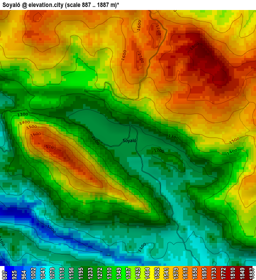
Below is the Elevation map of Soyaló, which displays elevation range with different colors. Scale of the first map is from 887 to 1887 m (2910 to 6191 ft) with average elevation of 1374.1 meters (=4508 ft) [note 1]
These maps also provides idea of topography and contour of this city, they are displayed at different zoom levels. More info about maps, scale and edge coordinates you can find below images.
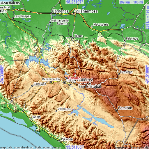
| \ | Map #1 | Map #2 | Topo.Map |
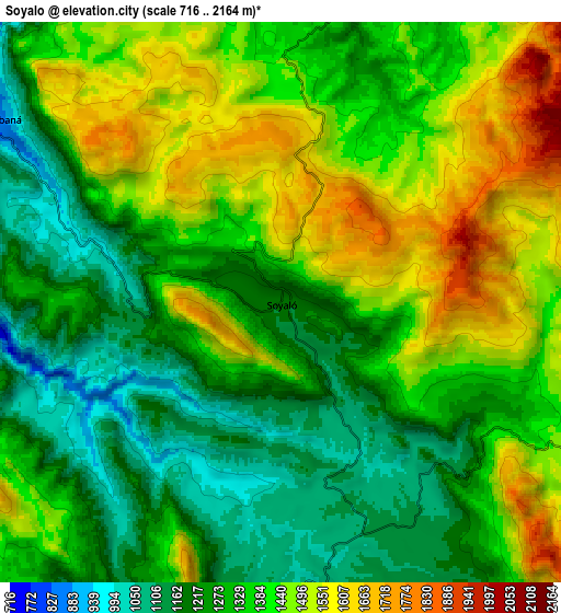
| Scale [m] | 887..1887 m | 716..2164 m | × |
| Scale [ft] | 2910..6191 ft | 2349..7100 ft | × |
| Average | 1374.1 m = 4508 ft | 1358.2 m = 4456 ft | × |
| Width | 9.35 km = 5.8 mi | 18.7 km = 11.6 mi | 299.2 km = 185.9 mi |
| Height | 9.35 km = 5.8 mi | 18.7 km = 11.6 mi | 299.2 km = 185.9 mi |
| ↑Max Latitude | 16.933345° | 16.97538° | 18.23197° |
| Latitude at center | 16.8913° | 16.8913° | 16.8913° |
| ↓Min Latitude | 16.849246° | 16.807182° | 15.54103° |
| ← Min Longitude | -92.968275° | -93.012221° | -94.33058° |
| Longitude center | -92.92433° | -92.92433° | -92.92433° |
| →Max Longitude | -92.880385° | -92.836439° | -91.51808° |
Nearby cities:
Cities around Soyaló sort by population:
• Bochil elevation 1162 m
12.2 km,  16°
16°
• Ixtapa 1116 m
10 km,  168°
168°
• Francisco Sarabia 865 m
11.2 km,  302°
302°
• El Nopal 1549 m
8.8 km,  75°
75°
• El Palmar (San Gabriel) 1348 m
11 km,  242°
242°
• Venustiano Carranza 1323 m
8.6 km,  273°
273°
• Ajilhó 1312 m
10.4 km,  351°
351°
• Cacaté 1476 m
10.8 km,  118°
118°
• Concepción 1284 m
10.1 km,  205°
205°
• El Copal 1392 m
8.5 km,  358°
358°
• El Zapotillo 1012 m
6.7 km, 205°
• Pugchén Mumuntic 1603 m
11.1 km,  105°
105°
Multilingual:
 En español:
Soyaló elevación 1172 m.
 En France:
Soyaló élévation 1172 m.


Sources and notes:
- [note 1] Map square and city borders are not equal. Map elevation data is calculated only from area inside that square.
- [src 1] Elevation data from geonames database provided with same terms of usage.
- [src 2] The elevation map of Soyaló is generated using elevation data from NASA's 3 arcsec (90m) resolution SRTM data.
- [src 3] Base (background) map © OpenStreetMap contributors tiles are generated by Geofabrik and OpenTopoMap.
Copyright & License:
This Soyaló Elevation Map is licensed under CC BY-SA. You may reuse any part from this page, if you give a proper credit by linking to this URL:
 More info on terms of use page.