Ixtapa elevation
Ixtapa (Chiapas), Mexico elevation is 1116 meters and Ixtapa elevation in feet is 3661 ft above sea level [src 1]. Ixtapa is a seat of a second-order administrative division (feature code) with elevation that is 198 meters (650 ft) smaller than average city elevation in Mexico.
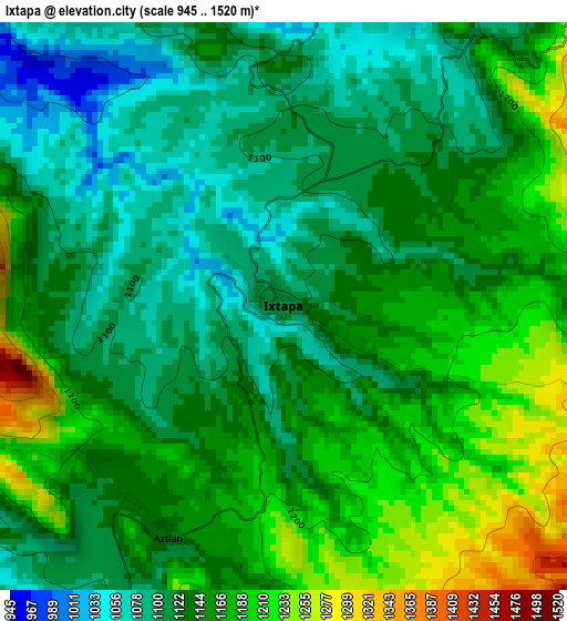
Below is the Elevation map of Ixtapa, which displays elevation range with different colors. Scale of the first map is from 945 to 1520 m (3100 to 4987 ft) with average elevation of 1143.3 meters (=3751 ft) [note 1]
These maps also provides idea of topography and contour of this city, they are displayed at different zoom levels. More info about maps, scale and edge coordinates you can find below images.
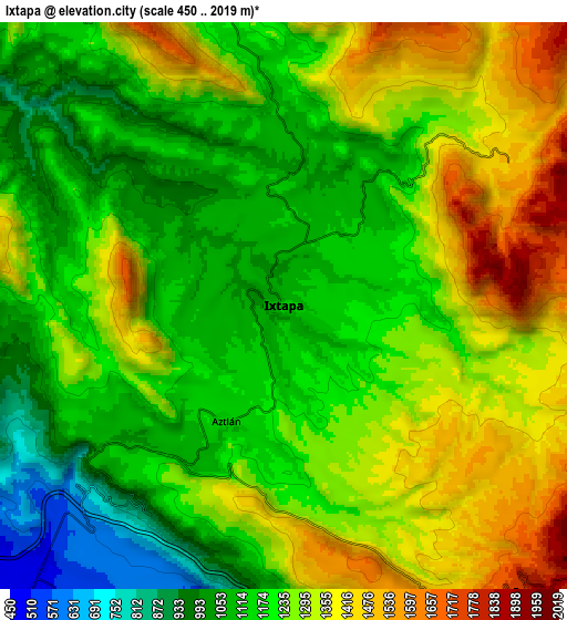
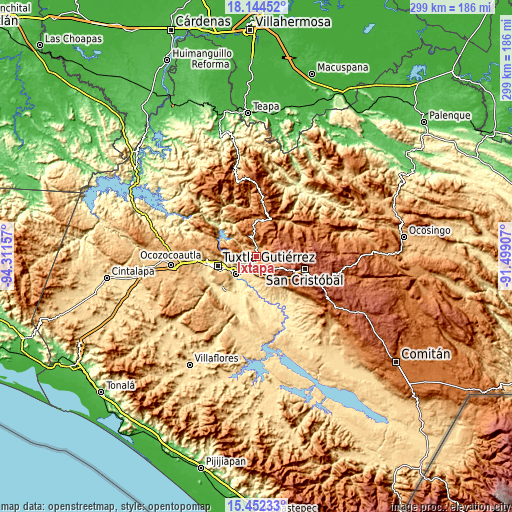
| \ | Map #1 | Map #2 | Topo.Map |
| Scale [m] | 945..1520 m | 450..2019 m | × |
| Scale [ft] | 3100..4987 ft | 1476..6624 ft | × |
| Average | 1143.3 m = 3751 ft | 1231.8 m = 4041 ft | × |
| Width | 9.36 km = 5.8 mi | 18.71 km = 11.6 mi | 299.3 km = 186 mi |
| Height | 9.36 km = 5.8 mi | 18.71 km = 11.6 mi | 299.4 km = 186 mi |
| ↑Max Latitude | 16.845264° | 16.887319° | 18.14452° |
| Latitude at center | 16.8032° | 16.8032° | 16.8032° |
| ↓Min Latitude | 16.761126° | 16.719043° | 15.45233° |
| ← Min Longitude | -92.949265° | -92.993211° | -94.31157° |
| Longitude center | -92.90532° | -92.90532° | -92.90532° |
| →Max Longitude | -92.861375° | -92.817429° | -91.49907° |
Nearby cities:
Cities around Ixtapa sort by population:
• Soyaló elevation 1172 m
10 km,  348°
348°
• El Nopal 1549 m
13.7 km,  28°
28°
• Yaltem 2302 m
13 km,  69°
69°
• El Palmar (San Gabriel) 1348 m
12.7 km,  291°
291°
• Juan del Grijalva 509 m
11.4 km,  222°
222°
• Cacaté 1476 m
8.8 km,  58°
58°
• Zequentic 1854 m
12.7 km,  138°
138°
• Aztlán 1143 m
4.2 km,  206°
206°
• Concepción 1284 m
6.4 km,  275°
275°
• El Zapotillo 1012 m
6.2 km,  307°
307°
• Pugchén Mumuntic 1603 m
11 km,  52°
52°
• Nuevo Carmen Tonapac 550 m
13 km,  204°
204°
Multilingual:
 En español:
Ixtapa elevación 1116 m.
 En France:
Ixtapa élévation 1116 m.


Sources and notes:
- [note 1] Map square and city borders are not equal. Map elevation data is calculated only from area inside that square.
- [src 1] Elevation data from geonames database provided with same terms of usage.
- [src 2] The elevation map of Ixtapa is generated using elevation data from NASA's 3 arcsec (90m) resolution SRTM data.
- [src 3] Base (background) map © OpenStreetMap contributors tiles are generated by Geofabrik and OpenTopoMap.
Copyright & License:
This Ixtapa Elevation Map is licensed under CC BY-SA. You may reuse any part from this page, if you give a proper credit by linking to this URL:
 More info on terms of use page.