Cacaté elevation
Cacaté (Chiapas, Ixtapa), Mexico elevation is 1476 meters and Cacaté elevation in feet is 4843 ft above sea level [src 1]. Cacaté is a populated place (feature code) with elevation that is 162 meters (531 ft) bigger than average city elevation in Mexico.
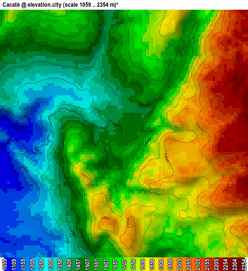
Below is the Elevation map of Cacaté, which displays elevation range with different colors. Scale of the first map is from 1059 to 2354 m (3474 to 7723 ft) with average elevation of 1632.4 meters (=5356 ft) [note 1]
These maps also provides idea of topography and contour of this city, they are displayed at different zoom levels. More info about maps, scale and edge coordinates you can find below images.
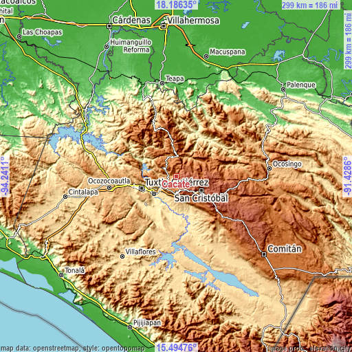
| \ | Map #1 | Topo.Map |
| Scale [m] | 1059..2354 m | × |
| Scale [ft] | 3474..7723 ft | × |
| Average | 1632.4 m = 5356 ft | × |
| Width | 9.35 km = 5.8 mi | 299.3 km = 186 mi |
| Height | 9.35 km = 5.8 mi | 299.3 km = 186 mi |
| ↑Max Latitude | 16.887395° | 18.18635° |
| Latitude at center | 16.84534° | 16.84534° |
| ↓Min Latitude | 16.803276° | 15.49476° |
| ← Min Longitude | -92.878795° | -94.2411° |
| Longitude center | -92.83485° | -92.83485° |
| →Max Longitude | -92.790905° | -91.4286° |
Nearby cities:
Cities around Cacaté sort by population:
• Ixtapa elevation 1116 m
8.8 km,  238°
238°
• Navenchauc 2254 m
13.6 km,  154°
154°
• Soyaló 1172 m
10.8 km,  298°
298°
• Larráinzar 2018 m
13.6 km,  71°
71°
• El Nopal 1549 m
7.4 km,  351°
351°
• Yaltem 2302 m
4.7 km,  91°
91°
• Catishtic 2247 m
12.6 km,  124°
124°
• Bautista Chico 2398 m
14 km,  111°
111°
• Aztlán 1143 m
12.7 km,  227°
227°
• Arvenza Uno 2314 m
14.2 km, 120°
• El Zapotillo 1012 m
12.5 km,  265°
265°
• Pugchén Mumuntic 1603 m
2.4 km,  30°
30°
Multilingual:
 En español:
Cacaté elevación 1476 m.
 En France:
Cacaté élévation 1476 m.


Sources and notes:
- [note 1] Map square and city borders are not equal. Map elevation data is calculated only from area inside that square.
- [src 1] Elevation data from geonames database provided with same terms of usage.
- [src 2] The elevation map of Cacaté is generated using elevation data from NASA's 3 arcsec (90m) resolution SRTM data.
- [src 3] Base (background) map © OpenStreetMap contributors tiles are generated by Geofabrik and OpenTopoMap.
Copyright & License:
This Cacaté Elevation Map is licensed under CC BY-SA. You may reuse any part from this page, if you give a proper credit by linking to this URL:
 More info on terms of use page.