Bochil elevation
Bochil (Chiapas), Mexico elevation is 1162 meters and Bochil elevation in feet is 3812 ft above sea level [src 1]. Bochil is a seat of a second-order administrative division (feature code) with elevation that is 152 meters (499 ft) smaller than average city elevation in Mexico.
Below is the Elevation map of Bochil, which displays elevation range with different colors. Scale of the first map is from 1110 to 2020 m (3642 to 6627 ft) with average elevation of 1403.1 meters (=4603 ft) [note 1]
These maps also provides idea of topography and contour of this city, they are displayed at different zoom levels. More info about maps, scale and edge coordinates you can find below images.
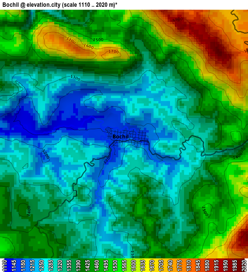
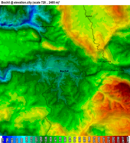
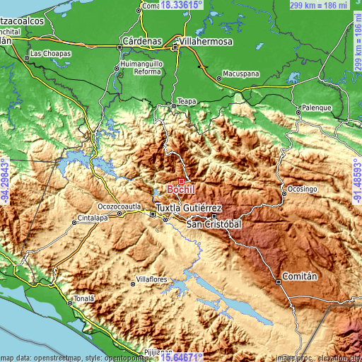
| \ | Map #1 | Map #2 | Topo.Map |
| Scale [m] | 1110..2020 m | 728..2485 m | × |
| Scale [ft] | 3642..6627 ft | 2388..8153 ft | × |
| Average | 1403.1 m = 4603 ft | 1545.8 m = 5072 ft | × |
| Width | 9.35 km = 5.8 mi | 18.69 km = 11.6 mi | 299 km = 185.8 mi |
| Height | 9.35 km = 5.8 mi | 18.69 km = 11.6 mi | 299.1 km = 185.9 mi |
| ↑Max Latitude | 17.038271° | 17.080283° | 18.33615° |
| Latitude at center | 16.99625° | 16.99625° | 16.99625° |
| ↓Min Latitude | 16.954219° | 16.912179° | 15.64671° |
| ← Min Longitude | -92.936125° | -92.980071° | -94.29843° |
| Longitude center | -92.89218° | -92.89218° | -92.89218° |
| →Max Longitude | -92.848235° | -92.804289° | -91.48593° |
Nearby cities:
Cities around Bochil sort by population:
• Jitotol elevation 1662 m
8.6 km,  22°
22°
• Soyaló 1172 m
12.2 km,  196°
196°
• Francisco Sarabia 865 m
14 km,  246°
246°
• Carmen Zacatal 1628 m
13.4 km,  45°
45°
• Maravillas 1699 m
11.2 km,  0°
0°
• El Nopal 1549 m
10.7 km,  151°
151°
• San Cayetano 1511 m
14.6 km,  105°
105°
• Ajilhó 1312 m
5.1 km, 254°
• Cálido 1318 m
15.9 km,  44°
44°
• El Ámbar 1605 m
6.9 km,  62°
62°
• El Copal 1392 m
4.8 km,  228°
228°
• Luis Espinoza 1442 m
14.9 km,  285°
285°
Multilingual:
 En español:
Bochil elevación 1162 m.
 En France:
Bochil élévation 1162 m.


Sources and notes:
- [note 1] Map square and city borders are not equal. Map elevation data is calculated only from area inside that square.
- [src 1] Elevation data from geonames database provided with same terms of usage.
- [src 2] The elevation map of Bochil is generated using elevation data from NASA's 3 arcsec (90m) resolution SRTM data.
- [src 3] Base (background) map © OpenStreetMap contributors tiles are generated by Geofabrik and OpenTopoMap.
Copyright & License:
This Bochil Elevation Map is licensed under CC BY-SA. You may reuse any part from this page, if you give a proper credit by linking to this URL:
 More info on terms of use page.