Jitotol elevation
Jitotol (Chiapas), Mexico elevation is 1662 meters and Jitotol elevation in feet is 5453 ft above sea level [src 1]. Jitotol is a seat of a second-order administrative division (feature code) with elevation that is 348 meters (1142 ft) bigger than average city elevation in Mexico.
Below is the Elevation map of Jitotol, which displays elevation range with different colors. Scale of the first map is from 1343 to 2281 m (4406 to 7484 ft) with average elevation of 1745.8 meters (=5728 ft) [note 1]
These maps also provides idea of topography and contour of this city, they are displayed at different zoom levels. More info about maps, scale and edge coordinates you can find below images.
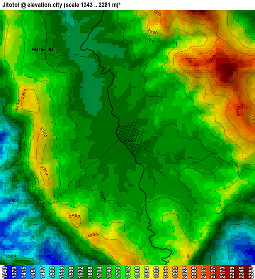
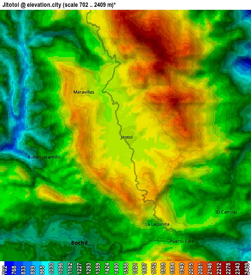
| \ | Map #1 | Map #2 | Topo.Map |
| Scale [m] | 1343..2281 m | 702..2409 m | × |
| Scale [ft] | 4406..7484 ft | 2303..7904 ft | × |
| Average | 1745.8 m = 5728 ft | 1517.6 m = 4979 ft | × |
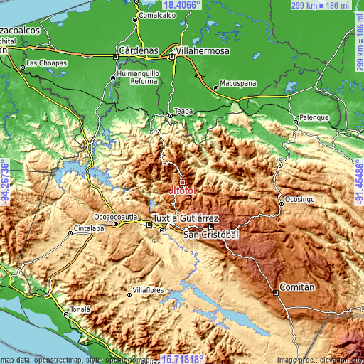
| Width | 9.34 km = 5.8 mi | 18.68 km = 11.6 mi | 298.9 km = 185.7 mi |
| Height | 9.34 km = 5.8 mi | 18.68 km = 11.6 mi | 298.9 km = 185.7 mi |
| ↑Max Latitude | 17.109235° | 17.151231° | 18.4066° |
| Latitude at center | 17.06723° | 17.06723° | 17.06723° |
| ↓Min Latitude | 17.025215° | 16.983191° | 15.71818° |
| ← Min Longitude | -92.905055° | -92.949001° | -94.26736° |
| Longitude center | -92.86111° | -92.86111° | -92.86111° |
| →Max Longitude | -92.817165° | -92.773219° | -91.45486° |
Nearby cities:
Cities around Jitotol sort by population:
• Bochil elevation 1162 m
8.6 km,  202°
202°
• Pueblo Nuevo 1727 m
11.1 km,  338°
338°
• San Andrés Duraznal 1579 m
9.3 km,  39°
39°
• Carmen Zacatal 1628 m
6.4 km,  76°
76°
• Maravillas 1699 m
4.6 km,  316°
316°
• Los Plátanos 1183 m
14.3 km,  118°
118°
• La Pimienta 823 m
13.3 km,  51°
51°
• Ajilhó 1312 m
12.4 km,  221°
221°
• Cálido 1318 m
8.6 km,  65°
65°
• Arroyo Grande 1758 m
13.8 km,  355°
355°
• El Ámbar 1605 m
5.5 km,  148°
148°
• El Copal 1392 m
13.1 km,  211°
211°
Multilingual:
 En español:
Jitotol de Zaragoza elevación 1662 m.
 En France:
Jitotol élévation 1662 m.
 Auf Deutsch:
Jitotol höhe über dem Meeresspiegel ist 1662 m.

Sources and notes:
- [note 1] Map square and city borders are not equal. Map elevation data is calculated only from area inside that square.
- [src 1] Elevation data from geonames database provided with same terms of usage.
- [src 2] The elevation map of Jitotol is generated using elevation data from NASA's 3 arcsec (90m) resolution SRTM data.
- [src 3] Base (background) map © OpenStreetMap contributors tiles are generated by Geofabrik and OpenTopoMap.
Copyright & License:
This Jitotol Elevation Map is licensed under CC BY-SA. You may reuse any part from this page, if you give a proper credit by linking to this URL:
 More info on terms of use page.