Tatatila elevation
Tatatila (Veracruz), Mexico elevation is 2061 meters and Tatatila elevation in feet is 6762 ft above sea level [src 1]. Tatatila is a seat of a second-order administrative division (feature code) with elevation that is 747 meters (2451 ft) bigger than average city elevation in Mexico.
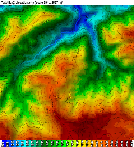
Below is the Elevation map of Tatatila, which displays elevation range with different colors. Scale of the first map is from 884 to 2557 m (2900 to 8389 ft) with average elevation of 1783.5 meters (=5851 ft) [note 1]
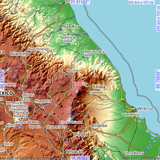
These maps also provides idea of topography and contour of this city, they are displayed at different zoom levels. More info about maps, scale and edge coordinates you can find below images.
| \ | Map #1 | Topo.Map |
| Scale [m] | 884..2557 m | × |
| Scale [ft] | 2900..8389 ft | × |
| Average | 1783.5 m = 5851 ft | × |
| Width | 9.2 km = 5.7 mi | 294.4 km = 182.9 mi |
| Height | 9.2 km = 5.7 mi | 294.4 km = 182.9 mi |
| ↑Max Latitude | 19.73457° | 21.01162° |
| Latitude at center | 19.6932° | 19.6932° |
| ↓Min Latitude | 19.65182° | 18.36383° |
| ← Min Longitude | -97.155545° | -98.51785° |
| Longitude center | -97.1116° | -97.1116° |
| →Max Longitude | -97.067655° | -95.70535° |
Nearby cities:
Cities around Tatatila sort by population:
• Las Vigas de Ramírez elevation 2438 m
6.4 km,  167°
167°
• Colonia Libertad 2442 m
10.7 km,  260°
260°
• Villa Aldama 2409 m
12.7 km,  247°
247°
• Juan Marcos (San José Buenavista) 2196 m
9.8 km,  294°
294°
• Ignacio Zaragoza 2165 m
12.1 km,  280°
280°
• San Miguel Tlalpoalán 2072 m
13.1 km, 293°
• Cruz Blanca 2394 m
8.5 km,  223°
223°
• Gutiérrez Zamora 2146 m
11.4 km, 287°
• Tlacolulan 1755 m
11.8 km,  104°
104°
• La Joya 2169 m
12.7 km,  135°
135°
• Barrio de San Miguel 2417 m
5.7 km,  193°
193°
• Las Minas 1353 m
3.6 km,  265°
265°
Multilingual:
 En español:
Tatatila elevación 2061 m.
 En France:
Tatatila élévation 2061 m.
 Auf Deutsch:
Tatatila höhe über dem Meeresspiegel ist 2061 m.

Sources and notes:
- [note 1] Map square and city borders are not equal. Map elevation data is calculated only from area inside that square.
- [src 1] Elevation data from geonames database provided with same terms of usage.
- [src 2] The elevation map of Tatatila is generated using elevation data from NASA's 3 arcsec (90m) resolution SRTM data.
- [src 3] Base (background) map © OpenStreetMap contributors tiles are generated by Geofabrik and OpenTopoMap.
Copyright & License:
This Tatatila Elevation Map is licensed under CC BY-SA. You may reuse any part from this page, if you give a proper credit by linking to this URL:
 More info on terms of use page.