Cruz Blanca elevation
Cruz Blanca (Veracruz, Villa Aldama), Mexico elevation is 2394 meters and Cruz Blanca elevation in feet is 7854 ft above sea level [src 1]. Cruz Blanca is a populated place (feature code) with elevation that is 1080 meters (3543 ft) bigger than average city elevation in Mexico.
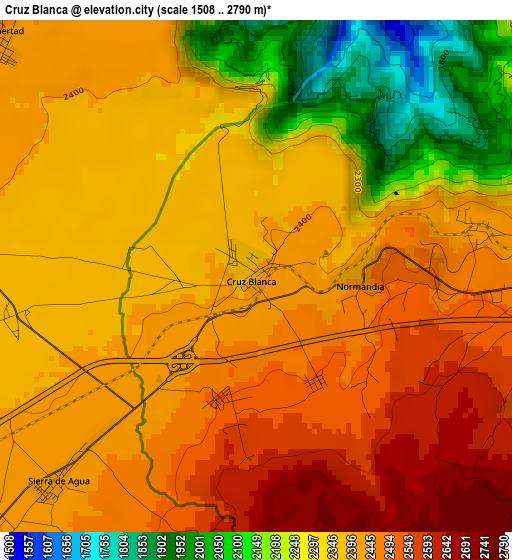
Below is the Elevation map of Cruz Blanca, which displays elevation range with different colors. Scale of the first map is from 1508 to 2790 m (4948 to 9154 ft) with average elevation of 2377.3 meters (=7800 ft) [note 1]
These maps also provides idea of topography and contour of this city, they are displayed at different zoom levels. More info about maps, scale and edge coordinates you can find below images.
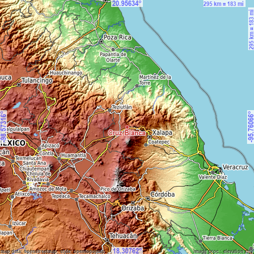
| \ | Map #1 | Topo.Map |
| Scale [m] | 1508..2790 m | × |
| Scale [ft] | 4948..9154 ft | × |
| Average | 2377.3 m = 7800 ft | × |
| Width | 9.2 km = 5.7 mi | 294.5 km = 183 mi |
| Height | 9.2 km = 5.7 mi | 294.5 km = 183 mi |
| ↑Max Latitude | 19.678824° | 20.95634° |
| Latitude at center | 19.63744° | 19.63744° |
| ↓Min Latitude | 19.596045° | 18.30762° |
| ← Min Longitude | -97.210855° | -98.57316° |
| Longitude center | -97.16691° | -97.16691° |
| →Max Longitude | -97.122965° | -95.76066° |
Nearby cities:
Cities around Cruz Blanca sort by population:
• Las Vigas de Ramírez elevation 2438 m
7.2 km,  90°
90°
• Colonia Libertad 2442 m
6.5 km,  312°
312°
• Villa Aldama 2409 m
6 km,  281°
281°
• Los Molinos 2428 m
6.9 km,  227°
227°
• Juan Marcos (San José Buenavista) 2196 m
10.7 km,  343°
343°
• Centro de Readaptación Social 2378 m
5.8 km,  256°
256°
• Ignacio Zaragoza 2165 m
10.3 km,  323°
323°
• Sierra de Agua 2419 m
5 km,  224°
224°
• Los Pescados 2988 m
8.7 km,  167°
167°
• Barrio de San Miguel 2417 m
4.6 km,  81°
81°
• Tatatila 2061 m
8.5 km,  43°
43°
• Las Minas 1353 m
6.3 km,  20°
20°
Multilingual:
 En español:
Cruz Blanca elevación 2394 m.
 En France:
Cruz Blanca élévation 2394 m.
 Auf Deutsch:
Cruz Blanca höhe über dem Meeresspiegel ist 2394 m.

Sources and notes:
- [note 1] Map square and city borders are not equal. Map elevation data is calculated only from area inside that square.
- [src 1] Elevation data from geonames database provided with same terms of usage.
- [src 2] The elevation map of Cruz Blanca is generated using elevation data from NASA's 3 arcsec (90m) resolution SRTM data.
- [src 3] Base (background) map © OpenStreetMap contributors tiles are generated by Geofabrik and OpenTopoMap.
Copyright & License:
This Cruz Blanca Elevation Map is licensed under CC BY-SA. You may reuse any part from this page, if you give a proper credit by linking to this URL:
 More info on terms of use page.