Villa Aldama elevation
Villa Aldama (Veracruz), Mexico elevation is 2409 meters and Villa Aldama elevation in feet is 7904 ft above sea level [src 1]. Villa Aldama is a populated place (feature code) with elevation that is 1095 meters (3593 ft) bigger than average city elevation in Mexico.
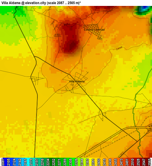
Below is the Elevation map of Villa Aldama, which displays elevation range with different colors. Scale of the first map is from 2087 to 2565 m (6847 to 8415 ft) with average elevation of 2397.6 meters (=7866 ft) [note 1]
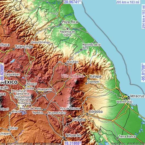
These maps also provides idea of topography and contour of this city, they are displayed at different zoom levels. More info about maps, scale and edge coordinates you can find below images.
| \ | Map #1 | Topo.Map |
| Scale [m] | 2087..2565 m | × |
| Scale [ft] | 6847..8415 ft | × |
| Average | 2397.6 m = 7866 ft | × |
| Width | 9.2 km = 5.7 mi | 294.5 km = 183 mi |
| Height | 9.2 km = 5.7 mi | 294.5 km = 183 mi |
| ↑Max Latitude | 19.689991° | 20.96741° |
| Latitude at center | 19.64861° | 19.64861° |
| ↓Min Latitude | 19.607218° | 18.31888° |
| ← Min Longitude | -97.267275° | -98.62958° |
| Longitude center | -97.22333° | -97.22333° |
| →Max Longitude | -97.179385° | -95.81708° |
Nearby cities:
Cities around Villa Aldama sort by population:
• Colonia Libertad elevation 2442 m
3.4 km,  19°
19°
• Los Molinos 2428 m
6 km,  171°
171°
• Juan Marcos (San José Buenavista) 2196 m
9.4 km, 17°
• Ahueyahualco 2163 m
8.8 km,  334°
334°
• Orilla del Monte 2402 m
7.4 km,  280°
280°
• Centro de Readaptación Social 2378 m
2.6 km, 173°
• Mixquiapan 2302 m
8.2 km,  315°
315°
• Ignacio Zaragoza 2165 m
7.1 km,  358°
358°
• Sierra de Agua 2419 m
5.4 km,  153°
153°
• Cruz Blanca 2394 m
6 km,  101°
101°
• Gutiérrez Zamora 2146 m
8.4 km,  5°
5°
• Adolfo Moreno 2146 m
8.6 km,  349°
349°
Multilingual:
 En español:
Villa Aldama elevación 2409 m.
 En France:
Villa Aldama élévation 2409 m.
 Auf Deutsch:
Villa Aldama höhe über dem Meeresspiegel ist 2409 m.

Sources and notes:
- [note 1] Map square and city borders are not equal. Map elevation data is calculated only from area inside that square.
- [src 1] Elevation data from geonames database provided with same terms of usage.
- [src 2] The elevation map of Villa Aldama is generated using elevation data from NASA's 3 arcsec (90m) resolution SRTM data.
- [src 3] Base (background) map © OpenStreetMap contributors tiles are generated by Geofabrik and OpenTopoMap.
Copyright & License:
This Villa Aldama Elevation Map is licensed under CC BY-SA. You may reuse any part from this page, if you give a proper credit by linking to this URL:
 More info on terms of use page.