La Joya elevation
La Joya (Veracruz, Acajete), Mexico elevation is 2169 meters and La Joya elevation in feet is 7116 ft above sea level [src 1]. La Joya is a populated place (feature code) with elevation that is 855 meters (2805 ft) bigger than average city elevation in Mexico.
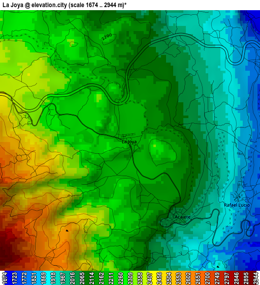
Below is the Elevation map of La Joya, which displays elevation range with different colors. Scale of the first map is from 1674 to 2944 m (5492 to 9659 ft) with average elevation of 2170.7 meters (=7122 ft) [note 1]
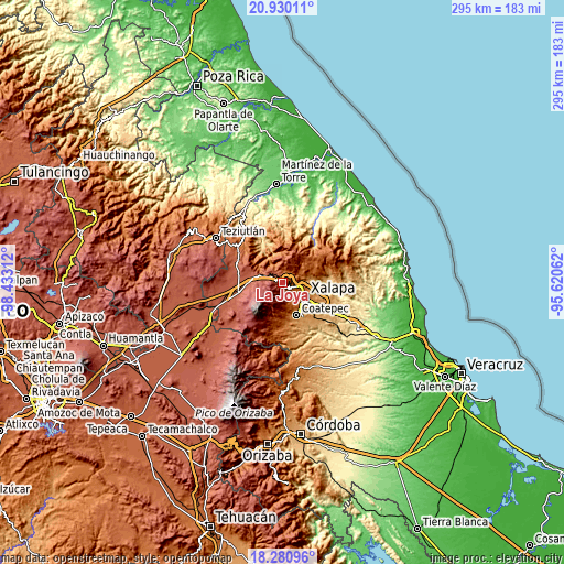
These maps also provides idea of topography and contour of this city, they are displayed at different zoom levels. More info about maps, scale and edge coordinates you can find below images.
| \ | Map #1 | Topo.Map |
| Scale [m] | 1674..2944 m | × |
| Scale [ft] | 5492..9659 ft | × |
| Average | 2170.7 m = 7122 ft | × |
| Width | 9.21 km = 5.7 mi | 294.6 km = 183.1 mi |
| Height | 9.21 km = 5.7 mi | 294.6 km = 183.1 mi |
| ↑Max Latitude | 19.652381° | 20.93011° |
| Latitude at center | 19.61099° | 19.61099° |
| ↓Min Latitude | 19.569588° | 18.28096° |
| ← Min Longitude | -97.070815° | -98.43312° |
| Longitude center | -97.02687° | -97.02687° |
| →Max Longitude | -96.982925° | -95.62062° |
Nearby cities:
Cities around La Joya sort by population:
• Banderilla elevation 1500 m
9.7 km,  104°
104°
• Las Vigas de Ramírez 2438 m
8 km,  291°
291°
• Coacoatzintla 1451 m
10.1 km,  63°
63°
• Guadalupe Victoria 1457 m
9.3 km,  132°
132°
• Rafael Lucio 1827 m
4.3 km,  117°
117°
• Jilotepec 1382 m
7.9 km,  89°
89°
• Otilpan 1574 m
8 km,  138°
138°
• Acajete 2028 m
3.3 km,  146°
146°
• Piletas 1689 m
5.7 km, 116°
• Tlacolulan 1755 m
6.7 km,  22°
22°
• Barrio de San Miguel 2417 m
10.8 km, 289°
• Tlalnelhuayocan 1664 m
7.3 km, 132°
Multilingual:
 En español:
La Joya elevación 2169 m.
 En France:
La Joya élévation 2169 m.
 Auf Deutsch:
La Joya höhe über dem Meeresspiegel ist 2169 m.

Sources and notes:
- [note 1] Map square and city borders are not equal. Map elevation data is calculated only from area inside that square.
- [src 1] Elevation data from geonames database provided with same terms of usage.
- [src 2] The elevation map of La Joya is generated using elevation data from NASA's 3 arcsec (90m) resolution SRTM data.
- [src 3] Base (background) map © OpenStreetMap contributors tiles are generated by Geofabrik and OpenTopoMap.
Copyright & License:
This La Joya Elevation Map is licensed under CC BY-SA. You may reuse any part from this page, if you give a proper credit by linking to this URL:
 More info on terms of use page.