Coacoatzintla elevation
Coacoatzintla (Veracruz), Mexico elevation is 1451 meters and Coacoatzintla elevation in feet is 4760 ft above sea level [src 1]. Coacoatzintla is a seat of a second-order administrative division (feature code) with elevation that is 137 meters (449 ft) bigger than average city elevation in Mexico.
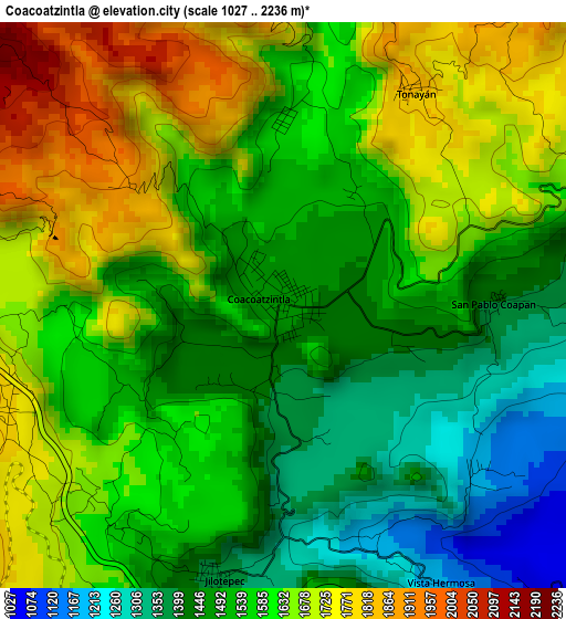
Below is the Elevation map of Coacoatzintla, which displays elevation range with different colors. Scale of the first map is from 1027 to 2236 m (3369 to 7336 ft) with average elevation of 1570.2 meters (=5152 ft) [note 1]
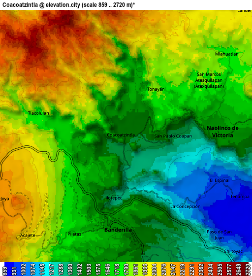
These maps also provides idea of topography and contour of this city, they are displayed at different zoom levels. More info about maps, scale and edge coordinates you can find below images.
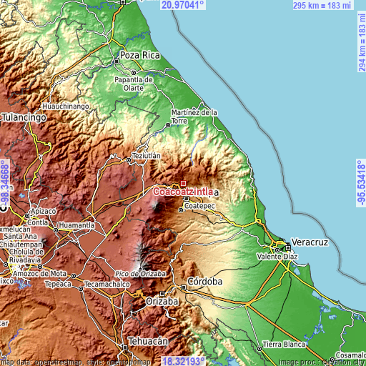
| \ | Map #1 | Map #2 | Topo.Map |
| Scale [m] | 1027..2236 m | 859..2720 m | × |
| Scale [ft] | 3369..7336 ft | 2818..8924 ft | × |
| Average | 1570.2 m = 5152 ft | 1715.7 m = 5629 ft | × |
| Width | 9.2 km = 5.7 mi | 18.41 km = 11.4 mi | 294.5 km = 183 mi |
| Height | 9.2 km = 5.7 mi | 18.41 km = 11.4 mi | 294.5 km = 183 mi |
| ↑Max Latitude | 19.69301° | 19.73438° | 20.97041° |
| Latitude at center | 19.65163° | 19.65163° | 19.65163° |
| ↓Min Latitude | 19.610239° | 19.568837° | 18.32193° |
| ← Min Longitude | -96.984375° | -97.028321° | -98.34668° |
| Longitude center | -96.94043° | -96.94043° | -96.94043° |
| →Max Longitude | -96.896485° | -96.852539° | -95.53418° |
Nearby cities:
Cities around Coacoatzintla sort by population:
• Banderilla elevation 1500 m
7 km,  177°
177°
• Naolinco de Victoria 1555 m
7 km,  87°
87°
• Rafael Lucio 1827 m
8.3 km,  218°
218°
• Jilotepec 1382 m
4.6 km,  194°
194°
• La Concepción 1092 m
6.6 km,  140°
140°
• Miahuatlán 1792 m
9.6 km,  49°
49°
• El Espinal 986 m
7.7 km,  113°
113°
• San Marcos Atesquilapan 1779 m
7.2 km, 53°
• Piletas 1689 m
8.1 km,  209°
209°
• Tlacolulan 1755 m
6.7 km,  284°
284°
• Tonayán 1830 m
4 km,  30°
30°
• El Pueblito (Garbanzal) 1412 m
6.6 km,  165°
165°
Multilingual:
 En español:
Coacotzintla elevación 1451 m.
 En France:
Coacoatzintla élévation 1451 m.
 Auf Deutsch:
Coacoatzintla höhe über dem Meeresspiegel ist 1451 m.

Sources and notes:
- [note 1] Map square and city borders are not equal. Map elevation data is calculated only from area inside that square.
- [src 1] Elevation data from geonames database provided with same terms of usage.
- [src 2] The elevation map of Coacoatzintla is generated using elevation data from NASA's 3 arcsec (90m) resolution SRTM data.
- [src 3] Base (background) map © OpenStreetMap contributors tiles are generated by Geofabrik and OpenTopoMap.
Copyright & License:
This Coacoatzintla Elevation Map is licensed under CC BY-SA. You may reuse any part from this page, if you give a proper credit by linking to this URL:
 More info on terms of use page.