Tempoal de Sánchez elevation
Tempoal de Sánchez (Veracruz, Tempoal), Mexico elevation is 64 meters and Tempoal de Sánchez elevation in feet is 210 ft above sea level [src 1]. Tempoal de Sánchez is a seat of a second-order administrative division (feature code) with elevation that is 1250 meters (4101 ft) smaller than average city elevation in Mexico.
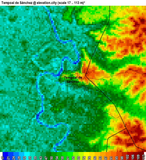
Below is the Elevation map of Tempoal de Sánchez, which displays elevation range with different colors. Scale of the first map is from 17 to 113 m (56 to 371 ft) with average elevation of 53.8 meters (=177 ft) [note 1]
These maps also provides idea of topography and contour of this city, they are displayed at different zoom levels. More info about maps, scale and edge coordinates you can find below images.
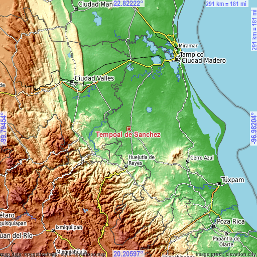
| \ | Map #1 | Map #2 | Topo.Map |
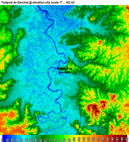
| Scale [m] | 17..113 m | 17..162 m | × |
| Scale [ft] | 56..371 ft | 56..531 ft | × |
| Average | 53.8 m = 177 ft | 65.2 m = 214 ft | × |
| Width | 9.09 km = 5.6 mi | 18.18 km = 11.3 mi | 290.9 km = 180.8 mi |
| Height | 9.09 km = 5.6 mi | 18.18 km = 11.3 mi | 290.9 km = 180.8 mi |
| ↑Max Latitude | 21.560856° | 21.601721° | 22.82222° |
| Latitude at center | 21.51998° | 21.51998° | 21.51998° |
| ↓Min Latitude | 21.479092° | 21.438193° | 20.20597° |
| ← Min Longitude | -98.432235° | -98.476181° | -99.79454° |
| Longitude center | -98.38829° | -98.38829° | -98.38829° |
| →Max Longitude | -98.344345° | -98.300399° | -96.98204° |
Nearby cities:
Cities around Tempoal de Sánchez sort by population:
• Tantoyuca elevation 167 m
25.3 km,  138°
138°
• Platón Sánchez 70 m
27.6 km,  177°
177°
• Tanquián de Escobedo 59 m
29.9 km,  288°
288°
• El Higo 34 m
28.2 km,  346°
346°
• San Vicente Tancuayalab 49 m
30.2 km,  317°
317°
• San Martín Chalchicuautla 188 m
32.4 km,  239°
239°
• Chalma 150 m
34.6 km, 181°
• Corozal 131 m
17.4 km,  279°
279°
• Chiconamel 139 m
33 km,  193°
193°
• El Pueblito 40 m
31.9 km, 347°
• San Pedro Coyutla 182 m
33.2 km, 187°
• El Lindero 176 m
28.9 km, 142°
Multilingual:
 En español:
Tempoal de Sánchez elevación 64 m.
 En France:
Tempoal de Sánchez élévation 64 m.
 Auf Deutsch:
Tempoal de Sánchez höhe über dem Meeresspiegel ist 64 m.

Sources and notes:
- [note 1] Map square and city borders are not equal. Map elevation data is calculated only from area inside that square.
- [src 1] Elevation data from geonames database provided with same terms of usage.
- [src 2] The elevation map of Tempoal de Sánchez is generated using elevation data from NASA's 3 arcsec (90m) resolution SRTM data.
- [src 3] Base (background) map © OpenStreetMap contributors tiles are generated by Geofabrik and OpenTopoMap.
Copyright & License:
This Tempoal de Sánchez Elevation Map is licensed under CC BY-SA. You may reuse any part from this page, if you give a proper credit by linking to this URL:
 More info on terms of use page.