Tantoyuca elevation
Tantoyuca (Veracruz), Mexico elevation is 167 meters and Tantoyuca elevation in feet is 548 ft above sea level [src 1]. Tantoyuca is a seat of a second-order administrative division (feature code) with elevation that is 1147 meters (3763 ft) smaller than average city elevation in Mexico.
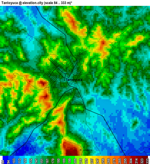
Below is the Elevation map of Tantoyuca, which displays elevation range with different colors. Scale of the first map is from 84 to 333 m (276 to 1093 ft) with average elevation of 166 meters (=545 ft) [note 1]
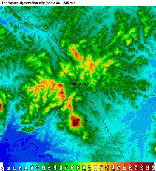
These maps also provides idea of topography and contour of this city, they are displayed at different zoom levels. More info about maps, scale and edge coordinates you can find below images.
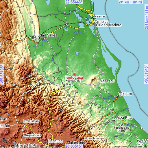
| \ | Map #1 | Map #2 | Topo.Map |
| Scale [m] | 84..333 m | 44..345 m | × |
| Scale [ft] | 276..1093 ft | 144..1132 ft | × |
| Average | 166 m = 545 ft | 129.8 m = 426 ft | × |
| Width | 9.1 km = 5.7 mi | 18.2 km = 11.3 mi | 291.2 km = 180.9 mi |
| Height | 9.1 km = 5.7 mi | 18.2 km = 11.3 mi | 291.3 km = 181 mi |
| ↑Max Latitude | 21.391564° | 21.432476° | 22.65443° |
| Latitude at center | 21.35064° | 21.35064° | 21.35064° |
| ↓Min Latitude | 21.309705° | 21.268758° | 20.03515° |
| ← Min Longitude | -98.269645° | -98.313591° | -99.63195° |
| Longitude center | -98.2257° | -98.2257° | -98.2257° |
| →Max Longitude | -98.181755° | -98.137809° | -96.81945° |
Nearby cities:
Cities around Tantoyuca sort by population:
• Tempoal de Sánchez elevation 64 m
25.3 km,  318°
318°
• Platón Sánchez 70 m
17.7 km,  240°
240°
• Ixcatepec 208 m
26 km,  119°
119°
• Chalma 150 m
23.8 km,  228°
228°
• Parque de Poblamiento Solidaridad 124 m
27.6 km,  216°
216°
• Chiconamel 139 m
27.7 km, 241°
• Chapopote Chico 106 m
23.9 km,  185°
185°
• Chalahuiyapa 115 m
26.5 km,  212°
212°
• Tancazahuela 182 m
28.6 km, 229°
• San Sebastián 112 m
17.7 km,  146°
146°
• San Pedro Coyutla 182 m
25.4 km, 236°
• El Lindero 176 m
4.3 km,  172°
172°
Multilingual:
 En español:
Tantoyuca elevación 167 m.
 En France:
Tantoyuca élévation 167 m.
 Auf Deutsch:
Tantoyuca höhe über dem Meeresspiegel ist 167 m.

Sources and notes:
- [note 1] Map square and city borders are not equal. Map elevation data is calculated only from area inside that square.
- [src 1] Elevation data from geonames database provided with same terms of usage.
- [src 2] The elevation map of Tantoyuca is generated using elevation data from NASA's 3 arcsec (90m) resolution SRTM data.
- [src 3] Base (background) map © OpenStreetMap contributors tiles are generated by Geofabrik and OpenTopoMap.
Copyright & License:
This Tantoyuca Elevation Map is licensed under CC BY-SA. You may reuse any part from this page, if you give a proper credit by linking to this URL:
 More info on terms of use page.