Corozal elevation
Corozal (Veracruz, Tempoal), Mexico elevation is 131 meters and Corozal elevation in feet is 430 ft above sea level [src 1]. Corozal is a populated place (feature code) with elevation that is 1183 meters (3881 ft) smaller than average city elevation in Mexico.
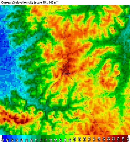
Below is the Elevation map of Corozal, which displays elevation range with different colors. Scale of the first map is from 45 to 143 m (148 to 469 ft) with average elevation of 94 meters (=308 ft) [note 1]
These maps also provides idea of topography and contour of this city, they are displayed at different zoom levels. More info about maps, scale and edge coordinates you can find below images.
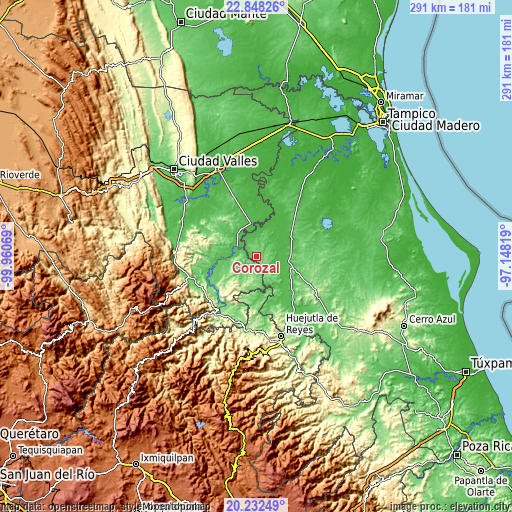
| \ | Map #1 | Topo.Map |
| Scale [m] | 45..143 m | × |
| Scale [ft] | 148..469 ft | × |
| Average | 94 m = 308 ft | × |
| Width | 9.09 km = 5.6 mi | 290.8 km = 180.7 mi |
| Height | 9.09 km = 5.6 mi | 290.9 km = 180.8 mi |
| ↑Max Latitude | 21.587139° | 22.84826° |
| Latitude at center | 21.54627° | 21.54627° |
| ↓Min Latitude | 21.50539° | 20.23249° |
| ← Min Longitude | -98.598385° | -99.96069° |
| Longitude center | -98.55444° | -98.55444° |
| →Max Longitude | -98.510495° | -97.14819° |
Nearby cities:
Cities around Corozal sort by population:
• Tempoal de Sánchez elevation 64 m
17.4 km,  99°
99°
• Tanquián de Escobedo 59 m
13 km,  300°
300°
• El Higo 34 m
26.7 km,  23°
23°
• San Vicente Tancuayalab 49 m
19.5 km,  349°
349°
• Tampamolón Corona 99 m
27.4 km,  272°
272°
• San Martín Chalchicuautla 188 m
22.3 km,  208°
208°
• Tampacán 140 m
24.1 km,  228°
228°
• San Francisco Cuayalab 184 m
26.7 km,  320°
320°
• Chiconamel 252 m
26.1 km,  220°
220°
• El Pueblito 40 m
29.9 km, 19°
• Ocuiltzapoyo 140 m
30.6 km, 216°
• San Nicolás 154 m
27.3 km, 302°
Multilingual:
 En español:
Corozal elevación 131 m.
 En France:
Corozal élévation 131 m.


Sources and notes:
- [note 1] Map square and city borders are not equal. Map elevation data is calculated only from area inside that square.
- [src 1] Elevation data from geonames database provided with same terms of usage.
- [src 2] The elevation map of Corozal is generated using elevation data from NASA's 3 arcsec (90m) resolution SRTM data.
- [src 3] Base (background) map © OpenStreetMap contributors tiles are generated by Geofabrik and OpenTopoMap.
Copyright & License:
This Corozal Elevation Map is licensed under CC BY-SA. You may reuse any part from this page, if you give a proper credit by linking to this URL:
 More info on terms of use page.